Here's something you might be interested in.
Ask a Hipster — Advice you didn't know you needed
Big Screen — Movie commentary
Blurt — Music's inside track
Booze News — San Diego spirits
Classical Music — Immortal beauty
Classifieds — Free and easy
Cover Stories — Front-page features
Drinks All Around — Bartenders' drink recipes
Excerpts — Literary and spiritual excerpts
Feast! — Food & drink reviews
Feature Stories — Local news & stories
Fishing Report — What’s getting hooked from ship and shore
From the Archives — Spotlight on the past
Golden Dreams — Talk of the town
The Gonzo Report — Making the musical scene, or at least reporting from it
Letters — Our inbox
Movies@Home — Local movie buffs share favorites
Movie Reviews — Our critics' picks and pans
Musician Interviews — Up close with local artists
Neighborhood News from Stringers — Hyperlocal news
News Ticker — News & politics
Obermeyer — San Diego politics illustrated
Outdoors — Weekly changes in flora and fauna
Overheard in San Diego — Eavesdropping illustrated
Poetry — The old and the new
Reader Travel — Travel section built by travelers
Reading — The hunt for intellectuals
Roam-O-Rama — SoCal's best hiking/biking trails
San Diego Beer — Inside San Diego suds
SD on the QT — Almost factual news
Sheep and Goats — Places of worship
Special Issues — The best of
Street Style — San Diego streets have style
Surf Diego — Real stories from those braving the waves
Theater — On stage in San Diego this week
Tin Fork — Silver spoon alternative
Under the Radar — Matt Potter's undercover work
Unforgettable — Long-ago San Diego
Unreal Estate — San Diego's priciest pads
Your Week — Daily event picks
Your rewards are amazing views and vigorous exercise
Clevenger Canyon is rich in wildflowers and blooming chaparral shrubs in season
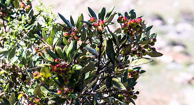
Mission manzanita “apples” along the trail
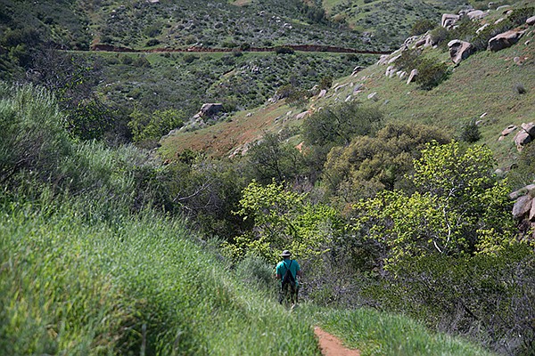
On the trail down to Santa Ysabel Creek
Clevenger Canyon is part of the Coast to Crest Trail of the San Dieguito River Parkway, a 70-mile trail that will eventually connect Volcan Mountain with the ocean at Del Mar. The Clevenger Canyon North trail has suffered from frequent fires and vandalism. Despite these degradations, it retains a number of attractions that make it worth a visit. Ignore the graffiti and take the short hike down to and along Santa Ysabel Creek. It is rich in wildflowers and blooming chaparral shrubs in season. The stream, whose banks are lined with oaks, willows, and sycamores, provides shade on hot days. The trail from the stream up the side of the canyon is a challenge some hikers will avoid, but if you do it you will be rewarded with amazing views as well as some vigorous exercise.
Santa Ysabel Creek in Clevenger Canyon
The trail descends quickly from the parking area. After passing through a short rock-framed tunnel and going down some stone steps, the descent becomes more gradual, reaching Santa Ysabel Creek in about 0.25 mile. Be sure to look for vines (wild cucumber, honeysuckle, and virgin’s bower) draped over yellow-flowered bush penstemon, mission manzanita, California sagebrush, or scrub oaks while hiking the trail. Some of the wildflowers you might see include wild hyacinth, larkspur, golden yarrow, wild heliotrope, wishbone bush, and white pincushion.
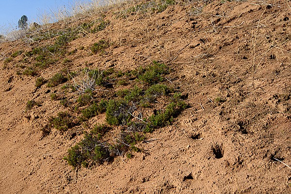
Cryptogamic soil viewed from the trail
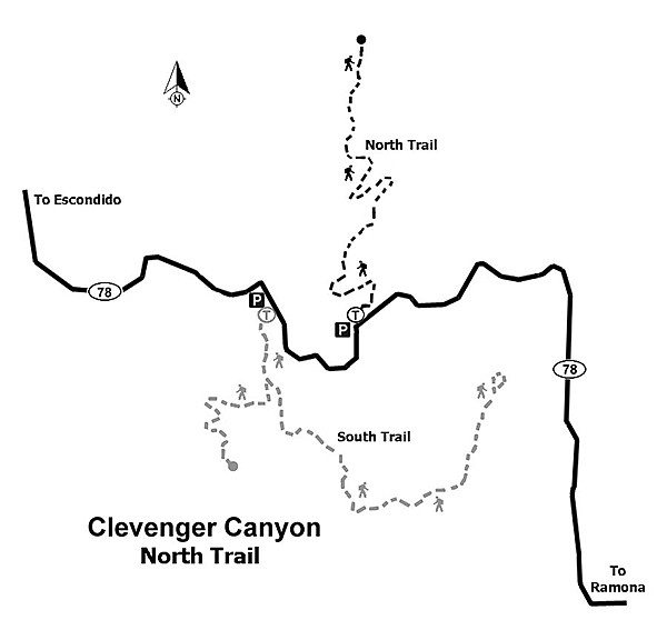
Map of Clevenger Canyon
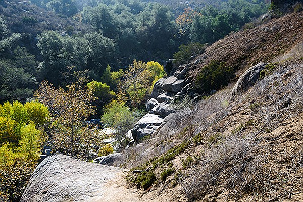
You likely won’t find a bubbling stream when you reach the canyon bottom. During drought years, you are likely to find only damp sand. Still, there is enough moisture remaining to support a forest of tall sycamores and both coast live oaks and Engelmann oaks along the stream banks. A dense growth of arroyo willow, wild grape, and false indigo grow under the trees. This oak woodland forest is a green ribbon running through Clevenger Canyon, up to the San Pasqual Valley Agriculture Preserve that begins just to the west.
The trail stays only briefly in the canyon before climbing up the bank and out of the forest. It follows the creek along a bench about 50 feet above the forest before ascending the south-facing slope of the canyon. It continues up this steep hillside through a series of switchbacks. This part of the hike can be strenuous and a good place to turn around if hiking on a hot day. It is about 1.25 miles to the top of a ridge, with about a 1200-foot gain in elevation. There is no shade and you are likely to be in the sun most of the way. Also, the trail becomes progressively indistinct and hard to follow near the top. Be sure to check your backtrail as you proceed to the top so that you can easily find your way back. A few years back the trail continued for some distance on top of the ridge, extending to three viewpoints, but wildfires led to the abandonment of this part of the trail. Still, you will be rewarded upon reaching the top of the ridge by views of the San Pasqual Valley and the surrounding hills. When you have rested, retrace your steps to your vehicle.
Distance from downtown San Diego: 39 miles. Allow 45 minutes driving time (San Pasqual Valley). From I-15 N, exit at Via Rancho Parkway and follow the signs for San Diego Zoo’s Safari Park (Bear Valley Pkwy to San Pasqual Rd.) to SR-78 E and continue east for about 12 miles to the Clevenger North trailhead parking area on the left (north) side of SR-78.
Hiking length: 3 miles out-and-back.
Difficulty: Moderately strenuous. Elevation gain/loss about 1500 feet. No facilities or water. Santa Ysabel Creek flows periodically but is not a source of drinking water unless treated. The parking area is open from dawn to dusk year-round. The best time to visit is November through May.
Here's something you might be interested in.
Your rewards are amazing views and vigorous exercise
Clevenger Canyon is rich in wildflowers and blooming chaparral shrubs in season
Your rewards are amazing views and vigorous exercise
Clevenger Canyon is rich in wildflowers and blooming chaparral shrubs in season
Mission manzanita “apples” along the trail
On the trail down to Santa Ysabel Creek
Clevenger Canyon is part of the Coast to Crest Trail of the San Dieguito River Parkway, a 70-mile trail that will eventually connect Volcan Mountain with the ocean at Del Mar. The Clevenger Canyon North trail has suffered from frequent fires and vandalism. Despite these degradations, it retains a number of attractions that make it worth a visit. Ignore the graffiti and take the short hike down to and along Santa Ysabel Creek. It is rich in wildflowers and blooming chaparral shrubs in season. The stream, whose banks are lined with oaks, willows, and sycamores, provides shade on hot days. The trail from the stream up the side of the canyon is a challenge some hikers will avoid, but if you do it you will be rewarded with amazing views as well as some vigorous exercise.
Santa Ysabel Creek in Clevenger Canyon
The trail descends quickly from the parking area. After passing through a short rock-framed tunnel and going down some stone steps, the descent becomes more gradual, reaching Santa Ysabel Creek in about 0.25 mile. Be sure to look for vines (wild cucumber, honeysuckle, and virgin’s bower) draped over yellow-flowered bush penstemon, mission manzanita, California sagebrush, or scrub oaks while hiking the trail. Some of the wildflowers you might see include wild hyacinth, larkspur, golden yarrow, wild heliotrope, wishbone bush, and white pincushion.
Cryptogamic soil viewed from the trail
Map of Clevenger Canyon
You likely won’t find a bubbling stream when you reach the canyon bottom. During drought years, you are likely to find only damp sand. Still, there is enough moisture remaining to support a forest of tall sycamores and both coast live oaks and Engelmann oaks along the stream banks. A dense growth of arroyo willow, wild grape, and false indigo grow under the trees. This oak woodland forest is a green ribbon running through Clevenger Canyon, up to the San Pasqual Valley Agriculture Preserve that begins just to the west.
The trail stays only briefly in the canyon before climbing up the bank and out of the forest. It follows the creek along a bench about 50 feet above the forest before ascending the south-facing slope of the canyon. It continues up this steep hillside through a series of switchbacks. This part of the hike can be strenuous and a good place to turn around if hiking on a hot day. It is about 1.25 miles to the top of a ridge, with about a 1200-foot gain in elevation. There is no shade and you are likely to be in the sun most of the way. Also, the trail becomes progressively indistinct and hard to follow near the top. Be sure to check your backtrail as you proceed to the top so that you can easily find your way back. A few years back the trail continued for some distance on top of the ridge, extending to three viewpoints, but wildfires led to the abandonment of this part of the trail. Still, you will be rewarded upon reaching the top of the ridge by views of the San Pasqual Valley and the surrounding hills. When you have rested, retrace your steps to your vehicle.
Distance from downtown San Diego: 39 miles. Allow 45 minutes driving time (San Pasqual Valley). From I-15 N, exit at Via Rancho Parkway and follow the signs for San Diego Zoo’s Safari Park (Bear Valley Pkwy to San Pasqual Rd.) to SR-78 E and continue east for about 12 miles to the Clevenger North trailhead parking area on the left (north) side of SR-78.
Hiking length: 3 miles out-and-back.
Difficulty: Moderately strenuous. Elevation gain/loss about 1500 feet. No facilities or water. Santa Ysabel Creek flows periodically but is not a source of drinking water unless treated. The parking area is open from dawn to dusk year-round. The best time to visit is November through May.