Here's something you might be interested in.
Ask a Hipster — Advice you didn't know you needed
Big Screen — Movie commentary
Blurt — Music's inside track
Booze News — San Diego spirits
Classical Music — Immortal beauty
Classifieds — Free and easy
Cover Stories — Front-page features
Drinks All Around — Bartenders' drink recipes
Excerpts — Literary and spiritual excerpts
Feast! — Food & drink reviews
Feature Stories — Local news & stories
Fishing Report — What’s getting hooked from ship and shore
From the Archives — Spotlight on the past
Golden Dreams — Talk of the town
The Gonzo Report — Making the musical scene, or at least reporting from it
Letters — Our inbox
Movies@Home — Local movie buffs share favorites
Movie Reviews — Our critics' picks and pans
Musician Interviews — Up close with local artists
Neighborhood News from Stringers — Hyperlocal news
News Ticker — News & politics
Obermeyer — San Diego politics illustrated
Outdoors — Weekly changes in flora and fauna
Overheard in San Diego — Eavesdropping illustrated
Poetry — The old and the new
Reader Travel — Travel section built by travelers
Reading — The hunt for intellectuals
Roam-O-Rama — SoCal's best hiking/biking trails
San Diego Beer — Inside San Diego suds
SD on the QT — Almost factual news
Sheep and Goats — Places of worship
Special Issues — The best of
Street Style — San Diego streets have style
Surf Diego — Real stories from those braving the waves
Theater — On stage in San Diego this week
Tin Fork — Silver spoon alternative
Under the Radar — Matt Potter's undercover work
Unforgettable — Long-ago San Diego
Unreal Estate — San Diego's priciest pads
Your Week — Daily event picks
Begin where the jeep road ends
If it rains, look out for violent cataclysms in Clark Valley
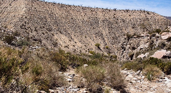
The top of Jackass Flat was once home to Cahuilla Indians.
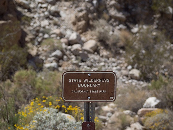
Rockhouse Canyon State Wilderness Boundary sign
Rockhouse Canyon may be the “Grand Canyon” of the Anza Borrego. It is a deep, narrow gash through high cliffs connecting Rockhouse Valley with Clark Valley. The colorful rock layers tell a story about many of the geological events that have occurred here over the past half-billion years. The area also contains several former Cahuilla villages, with many artifacts to remind us of the thousands of years they have lived here. Today it is one of the most remote, uninhabited places in the Anza-Borrego, a place to go if seeking solitude in addition to learning some human and natural history of the Anza-Borrego region.
The jeep road ends where the Anza-Borrego Wilderness area and the 10-mile hike officially begins at 12.5 miles from S-22. (No vehicles are allowed past this point even though older maps show the road continuing.) Most passenger vehicles driving carefully and slowly can make it as far as mile 9.3, just before the Butler Canyon–Rockhouse Canyon split is located. High-clearance vehicles may be able to go further, and 4WD vehicles can make it to the end of the road. Proceed east up wash if driving further.
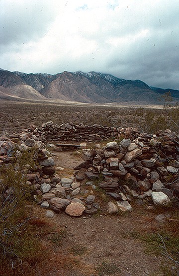
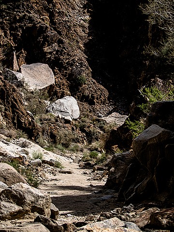
Ruins at the entrance to the valley
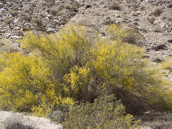
While traveling up the wash, look for smoke trees scattered among the large boulders, as well as burro bush, desert lavender, and the occasional brittlebush. Other shrubs to note in the wash and elsewhere in the canyon ahead include bladder pod, cheese bush, and desert willow. If exploring the canyon in the spring, look for occasional wildflowers, including Arizona lupine, ground cherry, cove senna, and trailing windmills.
Pause to note the 200 feet of unconsolidated alluvium rising above you, forming a near cliff on your left. Jackass Flat is at the top of the huge pile of sand and rocks that have eroded from Buck Ridge over the past several million years. This giant pile of alluvium awaits one or more of the infrequent flash floods to carry it down into Clark Valley in a violent cataclysm. At 13 miles from S-22 is Hidden Spring, found on a hillside below Jackass Flat. It is dry as a result of the current drought. In years past, there has been a small seep where thirsty bees have found a drink.
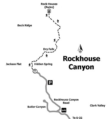
Map to Rockhouse Canyon
Continuing up the canyon, look for a grove of native blue palo verde trees on the left, a magnificent sight if there in early April when they are in full bloom. There are also numerous mesquite trees scattered throughout the canyon. Their protein-rich mesquite seeds were one of the main foods of the Cahuilla, who had a village in Jackass Flat.
Blue palo verde in bloom
Note the reddish-brown, desert-varnished rocks that make up the walls of the canyon here and for some distance up the canyon. These are the oldest rocks in the canyon, perhaps half a billion years old. They were first deposited as sediment at the bottom an ancient sea and then subjected to intense pressure and heat as a mountain range that preceded the Santa Rosas arose. Several types of metamorphic rock, including schist, quartzite, and marble are found here. The Santa Rosa Mountains are the result of more recent mountain-building, commencing about 7 to 10 million years ago when a mass of molten rock, called a pluton, rose from deep within the earth’s crust. As this granitic pluton arose, the overlying metamorphic rocks were elevated and fragmented.
Boulders within metamorphic rock
In another mile from Hidden Spring, begin looking for parts of the granitic pluton that continues elevating the Santa Rosa Mountains. The first sign of their presence is several enormous granite boulders, just before a granite outcrop that forms a dry fall, perhaps 20 feet high. It is fairly easy to climb around this massive wall, staying to the right. From this point, for the next 2.8 miles until entering Rockhouse Valley, hiking is mostly through soft sand.
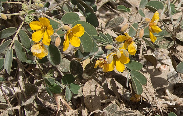
Cove senna
To see one group of rock-house ruins for which the canyon and valley is named, keep to the west side of the valley after entering Rockhouse Valley and hike about 0.6 mile to a ridge that extends to the valley floor. Then go another 0.2 mile north to find three rock houses on a hill overlooking the valley. Currently they are just rocks piled up to form a low circular wall but it is likely that the Cahuilla made roofs over these houses with branches and brush.
This may be as far as most people want to go on a day-hike, though there are several more rock houses in Rockhouse Valley, as well as other interesting things to see. However, water is scarce and the distances are long. These other sites are best left for a multi-day backpack trip. After exploring the valley entrance and the rock houses, turn around and head back to your vehicle.
Distance from downtown San Diego: 106 miles. Allow 2.5 hours driving time (Borrego Springs). From Christmas Circle, drive east on S-22, 7.7 miles to milepost 26.7. Turn north onto Rockhouse Canyon Road (RCR). The pavement ends shortly. From here on, for the next 12.5 miles, the RCR presents a series of difficulties that will determine distance driven. For the first 3.7 miles the RCR is a broad, gravel, washboard road with further distance driven dependent on rainfall when crossing the usually dry Clark Lake bed, where vehicles should stay on the road but could still become mired if muddy. At 5.2 miles from S-22, a road goes off to the right that ends at the former Clark Lake Radio Observatory, now posted “Authorized Vehicles Only.” Keep to the west (left) and drive to the end of the road if able — 4WD recommended to reach road end — or park before road end to begin the hike if vehicle clearance or obstacles become a problem. Note: backcountry towing is not covered by most insurance policies.
Hiking length: 10 miles out-and-back or longer, depending where parked.
Difficulty: Strenuous with about 2000 feet of elevation gain/loss. No facilities or water after leaving Christmas Circle in Borrego Springs. Hidden Spring is currently dry and not potable.
Here's something you might be interested in.
Begin where the jeep road ends
If it rains, look out for violent cataclysms in Clark Valley
Begin where the jeep road ends
If it rains, look out for violent cataclysms in Clark Valley
The top of Jackass Flat was once home to Cahuilla Indians.
Rockhouse Canyon State Wilderness Boundary sign
Rockhouse Canyon may be the “Grand Canyon” of the Anza Borrego. It is a deep, narrow gash through high cliffs connecting Rockhouse Valley with Clark Valley. The colorful rock layers tell a story about many of the geological events that have occurred here over the past half-billion years. The area also contains several former Cahuilla villages, with many artifacts to remind us of the thousands of years they have lived here. Today it is one of the most remote, uninhabited places in the Anza-Borrego, a place to go if seeking solitude in addition to learning some human and natural history of the Anza-Borrego region.
The jeep road ends where the Anza-Borrego Wilderness area and the 10-mile hike officially begins at 12.5 miles from S-22. (No vehicles are allowed past this point even though older maps show the road continuing.) Most passenger vehicles driving carefully and slowly can make it as far as mile 9.3, just before the Butler Canyon–Rockhouse Canyon split is located. High-clearance vehicles may be able to go further, and 4WD vehicles can make it to the end of the road. Proceed east up wash if driving further.
Ruins at the entrance to the valley
While traveling up the wash, look for smoke trees scattered among the large boulders, as well as burro bush, desert lavender, and the occasional brittlebush. Other shrubs to note in the wash and elsewhere in the canyon ahead include bladder pod, cheese bush, and desert willow. If exploring the canyon in the spring, look for occasional wildflowers, including Arizona lupine, ground cherry, cove senna, and trailing windmills.
Pause to note the 200 feet of unconsolidated alluvium rising above you, forming a near cliff on your left. Jackass Flat is at the top of the huge pile of sand and rocks that have eroded from Buck Ridge over the past several million years. This giant pile of alluvium awaits one or more of the infrequent flash floods to carry it down into Clark Valley in a violent cataclysm. At 13 miles from S-22 is Hidden Spring, found on a hillside below Jackass Flat. It is dry as a result of the current drought. In years past, there has been a small seep where thirsty bees have found a drink.
Map to Rockhouse Canyon
Continuing up the canyon, look for a grove of native blue palo verde trees on the left, a magnificent sight if there in early April when they are in full bloom. There are also numerous mesquite trees scattered throughout the canyon. Their protein-rich mesquite seeds were one of the main foods of the Cahuilla, who had a village in Jackass Flat.
Blue palo verde in bloom
Note the reddish-brown, desert-varnished rocks that make up the walls of the canyon here and for some distance up the canyon. These are the oldest rocks in the canyon, perhaps half a billion years old. They were first deposited as sediment at the bottom an ancient sea and then subjected to intense pressure and heat as a mountain range that preceded the Santa Rosas arose. Several types of metamorphic rock, including schist, quartzite, and marble are found here. The Santa Rosa Mountains are the result of more recent mountain-building, commencing about 7 to 10 million years ago when a mass of molten rock, called a pluton, rose from deep within the earth’s crust. As this granitic pluton arose, the overlying metamorphic rocks were elevated and fragmented.
Boulders within metamorphic rock
In another mile from Hidden Spring, begin looking for parts of the granitic pluton that continues elevating the Santa Rosa Mountains. The first sign of their presence is several enormous granite boulders, just before a granite outcrop that forms a dry fall, perhaps 20 feet high. It is fairly easy to climb around this massive wall, staying to the right. From this point, for the next 2.8 miles until entering Rockhouse Valley, hiking is mostly through soft sand.
Cove senna
To see one group of rock-house ruins for which the canyon and valley is named, keep to the west side of the valley after entering Rockhouse Valley and hike about 0.6 mile to a ridge that extends to the valley floor. Then go another 0.2 mile north to find three rock houses on a hill overlooking the valley. Currently they are just rocks piled up to form a low circular wall but it is likely that the Cahuilla made roofs over these houses with branches and brush.
This may be as far as most people want to go on a day-hike, though there are several more rock houses in Rockhouse Valley, as well as other interesting things to see. However, water is scarce and the distances are long. These other sites are best left for a multi-day backpack trip. After exploring the valley entrance and the rock houses, turn around and head back to your vehicle.
Distance from downtown San Diego: 106 miles. Allow 2.5 hours driving time (Borrego Springs). From Christmas Circle, drive east on S-22, 7.7 miles to milepost 26.7. Turn north onto Rockhouse Canyon Road (RCR). The pavement ends shortly. From here on, for the next 12.5 miles, the RCR presents a series of difficulties that will determine distance driven. For the first 3.7 miles the RCR is a broad, gravel, washboard road with further distance driven dependent on rainfall when crossing the usually dry Clark Lake bed, where vehicles should stay on the road but could still become mired if muddy. At 5.2 miles from S-22, a road goes off to the right that ends at the former Clark Lake Radio Observatory, now posted “Authorized Vehicles Only.” Keep to the west (left) and drive to the end of the road if able — 4WD recommended to reach road end — or park before road end to begin the hike if vehicle clearance or obstacles become a problem. Note: backcountry towing is not covered by most insurance policies.
Hiking length: 10 miles out-and-back or longer, depending where parked.
Difficulty: Strenuous with about 2000 feet of elevation gain/loss. No facilities or water after leaving Christmas Circle in Borrego Springs. Hidden Spring is currently dry and not potable.