Here's something you might be interested in.
Ask a Hipster — Advice you didn't know you needed
Big Screen — Movie commentary
Blurt — Music's inside track
Booze News — San Diego spirits
Classical Music — Immortal beauty
Classifieds — Free and easy
Close to Home — What it’s like on the street where you live
Cover Stories — Front-page features
Drinks All Around — Bartenders' drink recipes
Excerpts — Literary and spiritual excerpts
Feast! — Food & drink reviews
Feature Stories — Local news & stories
Fishing Report — What’s getting hooked from ship and shore
From the Archives — Spotlight on the past
Golden Dreams — Talk of the town
The Gonzo Report — Making the musical scene, or at least reporting from it
Letters — Our inbox
Movies@Home — Local movie buffs share favorites
Movie Reviews — Our critics' picks and pans
Musician Interviews — Up close with local artists
Neighborhood News from Stringers — Hyperlocal news
News Ticker — News & politics
Obermeyer — San Diego politics illustrated
Outdoors — Weekly changes in flora and fauna
Overheard in San Diego — Eavesdropping illustrated
Poetry — The old and the new
Reader Travel — Travel section built by travelers
Reading — The hunt for intellectuals
Roam-O-Rama — SoCal's best hiking/biking trails
San Diego Beer — Inside San Diego suds
SD on the QT — Almost factual news
Sheep and Goats — Places of worship
Special Issues — The best of
Street Style — San Diego streets have style
Surf Diego — Real stories from those braving the waves
Theater — On stage in San Diego this week
Tin Fork — Silver spoon alternative
Under the Radar — Matt Potter's undercover work
Unforgettable — Long-ago San Diego
Unreal Estate — San Diego's priciest pads
Your Week — Daily event picks
Find your way to the woodland
This popular hike leads to a pinyon forest and spectacular views.
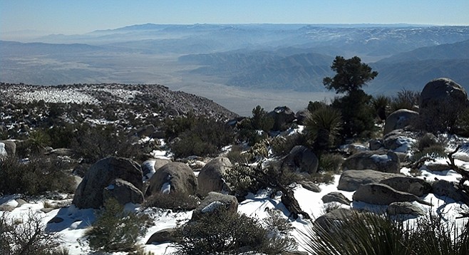
Looking to the south toward Agua Caliente County Park from the top of Whale Peak.
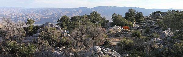
The top of Whale Peak makes a fabulous overnight campsite.
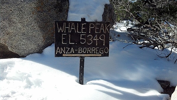
Whale Peak, though not the highest peak in the Anza-Borrego Desert State Park, is high enough at 5349 feet to offer spectacular views of much of the park and beyond to mountain ranges in Mexico and Arizona. It is also high enough to support an extensive pinyon–juniper woodland, a beautiful forest of miniature trees.
At mile 5.7, start hiking up the steep, boulder-choked canyon straight ahead. Consistently look back for landmarks while climbing around and over boulders where there will be only occasional stacked rocks (ducks) to mark the path. After climbing for about a quarter of a mile, there will be a sandy flat. Starting at this point, there will be an obvious path created by hundreds of other hikers who have ventured up the mountain. Although marked with frequent ducks, don’t rely too much on them, as there are numerous other routes going in different directions, also marked with ducks. This hike offers an excellent opportunity to practice route-finding skills.
Whale Peak
There are three more ridges to climb before reaching a point where the final ascent to the top of the broad, relatively flat, Whale Peak begins. Explore the peak area to find the best vantage points to view the Salton Sea to the east, Agua Caliente County Park to the west at over 4000 feet below, and northeast to the Borrego Valley, the Santa Rosa Mountains, and beyond to Mt. San Jacinto.
Although the views are inspiring, be sure to take some time to observe the variety of plant life in this juniper-pinyon woodland. In addition to the single–leafed pinyon pine and California juniper, you will also find scrub oak, huge Mojave yuccas, an abundance of silver cholla, as well as the occasional beaver tail cactus, and desert apricot. The Kumeyaay Indians collected pinyon nuts in late summer.
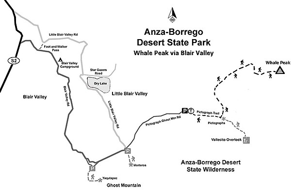
Whale Peak via Blair Valley
Once you have explored the peak area, return to your car the way you came. Be careful when selecting a route based on ducks or you could end up many miles from your vehicle. It can be helpful to turn around and look for landmarks noted on the way up — most trails look different on the return!
Note: This hike is best done from October through May, with the best chance of finding blooming wildflowers in March or early April. Map and compass or GPS are recommended for route finding. A 4WD vehicle and trekking poles are recommended.
Distance from downtown San Diego: About 84 miles. Allow 2 hours driving time (Shelter Valley). From Julian, travel east on SR-78 for about 12 miles down Banner Grade to Scissors Crossing, then go south on SR-2 for 4.9 miles and turn east onto the signed Pinyon Mountain Road (PMR). Almost immediately the dirt road splits, so keep going east for 5.7 miles over areas of deep soft sand, bumps, deep ruts, and rocks, and park where there is a short spur road going off to the south toward Whale Peak. Be sure to note your mileage after turning onto PMR, as there are similar spur roads going toward Whale Peak at 4.1 and 6.3 miles from the SR-2. All three have been used as starting points but the route starting at mile 5.7 is the most frequently used to Whale Peak (and the one described here).
Hiking length: 4 miles out and back.
Difficulty: Moderately strenuous with an elevation gain/loss of 1500 feet. Dogs and mountain bikers not allowed. No facilities or water.
Here's something you might be interested in.
Find your way to the woodland
This popular hike leads to a pinyon forest and spectacular views.
Find your way to the woodland
This popular hike leads to a pinyon forest and spectacular views.
Looking to the south toward Agua Caliente County Park from the top of Whale Peak.
The top of Whale Peak makes a fabulous overnight campsite.
Whale Peak, though not the highest peak in the Anza-Borrego Desert State Park, is high enough at 5349 feet to offer spectacular views of much of the park and beyond to mountain ranges in Mexico and Arizona. It is also high enough to support an extensive pinyon–juniper woodland, a beautiful forest of miniature trees.
At mile 5.7, start hiking up the steep, boulder-choked canyon straight ahead. Consistently look back for landmarks while climbing around and over boulders where there will be only occasional stacked rocks (ducks) to mark the path. After climbing for about a quarter of a mile, there will be a sandy flat. Starting at this point, there will be an obvious path created by hundreds of other hikers who have ventured up the mountain. Although marked with frequent ducks, don’t rely too much on them, as there are numerous other routes going in different directions, also marked with ducks. This hike offers an excellent opportunity to practice route-finding skills.
Whale Peak
There are three more ridges to climb before reaching a point where the final ascent to the top of the broad, relatively flat, Whale Peak begins. Explore the peak area to find the best vantage points to view the Salton Sea to the east, Agua Caliente County Park to the west at over 4000 feet below, and northeast to the Borrego Valley, the Santa Rosa Mountains, and beyond to Mt. San Jacinto.
Although the views are inspiring, be sure to take some time to observe the variety of plant life in this juniper-pinyon woodland. In addition to the single–leafed pinyon pine and California juniper, you will also find scrub oak, huge Mojave yuccas, an abundance of silver cholla, as well as the occasional beaver tail cactus, and desert apricot. The Kumeyaay Indians collected pinyon nuts in late summer.
Whale Peak via Blair Valley
Once you have explored the peak area, return to your car the way you came. Be careful when selecting a route based on ducks or you could end up many miles from your vehicle. It can be helpful to turn around and look for landmarks noted on the way up — most trails look different on the return!
Note: This hike is best done from October through May, with the best chance of finding blooming wildflowers in March or early April. Map and compass or GPS are recommended for route finding. A 4WD vehicle and trekking poles are recommended.
Distance from downtown San Diego: About 84 miles. Allow 2 hours driving time (Shelter Valley). From Julian, travel east on SR-78 for about 12 miles down Banner Grade to Scissors Crossing, then go south on SR-2 for 4.9 miles and turn east onto the signed Pinyon Mountain Road (PMR). Almost immediately the dirt road splits, so keep going east for 5.7 miles over areas of deep soft sand, bumps, deep ruts, and rocks, and park where there is a short spur road going off to the south toward Whale Peak. Be sure to note your mileage after turning onto PMR, as there are similar spur roads going toward Whale Peak at 4.1 and 6.3 miles from the SR-2. All three have been used as starting points but the route starting at mile 5.7 is the most frequently used to Whale Peak (and the one described here).
Hiking length: 4 miles out and back.
Difficulty: Moderately strenuous with an elevation gain/loss of 1500 feet. Dogs and mountain bikers not allowed. No facilities or water.