Here's something you might be interested in.
Ask a Hipster — Advice you didn't know you needed
Big Screen — Movie commentary
Blurt — Music's inside track
Booze News — San Diego spirits
Classical Music — Immortal beauty
Classifieds — Free and easy
Cover Stories — Front-page features
Drinks All Around — Bartenders' drink recipes
Excerpts — Literary and spiritual excerpts
Feast! — Food & drink reviews
Feature Stories — Local news & stories
Fishing Report — What’s getting hooked from ship and shore
From the Archives — Spotlight on the past
Golden Dreams — Talk of the town
The Gonzo Report — Making the musical scene, or at least reporting from it
Letters — Our inbox
Movies@Home — Local movie buffs share favorites
Movie Reviews — Our critics' picks and pans
Musician Interviews — Up close with local artists
Neighborhood News from Stringers — Hyperlocal news
News Ticker — News & politics
Obermeyer — San Diego politics illustrated
Outdoors — Weekly changes in flora and fauna
Overheard in San Diego — Eavesdropping illustrated
Poetry — The old and the new
Reader Travel — Travel section built by travelers
Reading — The hunt for intellectuals
Roam-O-Rama — SoCal's best hiking/biking trails
San Diego Beer — Inside San Diego suds
SD on the QT — Almost factual news
Sheep and Goats — Places of worship
Special Issues — The best of
Street Style — San Diego streets have style
Surf Diego — Real stories from those braving the waves
Theater — On stage in San Diego this week
Tin Fork — Silver spoon alternative
Under the Radar — Matt Potter's undercover work
Unforgettable — Long-ago San Diego
Unreal Estate — San Diego's priciest pads
Your Week — Daily event picks
Lake Cuyamaca loop
Cuyamaca is a Spanish corruption of the Kumeyaay phrase “Ekwiiyemak”
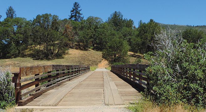
The bridge that leads to the lake
Lake Cuyamaca sits at an elevation of 4600 feet in an oak and pine forest, surrounded on three sides by the 26,000-acre Cuyamaca Rancho State Park. The dam that forms this 110-acre lake is the second oldest in California and was completed in 1888. A long-vanished 33-mile wooden flume transported water to the growing population of San Diego County. Now owned by the Helix Water District, the lake provides a multitude of recreational activities, including fishing, camping, and hiking. The name Cuyamaca is a Spanish corruption of the Kumeyaay phrase “Ekwiiyemak,” which has been translated to mean “behind the clouds” or as “the place where it rains,” alluding to the higher-than-average rainfall experienced here as compared to the dryer coastal regions of the county.
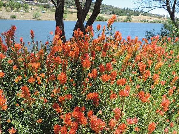
Indian paintbrush found along the lake trail
This area has a variety of large mammals to be on the lookout for, including mule deer, mountain lion, bobcat, and coyote; smaller mammals include ground squirrels, voles, pocket mice, and bats. The western gray squirrel, once plentiful, has been on the decline in recent years but the cause remains a mystery. Over 220 species of birds have been reported here. Red-winged blackbirds, named for the red chevron seen on their wings in flight, can usually be found in the reeds along the edge of the lake. Shore birds, such as terns, great and snowy egrets, and great blue herons, can be observed patrolling the lake for a fish dinner. While not native to the area, there is a thriving population of wild turkeys, introduced in 1994, that are a common sight in the meadows or crossing the trail. Other bird species likely to be seen are acorn woodpeckers, western bluebirds, and northern flickers.
Begin the hike at the Trout Pond Trailhead, noting that there is actually no Trout Pond Trail, but rather three trails (Minshall, Los Vaqueros, and Los Caballos) that begin at or near this location. When the lake’s level is as low as it is, a loop completely around the lake is feasible and rewarding.
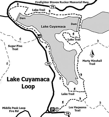
Start on the Marty Minshall/Los Vaqueros Trail that skirts to the south of a large meadow at the edge of the lake. Much of this meadow will be submerged in wetter years. This is also the northern boundary of the Cuyamaca Meadows Natural Preserve, which was established to protect a number of sensitive plant species, including Lake Cuyamaca downingia, Parish’s meadowfoam, and Cuyamaca larkspur. Keep straight on the Minshall Trail, as it intersects with the Los Caballos Trail (heading toward the Los Caballos Horse Camp) at about 0.4 mile. At just under 1 mile there will be a trail marker on the right for the Stonewall Mine. In a wet year this would make a fine alternative hike over to the mine. For now, however, look to the left. Look for a narrow opening through the fence that leads toward the lake and onto the Lake Trail. Cross over a bridge and begin the loop around the lake. Turn right after the bridge for a slightly shorter walk or turn left for an additional 0.4 mile to walk under the shade of mature oak and pine trees. Keep alert for an imposing wooden sculpture of a bear (a must photo op). After crossing over the eastern boundary of the lake, the trail will follow along the northern shore and past Chambers Park and Lone Pine Camp. As the restricted area of the dam is approached, turn right and follow the trail north and then west to SR-79. Walk about 300 yards beside the road until the dam is passed, and then drop down to the shore to continue the hike. This is a good section of the lake to pause for a snack or light lunch before continuing on to the east and passing through the meadow once again to arrive back at the Minshall Trail. Retrace your route for 0.5 mile to return to your vehicle at the trailhead.
- Distance from downtown San Diego: 53 miles. Allow 1 hour driving time (Cuyamaca). Take CA-163N and merge on I-8E. Drive 38 miles, exit on SR-79, and turn north/left on SR-79. Drive 2.7 miles and turn left to stay on SR-79N and drive 10.7 miles. Park in the Trout Pond staging area on the right, just before the road takes a sharp right turn before reaching the lake.
- Hours: dawn to dusk.
- Phone Number: 760-765-0515.
- Hiking length: 5-mile loop.
- Difficulty: Easy, with about 100 feet elevation gain/loss. Hikers, equestrians, and dogs (on leashes) are allowed. Facilities.
Here's something you might be interested in.
Lake Cuyamaca loop
Cuyamaca is a Spanish corruption of the Kumeyaay phrase “Ekwiiyemak”
Lake Cuyamaca loop
Cuyamaca is a Spanish corruption of the Kumeyaay phrase “Ekwiiyemak”
The bridge that leads to the lake
Lake Cuyamaca sits at an elevation of 4600 feet in an oak and pine forest, surrounded on three sides by the 26,000-acre Cuyamaca Rancho State Park. The dam that forms this 110-acre lake is the second oldest in California and was completed in 1888. A long-vanished 33-mile wooden flume transported water to the growing population of San Diego County. Now owned by the Helix Water District, the lake provides a multitude of recreational activities, including fishing, camping, and hiking. The name Cuyamaca is a Spanish corruption of the Kumeyaay phrase “Ekwiiyemak,” which has been translated to mean “behind the clouds” or as “the place where it rains,” alluding to the higher-than-average rainfall experienced here as compared to the dryer coastal regions of the county.
Indian paintbrush found along the lake trail
This area has a variety of large mammals to be on the lookout for, including mule deer, mountain lion, bobcat, and coyote; smaller mammals include ground squirrels, voles, pocket mice, and bats. The western gray squirrel, once plentiful, has been on the decline in recent years but the cause remains a mystery. Over 220 species of birds have been reported here. Red-winged blackbirds, named for the red chevron seen on their wings in flight, can usually be found in the reeds along the edge of the lake. Shore birds, such as terns, great and snowy egrets, and great blue herons, can be observed patrolling the lake for a fish dinner. While not native to the area, there is a thriving population of wild turkeys, introduced in 1994, that are a common sight in the meadows or crossing the trail. Other bird species likely to be seen are acorn woodpeckers, western bluebirds, and northern flickers.
Begin the hike at the Trout Pond Trailhead, noting that there is actually no Trout Pond Trail, but rather three trails (Minshall, Los Vaqueros, and Los Caballos) that begin at or near this location. When the lake’s level is as low as it is, a loop completely around the lake is feasible and rewarding.
Start on the Marty Minshall/Los Vaqueros Trail that skirts to the south of a large meadow at the edge of the lake. Much of this meadow will be submerged in wetter years. This is also the northern boundary of the Cuyamaca Meadows Natural Preserve, which was established to protect a number of sensitive plant species, including Lake Cuyamaca downingia, Parish’s meadowfoam, and Cuyamaca larkspur. Keep straight on the Minshall Trail, as it intersects with the Los Caballos Trail (heading toward the Los Caballos Horse Camp) at about 0.4 mile. At just under 1 mile there will be a trail marker on the right for the Stonewall Mine. In a wet year this would make a fine alternative hike over to the mine. For now, however, look to the left. Look for a narrow opening through the fence that leads toward the lake and onto the Lake Trail. Cross over a bridge and begin the loop around the lake. Turn right after the bridge for a slightly shorter walk or turn left for an additional 0.4 mile to walk under the shade of mature oak and pine trees. Keep alert for an imposing wooden sculpture of a bear (a must photo op). After crossing over the eastern boundary of the lake, the trail will follow along the northern shore and past Chambers Park and Lone Pine Camp. As the restricted area of the dam is approached, turn right and follow the trail north and then west to SR-79. Walk about 300 yards beside the road until the dam is passed, and then drop down to the shore to continue the hike. This is a good section of the lake to pause for a snack or light lunch before continuing on to the east and passing through the meadow once again to arrive back at the Minshall Trail. Retrace your route for 0.5 mile to return to your vehicle at the trailhead.
- Distance from downtown San Diego: 53 miles. Allow 1 hour driving time (Cuyamaca). Take CA-163N and merge on I-8E. Drive 38 miles, exit on SR-79, and turn north/left on SR-79. Drive 2.7 miles and turn left to stay on SR-79N and drive 10.7 miles. Park in the Trout Pond staging area on the right, just before the road takes a sharp right turn before reaching the lake.
- Hours: dawn to dusk.
- Phone Number: 760-765-0515.
- Hiking length: 5-mile loop.
- Difficulty: Easy, with about 100 feet elevation gain/loss. Hikers, equestrians, and dogs (on leashes) are allowed. Facilities.