Here's something you might be interested in.
Ask a Hipster — Advice you didn't know you needed
Big Screen — Movie commentary
Blurt — Music's inside track
Booze News — San Diego spirits
Classical Music — Immortal beauty
Classifieds — Free and easy
Cover Stories — Front-page features
Drinks All Around — Bartenders' drink recipes
Excerpts — Literary and spiritual excerpts
Feast! — Food & drink reviews
Feature Stories — Local news & stories
Fishing Report — What’s getting hooked from ship and shore
From the Archives — Spotlight on the past
Golden Dreams — Talk of the town
The Gonzo Report — Making the musical scene, or at least reporting from it
Letters — Our inbox
Movies@Home — Local movie buffs share favorites
Movie Reviews — Our critics' picks and pans
Musician Interviews — Up close with local artists
Neighborhood News from Stringers — Hyperlocal news
News Ticker — News & politics
Obermeyer — San Diego politics illustrated
Outdoors — Weekly changes in flora and fauna
Overheard in San Diego — Eavesdropping illustrated
Poetry — The old and the new
Reader Travel — Travel section built by travelers
Reading — The hunt for intellectuals
Roam-O-Rama — SoCal's best hiking/biking trails
San Diego Beer — Inside San Diego suds
SD on the QT — Almost factual news
Sheep and Goats — Places of worship
Special Issues — The best of
Street Style — San Diego streets have style
Surf Diego — Real stories from those braving the waves
Theater — On stage in San Diego this week
Tin Fork — Silver spoon alternative
Under the Radar — Matt Potter's undercover work
Unforgettable — Long-ago San Diego
Unreal Estate — San Diego's priciest pads
Your Week — Daily event picks
One of La Jolla’s best-kept secrets revealed
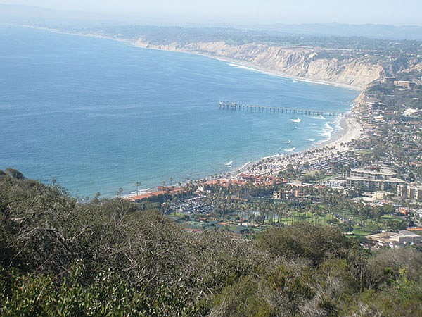
The view is a sweeping panorama of the La Jolla shoreline.
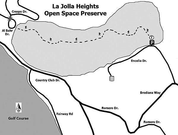
One of La Jolla’s best-kept secrets is a small 42-acre open space preserve called La Jolla Heights that is managed by the City of San Diego’s Parks and Recreation Department. The area was set aside to preserve highly sensitive biological resources of the coastal mixed chaparral habitat. The thick vegetation of this habitat provides valuable food for wildlife. Typical wildlife found here include grey fox, bobcat, brush rabbit, wood rat, spotted skunk, alligator lizard, rattlesnake, gopher snake, scrub jay, and wrentit.
Encelia Dr. terminates at the summit of La Jolla Open Space Preserve. The trail begins to the left of the easement. A small succulent garden surrounds the summit where the trail begins. Agaves dominate the scene with their large lance-like leaves. At the downhill side of the garden is a sitting bench that provides a 180-degree view of the La Jolla area and the turquoise waters of the Pacific Ocean beyond. La Jolla Shores and Torrey Pines State Reserve is especially beautiful, so select a clear day for this hike to take advantage of the views. Spend time taking in the spectacular vista before beginning your descent along the trail.
The narrow trail winds its way downhill through chamise and scrub oak. The low-lying vegetation provides opportunities for more views along the way. Chamise is a common native plant of coastal sage and chaparral plant communities. It is prevalent here and is identified by its tiny bundled leaves. In the springtime the area will come alive with bouquets of delicate creamy blossoms. The plant does well in dry conditions. The new stems grow straight upward, presenting less surface area to the sun. This and the small leaf structure create a design, well suited for conserving water. The Native Americans used this plant to make the fore shaft of their arrows due to the straightness of the plant structure.
On the way down the trail, note the many rounded cobblestones. The rocky trail surface can be challenging for hikers in some places. These stones are part of our geological history. They were worn smooth in rivers and traveled north from Mexico through movement of tectonic plates, millions of years ago. Our coastal land is still moving to the north about an inch a year.
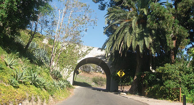
Heading downhill there will be several trails that meander through the chaparral. In warmer weather, lizards may be sighted darting in and out of the brush along the way. A small side-canyon will appear on the left as the trail heads down. From here, a line of taller bushes will be visible along the left-hand side. Listen for bird calls from this location. Continue downhill, keeping the tree line to the left. There is a small riparian area and a bridge at the bottom of the trail, which borders a La Jolla Neighborhood near Cowrie Ave.
On the way back, there is the option of taking the wide access road to the left near the top. The wide road leads straight uphill to merge with Encelia Drive, where the trek began. There is a variety of tall shrubs along the roadside that include chaparral broom, fennel, and toyon. Toyon has long, oval, gently saw-toothed leaves and develops bright red berries during the winter months. These berries were cooked by the Native Americans and are favored by wintering birds. Looking off across the vegetation in this area gives a good perspective on how dense these plants can grow, making passage difficult.
Note that this trek can also begin at the bottom of the hill leading to the summit and returning downhill. However, parking is limited at the bottom and may require walking a distance to begin the hike from the bottom.
La Jolla Heights Open Space Preserve
- Distance from downtown San Diego: About 15 miles. Allow 22 minutes (La Jolla). Take I-5 N to the La Jolla Parkway exit. Follow La Jolla Parkway and turn left onto Torrey Pines Rd. and proceed to Exchange Place. Turn left on Exchange Place, then right onto Country Club Dr. Take a left on Romero Dr. and another left on Brodiaea Way. If available, park on the corner of Brodiaea Way and Encelia Drive. (Parking is very limited.) Walk up Encelia Dr. for the trailhead.
- Hiking length: 1 mile out and back.
- Difficulty: Moderately steep. Elevation gain/loss total 400 feet. No facilities.
Here's something you might be interested in.
One of La Jolla’s best-kept secrets revealed
One of La Jolla’s best-kept secrets revealed
The view is a sweeping panorama of the La Jolla shoreline.
One of La Jolla’s best-kept secrets is a small 42-acre open space preserve called La Jolla Heights that is managed by the City of San Diego’s Parks and Recreation Department. The area was set aside to preserve highly sensitive biological resources of the coastal mixed chaparral habitat. The thick vegetation of this habitat provides valuable food for wildlife. Typical wildlife found here include grey fox, bobcat, brush rabbit, wood rat, spotted skunk, alligator lizard, rattlesnake, gopher snake, scrub jay, and wrentit.
Encelia Dr. terminates at the summit of La Jolla Open Space Preserve. The trail begins to the left of the easement. A small succulent garden surrounds the summit where the trail begins. Agaves dominate the scene with their large lance-like leaves. At the downhill side of the garden is a sitting bench that provides a 180-degree view of the La Jolla area and the turquoise waters of the Pacific Ocean beyond. La Jolla Shores and Torrey Pines State Reserve is especially beautiful, so select a clear day for this hike to take advantage of the views. Spend time taking in the spectacular vista before beginning your descent along the trail.
The narrow trail winds its way downhill through chamise and scrub oak. The low-lying vegetation provides opportunities for more views along the way. Chamise is a common native plant of coastal sage and chaparral plant communities. It is prevalent here and is identified by its tiny bundled leaves. In the springtime the area will come alive with bouquets of delicate creamy blossoms. The plant does well in dry conditions. The new stems grow straight upward, presenting less surface area to the sun. This and the small leaf structure create a design, well suited for conserving water. The Native Americans used this plant to make the fore shaft of their arrows due to the straightness of the plant structure.
On the way down the trail, note the many rounded cobblestones. The rocky trail surface can be challenging for hikers in some places. These stones are part of our geological history. They were worn smooth in rivers and traveled north from Mexico through movement of tectonic plates, millions of years ago. Our coastal land is still moving to the north about an inch a year.
Heading downhill there will be several trails that meander through the chaparral. In warmer weather, lizards may be sighted darting in and out of the brush along the way. A small side-canyon will appear on the left as the trail heads down. From here, a line of taller bushes will be visible along the left-hand side. Listen for bird calls from this location. Continue downhill, keeping the tree line to the left. There is a small riparian area and a bridge at the bottom of the trail, which borders a La Jolla Neighborhood near Cowrie Ave.
On the way back, there is the option of taking the wide access road to the left near the top. The wide road leads straight uphill to merge with Encelia Drive, where the trek began. There is a variety of tall shrubs along the roadside that include chaparral broom, fennel, and toyon. Toyon has long, oval, gently saw-toothed leaves and develops bright red berries during the winter months. These berries were cooked by the Native Americans and are favored by wintering birds. Looking off across the vegetation in this area gives a good perspective on how dense these plants can grow, making passage difficult.
Note that this trek can also begin at the bottom of the hill leading to the summit and returning downhill. However, parking is limited at the bottom and may require walking a distance to begin the hike from the bottom.
La Jolla Heights Open Space Preserve
- Distance from downtown San Diego: About 15 miles. Allow 22 minutes (La Jolla). Take I-5 N to the La Jolla Parkway exit. Follow La Jolla Parkway and turn left onto Torrey Pines Rd. and proceed to Exchange Place. Turn left on Exchange Place, then right onto Country Club Dr. Take a left on Romero Dr. and another left on Brodiaea Way. If available, park on the corner of Brodiaea Way and Encelia Drive. (Parking is very limited.) Walk up Encelia Dr. for the trailhead.
- Hiking length: 1 mile out and back.
- Difficulty: Moderately steep. Elevation gain/loss total 400 feet. No facilities.