Here's something you might be interested in.
Ask a Hipster — Advice you didn't know you needed
Big Screen — Movie commentary
Blurt — Music's inside track
Booze News — San Diego spirits
Classical Music — Immortal beauty
Classifieds — Free and easy
Cover Stories — Front-page features
Drinks All Around — Bartenders' drink recipes
Excerpts — Literary and spiritual excerpts
Feast! — Food & drink reviews
Feature Stories — Local news & stories
Fishing Report — What’s getting hooked from ship and shore
From the Archives — Spotlight on the past
Golden Dreams — Talk of the town
The Gonzo Report — Making the musical scene, or at least reporting from it
Letters — Our inbox
Movies@Home — Local movie buffs share favorites
Movie Reviews — Our critics' picks and pans
Musician Interviews — Up close with local artists
Neighborhood News from Stringers — Hyperlocal news
News Ticker — News & politics
Obermeyer — San Diego politics illustrated
Outdoors — Weekly changes in flora and fauna
Overheard in San Diego — Eavesdropping illustrated
Poetry — The old and the new
Reader Travel — Travel section built by travelers
Reading — The hunt for intellectuals
Roam-O-Rama — SoCal's best hiking/biking trails
San Diego Beer — Inside San Diego suds
SD on the QT — Almost factual news
Sheep and Goats — Places of worship
Special Issues — The best of
Street Style — San Diego streets have style
Surf Diego — Real stories from those braving the waves
Theater — On stage in San Diego this week
Tin Fork — Silver spoon alternative
Under the Radar — Matt Potter's undercover work
Unforgettable — Long-ago San Diego
Unreal Estate — San Diego's priciest pads
Your Week — Daily event picks
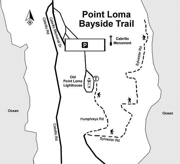
Cabrillo National Monument's Bayside Trail
Cabrillo National Monument’s Bayside Trail offers views that stretch into Mexico and out to the Cuyamaca Mountains, plus up-close viewing of pit-stopping migratory birds.
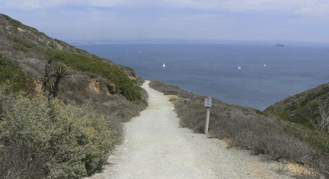
The view from the Bayside Trail at Cabrillo National Monument is stunningly beautiful. Visible from this trail are downtown San Diego, Coronado, San Diego Bay, and the Pacific Ocean. Whether you are visiting San Diego for the first time or are a lifelong San Diegan who has never made it all the way down Point Loma, this trail is a wonderful way to learn a little bit about the nature and history of the area. The trail is perfect for all ages and hiking abilities since it is a scant 1.86 miles round trip. But don’t be fooled by the length. It is still a good workout, as the hike back up the trail is all uphill with a 340-foot elevation gain.
There are interpretive signs along the trail identifying many of the common plants that may be seen on the hike. The signs also highlight the natural history and military importance of Point Loma and San Diego Bay and provide a good opportunity to take a break while climbing the slope back up.
The Bayside Trail is a perfect way to get acquainted with the coastal sage scrub ecosystem. This special habitat is becoming increasingly rare due to development in Southern California. On this trail, however, one can experience the plants and animals that call the sage scrub habitat home. Black sage, California sunflower, California sagebrush, laurel sumac, and lemonade berry are some of the common plants that are encountered. The best time to view wildflowers in this sage scrub community is February through May.
Point Loma is an important avian stopover on the Pacific Flyway. This means that during the spring and fall migration there are lots of bird species that may be viewed, many of which do not make their home in San Diego during the rest of the year. So, be sure to bring your binoculars! Binoculars are also helpful when viewing the marine birds just offshore and the occasional sea lion that swims up to the fishing boats below.
For history buffs, the Bayside Trail winds past several military bunkers that were part of the defense system used to protect San Diego Bay during World Wars I and II. Point Loma is still important to the military and the entrance to the monument is on land belonging to the Department of the Navy. Pay attention to the time while on the trail. The National Monument closes at 4 p.m. and the exit gate through the military base closes at 5 p.m. Leave time to explore the visitor center to learn about Juan Rodríguez Cabrillo, who discovered San Diego Bay in 1542.
Distance from downtown San Diego: 15 miles. Allow 26 minutes. Take SR-163 north to I-8 west. Turn left on Sunset Cliffs Blvd. at the end of the freeway. Drive 0.6 mile, turn left on Voltaire Street, and then right on Catalina Blvd. after 0.7 mile. After 2.7 miles, merge with Cabrillo Memorial Drive and follow it 2.5 miles to the monument. Entrance fee or National Parks Pass required. Facilities.
Hiking length: 1.86 miles round trip.
Difficulty: Easy. Elevation loss/gain of 340 feet.
Here's something you might be interested in.
Cabrillo National Monument's Bayside Trail
Cabrillo National Monument's Bayside Trail
Cabrillo National Monument’s Bayside Trail offers views that stretch into Mexico and out to the Cuyamaca Mountains, plus up-close viewing of pit-stopping migratory birds.
The view from the Bayside Trail at Cabrillo National Monument is stunningly beautiful. Visible from this trail are downtown San Diego, Coronado, San Diego Bay, and the Pacific Ocean. Whether you are visiting San Diego for the first time or are a lifelong San Diegan who has never made it all the way down Point Loma, this trail is a wonderful way to learn a little bit about the nature and history of the area. The trail is perfect for all ages and hiking abilities since it is a scant 1.86 miles round trip. But don’t be fooled by the length. It is still a good workout, as the hike back up the trail is all uphill with a 340-foot elevation gain.
There are interpretive signs along the trail identifying many of the common plants that may be seen on the hike. The signs also highlight the natural history and military importance of Point Loma and San Diego Bay and provide a good opportunity to take a break while climbing the slope back up.
The Bayside Trail is a perfect way to get acquainted with the coastal sage scrub ecosystem. This special habitat is becoming increasingly rare due to development in Southern California. On this trail, however, one can experience the plants and animals that call the sage scrub habitat home. Black sage, California sunflower, California sagebrush, laurel sumac, and lemonade berry are some of the common plants that are encountered. The best time to view wildflowers in this sage scrub community is February through May.
Point Loma is an important avian stopover on the Pacific Flyway. This means that during the spring and fall migration there are lots of bird species that may be viewed, many of which do not make their home in San Diego during the rest of the year. So, be sure to bring your binoculars! Binoculars are also helpful when viewing the marine birds just offshore and the occasional sea lion that swims up to the fishing boats below.
For history buffs, the Bayside Trail winds past several military bunkers that were part of the defense system used to protect San Diego Bay during World Wars I and II. Point Loma is still important to the military and the entrance to the monument is on land belonging to the Department of the Navy. Pay attention to the time while on the trail. The National Monument closes at 4 p.m. and the exit gate through the military base closes at 5 p.m. Leave time to explore the visitor center to learn about Juan Rodríguez Cabrillo, who discovered San Diego Bay in 1542.
Distance from downtown San Diego: 15 miles. Allow 26 minutes. Take SR-163 north to I-8 west. Turn left on Sunset Cliffs Blvd. at the end of the freeway. Drive 0.6 mile, turn left on Voltaire Street, and then right on Catalina Blvd. after 0.7 mile. After 2.7 miles, merge with Cabrillo Memorial Drive and follow it 2.5 miles to the monument. Entrance fee or National Parks Pass required. Facilities.
Hiking length: 1.86 miles round trip.
Difficulty: Easy. Elevation loss/gain of 340 feet.
Comments