Here's something you might be interested in.
Ask a Hipster — Advice you didn't know you needed
Big Screen — Movie commentary
Blurt — Music's inside track
Booze News — San Diego spirits
Classical Music — Immortal beauty
Classifieds — Free and easy
Cover Stories — Front-page features
Drinks All Around — Bartenders' drink recipes
Excerpts — Literary and spiritual excerpts
Feast! — Food & drink reviews
Feature Stories — Local news & stories
Fishing Report — What’s getting hooked from ship and shore
From the Archives — Spotlight on the past
Golden Dreams — Talk of the town
The Gonzo Report — Making the musical scene, or at least reporting from it
Letters — Our inbox
Movies@Home — Local movie buffs share favorites
Movie Reviews — Our critics' picks and pans
Musician Interviews — Up close with local artists
Neighborhood News from Stringers — Hyperlocal news
News Ticker — News & politics
Obermeyer — San Diego politics illustrated
Outdoors — Weekly changes in flora and fauna
Overheard in San Diego — Eavesdropping illustrated
Poetry — The old and the new
Reader Travel — Travel section built by travelers
Reading — The hunt for intellectuals
Roam-O-Rama — SoCal's best hiking/biking trails
San Diego Beer — Inside San Diego suds
SD on the QT — Almost factual news
Sheep and Goats — Places of worship
Special Issues — The best of
Street Style — San Diego streets have style
Surf Diego — Real stories from those braving the waves
Theater — On stage in San Diego this week
Tin Fork — Silver spoon alternative
Under the Radar — Matt Potter's undercover work
Unforgettable — Long-ago San Diego
Unreal Estate — San Diego's priciest pads
Your Week — Daily event picks
Sheep Canyon
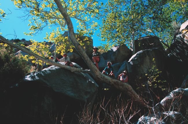
Sycamores and boulders, Sheep Canyon
Remote Sheep Canyon, secreted in the middle reaches of Coyote Canyon in Anza-Borrego Desert State Park, features some of the most rugged yet beautiful terrain in San Diego County. The canyon has two main forks (labeled Sheep Canyon and South Fork Sheep Canyon on maps), both containing trickling streams, full-skirted California fan palms, large sycamores, willowy cottonwoods, grottos with waterfalls, and boulder-sized rocks by the millions.
On account of the past season’s fairly abundant rainfall, the streams in both of Sheep Canyon’s forks should flow throughout the spring season. Since those rains came rather early, the wildflower bloom is a bit ahead of schedule. The canyon lies at a somewhat higher elevation than the desert floor, and that means the peak bloom might take place in late March.
The starting point for hikes into either fork of Sheep Canyon — Sheep Canyon Primitive Camp — is accessible these days only by the toughest kind of four-wheel-drive vehicle. Without that (and that means just about everyone) you face about three miles of final approach by horse, foot, or mountain bike. Overnight backpacking does the trick for many.
To get to Coyote Canyon and Sheep Canyon, drive north (hopefully not in a low-slung conventional automobile, but rather in a high-clearance, preferably four-wheel-drive truck or SUV) from the north end of the paved DiGiorgio Road in Borrego Springs onto the unpaved, sometimes rough road up along the east side of Coyote Canyon. After 5.6 miles on dirt and after three wet crossings of Coyote Creek, you reach a point below Lower Willows where the road turns sharply left (west) and later climbs a narrow, steep ravine. Parking space is fairly abundant for vehicles that have managed to get that far. The bypass road ahead, which swings left and climbs steeply, is sometimes referred to as “Boulder Alley.” It’s all but impassable now.
So, presumably on foot, you make your way up the steep, rocky road ahead to a summit, where the road levels and smooths out. The going is easy all the way to the Sheep Canyon campground. Once you get there, you can pitch a tent and explore either fork of Sheep Canyon at your leisure.
Although parts of the main Sheep Canyon are rugged and overgrown with lush vegetation, foot traffic in the lower end has hewn out a traceable, if primitive, footpath. From the campground it is only two miles — and an elevation gain of 900 feet — to a point where you enter a broad, bowl-shaped valley. This is a good place to enjoy the view of rugged peaks in every direction before turning around. Around the margins of the bowl, seasonal springs can be found in several of the small tributaries.
South Fork Sheep Canyon is, mile for mile, perhaps the most difficult canyon to explore in the whole of San Diego County. The rewards for exploring it in depth are a close-up view of an idyllic 30-foot waterfall, glimpses of a half-dozen more cascades, and the pleasure of exploring a hidden, upper valley seldom visited by humans.
Very ambitious hikers have forged connecting routes in between the upper reaches of Sheep Canyon and the South Fork. That kind of activity involves plenty of rock scrambling and bushwhacking through scratchy chaparral vegetation.
This article contains information about a publicly owned recreation or wilderness area. Trails and pathways are not necessarily marked. Conditions can change rapidly. Hikers should be properly equipped and have safety and navigational skills. The Reader and Jerry Schad assume no responsibility for any adverse experience.
Sheep Canyon
Anza-Borrego’s Sheep Canyon — hard-to-reach, but oh so beautiful.
Distance from downtown San Diego: 104 miles
Hiking length: Up to several, hard-fought miles
Difficulty: Strenuous to very strenuous
Here's something you might be interested in.
Sheep Canyon
Sheep Canyon
Sycamores and boulders, Sheep Canyon
Remote Sheep Canyon, secreted in the middle reaches of Coyote Canyon in Anza-Borrego Desert State Park, features some of the most rugged yet beautiful terrain in San Diego County. The canyon has two main forks (labeled Sheep Canyon and South Fork Sheep Canyon on maps), both containing trickling streams, full-skirted California fan palms, large sycamores, willowy cottonwoods, grottos with waterfalls, and boulder-sized rocks by the millions.
On account of the past season’s fairly abundant rainfall, the streams in both of Sheep Canyon’s forks should flow throughout the spring season. Since those rains came rather early, the wildflower bloom is a bit ahead of schedule. The canyon lies at a somewhat higher elevation than the desert floor, and that means the peak bloom might take place in late March.
The starting point for hikes into either fork of Sheep Canyon — Sheep Canyon Primitive Camp — is accessible these days only by the toughest kind of four-wheel-drive vehicle. Without that (and that means just about everyone) you face about three miles of final approach by horse, foot, or mountain bike. Overnight backpacking does the trick for many.
To get to Coyote Canyon and Sheep Canyon, drive north (hopefully not in a low-slung conventional automobile, but rather in a high-clearance, preferably four-wheel-drive truck or SUV) from the north end of the paved DiGiorgio Road in Borrego Springs onto the unpaved, sometimes rough road up along the east side of Coyote Canyon. After 5.6 miles on dirt and after three wet crossings of Coyote Creek, you reach a point below Lower Willows where the road turns sharply left (west) and later climbs a narrow, steep ravine. Parking space is fairly abundant for vehicles that have managed to get that far. The bypass road ahead, which swings left and climbs steeply, is sometimes referred to as “Boulder Alley.” It’s all but impassable now.
So, presumably on foot, you make your way up the steep, rocky road ahead to a summit, where the road levels and smooths out. The going is easy all the way to the Sheep Canyon campground. Once you get there, you can pitch a tent and explore either fork of Sheep Canyon at your leisure.
Although parts of the main Sheep Canyon are rugged and overgrown with lush vegetation, foot traffic in the lower end has hewn out a traceable, if primitive, footpath. From the campground it is only two miles — and an elevation gain of 900 feet — to a point where you enter a broad, bowl-shaped valley. This is a good place to enjoy the view of rugged peaks in every direction before turning around. Around the margins of the bowl, seasonal springs can be found in several of the small tributaries.
South Fork Sheep Canyon is, mile for mile, perhaps the most difficult canyon to explore in the whole of San Diego County. The rewards for exploring it in depth are a close-up view of an idyllic 30-foot waterfall, glimpses of a half-dozen more cascades, and the pleasure of exploring a hidden, upper valley seldom visited by humans.
Very ambitious hikers have forged connecting routes in between the upper reaches of Sheep Canyon and the South Fork. That kind of activity involves plenty of rock scrambling and bushwhacking through scratchy chaparral vegetation.
This article contains information about a publicly owned recreation or wilderness area. Trails and pathways are not necessarily marked. Conditions can change rapidly. Hikers should be properly equipped and have safety and navigational skills. The Reader and Jerry Schad assume no responsibility for any adverse experience.
Sheep Canyon
Anza-Borrego’s Sheep Canyon — hard-to-reach, but oh so beautiful.
Distance from downtown San Diego: 104 miles
Hiking length: Up to several, hard-fought miles
Difficulty: Strenuous to very strenuous