Here's something you might be interested in.
Ask a Hipster — Advice you didn't know you needed
Big Screen — Movie commentary
Blurt — Music's inside track
Booze News — San Diego spirits
Classical Music — Immortal beauty
Classifieds — Free and easy
Cover Stories — Front-page features
Drinks All Around — Bartenders' drink recipes
Excerpts — Literary and spiritual excerpts
Feast! — Food & drink reviews
Feature Stories — Local news & stories
Fishing Report — What’s getting hooked from ship and shore
From the Archives — Spotlight on the past
Golden Dreams — Talk of the town
The Gonzo Report — Making the musical scene, or at least reporting from it
Letters — Our inbox
Movies@Home — Local movie buffs share favorites
Movie Reviews — Our critics' picks and pans
Musician Interviews — Up close with local artists
Neighborhood News from Stringers — Hyperlocal news
News Ticker — News & politics
Obermeyer — San Diego politics illustrated
Outdoors — Weekly changes in flora and fauna
Overheard in San Diego — Eavesdropping illustrated
Poetry — The old and the new
Reader Travel — Travel section built by travelers
Reading — The hunt for intellectuals
Roam-O-Rama — SoCal's best hiking/biking trails
San Diego Beer — Inside San Diego suds
SD on the QT — Almost factual news
Sheep and Goats — Places of worship
Special Issues — The best of
Street Style — San Diego streets have style
Surf Diego — Real stories from those braving the waves
Theater — On stage in San Diego this week
Tin Fork — Silver spoon alternative
Under the Radar — Matt Potter's undercover work
Unforgettable — Long-ago San Diego
Unreal Estate — San Diego's priciest pads
Your Week — Daily event picks
Anza-Borrego's Pinyon Ridge
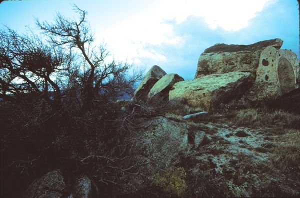
Pinyon Ridge, wild and foreboding on a blustery day
Like caterpillars marching to their own drummers, the rock-ribbed mountain ridges of the Anza-Borrego Desert nose this way and that, eventually finding their roots in the sand-drowned valleys sloping downward into the Salton Basin. The focus here is on the west-to-east-trending Pinyon Ridge, which stands just high enough on the desert rim to support a sparse growth of pinyon-pine trees.
You’ll follow a long-abandoned four-wheel-drive road along the crest of the ridge called the Wilson Trail. It now functions as a hiking-only footpath. The route, which extends just over four miles, leads to almost the exact center of a state wilderness area that is completely free of motorized travel. Prepare for total elevation gains and losses of 1400 feet over the 8.5 miles round trip. Bring warm clothes and some drinking water for early winter travel and plenty more water supplies when the temperatures start soaring in March or April.
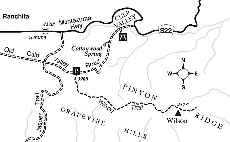
To reach the trailhead, first head toward Warner Springs, where you turn east on County Highway S2. After four miles, make a left on Montezuma Highway (S22), heading toward Ranchita and Borrego Springs. There are a couple of ways to arrive at the starting point, both of which may require a high-clearance vehicle, depending on road conditions. At mile 10.4 on Montezuma Highway — 10.4 miles east of Highway S2 and 5 miles east of Ranchita — turn right (west) on Old Culp Valley Road. Continue west for 1.1 miles to Cottonwood Spring, which may be the last place for standard passenger cars to turn around. Sturdy vehicles can continue another 1.9 miles to the intersection of the Wilson Trail, on the left. Limited parking is nearby. Alternatively, the trailhead can be reached from the outskirts of Ranchita by way of Jasper Trail and Old Culp Valley Road.
Starting from Old Culp Valley Road, the Wilson Trail’s eroded track meanders south and east over and around a series of rocky knolls on the crest of Pinyon Ridge. Common vegetation seen along the way includes chamise, sage brush, mountain mahogany, scrub oak, sugar bush, manzanita, Mojave yucca, buckhorn cholla cactus, juniper, and, of course, pinyon pine. Much of this vegetation is associated with the chaparral plant community, which makes its appearance in a narrow geographical belt following a contour of around 4000 feet elevation along the desert slope of many of Southern California’s coastal mountain ranges.
After traveling some four miles, you’ll pass north of “Wilson” peak (4573 feet). This is a good spot for a panoramic view. Scramble up over the rocks, discover a surveyor’s benchmark, and admire the view. Palomar Observatory’s dome gleams on the dark Palomar ridge to the west. The broad sweep of the Santa Rosa Mountains in the northeast serves as a backdrop for Borrego Valley and Coyote Mountain. Far to the east are the Salton Sea and the Chocolate Mountains of Imperial County. The Pinyon Mountains and Whale Peak rise to the southeast; and the Laguna and Cuyamaca mountains stand to the south and southwest.
If you’re into backpacking, this area makes a fine destination. In particular, look for a large, flat campsite 0.4 mile east-northeast of Wilson peak. If you walk a short distance north from there, you’ll get an exceptionally spacious view of Borrego Valley.
This article contains information about a publicly owned recreation or wilderness area. Trails and pathways are not necessarily marked. Conditions can change rapidly. Hikers should be properly equipped and have safety and navigational skills. The Reader and Jerry Schad assume no responsibility for any adverse experience.
Pinyon Ridge
Enjoy a cloud-scraping traverse along Anza-Borrego’s remote Pinyon Ridge.
Distance from downtown San Diego: 84 miles
Hiking length: 8+ miles round trip
Difficulty: Moderately strenuous
Here's something you might be interested in.
Anza-Borrego's Pinyon Ridge
Anza-Borrego's Pinyon Ridge
Pinyon Ridge, wild and foreboding on a blustery day
Like caterpillars marching to their own drummers, the rock-ribbed mountain ridges of the Anza-Borrego Desert nose this way and that, eventually finding their roots in the sand-drowned valleys sloping downward into the Salton Basin. The focus here is on the west-to-east-trending Pinyon Ridge, which stands just high enough on the desert rim to support a sparse growth of pinyon-pine trees.
You’ll follow a long-abandoned four-wheel-drive road along the crest of the ridge called the Wilson Trail. It now functions as a hiking-only footpath. The route, which extends just over four miles, leads to almost the exact center of a state wilderness area that is completely free of motorized travel. Prepare for total elevation gains and losses of 1400 feet over the 8.5 miles round trip. Bring warm clothes and some drinking water for early winter travel and plenty more water supplies when the temperatures start soaring in March or April.
To reach the trailhead, first head toward Warner Springs, where you turn east on County Highway S2. After four miles, make a left on Montezuma Highway (S22), heading toward Ranchita and Borrego Springs. There are a couple of ways to arrive at the starting point, both of which may require a high-clearance vehicle, depending on road conditions. At mile 10.4 on Montezuma Highway — 10.4 miles east of Highway S2 and 5 miles east of Ranchita — turn right (west) on Old Culp Valley Road. Continue west for 1.1 miles to Cottonwood Spring, which may be the last place for standard passenger cars to turn around. Sturdy vehicles can continue another 1.9 miles to the intersection of the Wilson Trail, on the left. Limited parking is nearby. Alternatively, the trailhead can be reached from the outskirts of Ranchita by way of Jasper Trail and Old Culp Valley Road.
Starting from Old Culp Valley Road, the Wilson Trail’s eroded track meanders south and east over and around a series of rocky knolls on the crest of Pinyon Ridge. Common vegetation seen along the way includes chamise, sage brush, mountain mahogany, scrub oak, sugar bush, manzanita, Mojave yucca, buckhorn cholla cactus, juniper, and, of course, pinyon pine. Much of this vegetation is associated with the chaparral plant community, which makes its appearance in a narrow geographical belt following a contour of around 4000 feet elevation along the desert slope of many of Southern California’s coastal mountain ranges.
After traveling some four miles, you’ll pass north of “Wilson” peak (4573 feet). This is a good spot for a panoramic view. Scramble up over the rocks, discover a surveyor’s benchmark, and admire the view. Palomar Observatory’s dome gleams on the dark Palomar ridge to the west. The broad sweep of the Santa Rosa Mountains in the northeast serves as a backdrop for Borrego Valley and Coyote Mountain. Far to the east are the Salton Sea and the Chocolate Mountains of Imperial County. The Pinyon Mountains and Whale Peak rise to the southeast; and the Laguna and Cuyamaca mountains stand to the south and southwest.
If you’re into backpacking, this area makes a fine destination. In particular, look for a large, flat campsite 0.4 mile east-northeast of Wilson peak. If you walk a short distance north from there, you’ll get an exceptionally spacious view of Borrego Valley.
This article contains information about a publicly owned recreation or wilderness area. Trails and pathways are not necessarily marked. Conditions can change rapidly. Hikers should be properly equipped and have safety and navigational skills. The Reader and Jerry Schad assume no responsibility for any adverse experience.
Pinyon Ridge
Enjoy a cloud-scraping traverse along Anza-Borrego’s remote Pinyon Ridge.
Distance from downtown San Diego: 84 miles
Hiking length: 8+ miles round trip
Difficulty: Moderately strenuous