Here's something you might be interested in.
Ask a Hipster — Advice you didn't know you needed
Big Screen — Movie commentary
Blurt — Music's inside track
Booze News — San Diego spirits
Classical Music — Immortal beauty
Classifieds — Free and easy
Cover Stories — Front-page features
Drinks All Around — Bartenders' drink recipes
Excerpts — Literary and spiritual excerpts
Feast! — Food & drink reviews
Feature Stories — Local news & stories
Fishing Report — What’s getting hooked from ship and shore
From the Archives — Spotlight on the past
Golden Dreams — Talk of the town
The Gonzo Report — Making the musical scene, or at least reporting from it
Letters — Our inbox
Movies@Home — Local movie buffs share favorites
Movie Reviews — Our critics' picks and pans
Musician Interviews — Up close with local artists
Neighborhood News from Stringers — Hyperlocal news
News Ticker — News & politics
Obermeyer — San Diego politics illustrated
Outdoors — Weekly changes in flora and fauna
Overheard in San Diego — Eavesdropping illustrated
Poetry — The old and the new
Reader Travel — Travel section built by travelers
Reading — The hunt for intellectuals
Roam-O-Rama — SoCal's best hiking/biking trails
San Diego Beer — Inside San Diego suds
SD on the QT — Almost factual news
Sheep and Goats — Places of worship
Special Issues — The best of
Street Style — San Diego streets have style
Surf Diego — Real stories from those braving the waves
Theater — On stage in San Diego this week
Tin Fork — Silver spoon alternative
Under the Radar — Matt Potter's undercover work
Unforgettable — Long-ago San Diego
Unreal Estate — San Diego's priciest pads
Your Week — Daily event picks
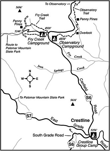
Fry Creek Trail
Fry Creek Campground, in the Cleveland National Forest on Palomar Mountain, offers the kind of forest camping experience that is becoming increasingly scarce in Southern California. A long-term drought cycle and various recent wildfires have taken their toll on the larger trees growing at higher elevations. Palomar, however, remains relatively lush with oaks and coniferous trees such as pine, firs, and cedars.
Any visit to Palomar should involve a walk in the woods, and Fry Creek Trail, which circles the campground, is one such possibility. Conveniently enough, it’s right on the way to the famed Palomar Observatory, which is open to the public during the daytime hours.
From Highway 76 at the foot of Palomar Mountain, take either South Grade Road or East Grade Road to where the two meet at a crossroads called Crestline, high atop the mountain. From there, follow Canfield Road north toward Palomar Observatory. After 2.7 miles, just beyond Observatory Campground, note the sign for Fry Creek Campground on the left. The campground is seasonal (summer only). For day-use purposes, you must park outside the campground gate, and even then you must post a National Forest Adventure Pass on your parked car. These passes — daily and yearly versions — are available at Crestline and at various outdoor-oriented businesses all over San Diego County.
The Fry Creek Trail has a history of intermittent maintenance, and it may be hard to follow in places. It starts at the entrance to Fry Creek Campground and winds somewhat circuitously upward around some ravines north of the camping area below. When you reach a dirt road, you’ll swing left toward a grove of planted “Penny Pines” atop a 5240-foot-elevation saddle. That’s where you’ll find a maintenance road coming up from Fry Creek Campground. You can use it to descend into the campground and return to the starting point. Or, you can try to find and follow a lesser-used section of the trail that loops back to the starting point along the slope south of the campsites. This slope, because of its north-facing aspect, features larger trees and more shade.
Yet another option presents itself at the 5240-foot saddle: From there, it’s possible to head down a ravine descending west, into Palomar Mountain State Park, using a sketchy path. This “non-official trail” features a few obstacles such as fallen trees and scratchy chaparral. Perhaps 20 minutes of descent takes you to the site of the Palomar School Camp. Nearby lies Doane Valley Campground and Doane Pond.
Take along drinking water, watch out for rattlesnakes, and keep kids close by on any ramble through this area.
This article contains information about a publicly owned recreation or wilderness area. Trails and pathways are not necessarily marked. Conditions can change rapidly. Hikers should be properly equipped and have safety and navigational skills. The Reader and Jerry Schad assume no responsibility for any adverse experience.
FRY CREEK TRAIL
Ramble through the forest outside Fry Creek Campground, near Palomar Observatory.
Distance from downtown San Diego: 60 miles
Hiking length: 1 mile or more
Difficulty: Easy to moderate
Here's something you might be interested in.
Fry Creek Trail
Fry Creek Trail
Fry Creek Campground, in the Cleveland National Forest on Palomar Mountain, offers the kind of forest camping experience that is becoming increasingly scarce in Southern California. A long-term drought cycle and various recent wildfires have taken their toll on the larger trees growing at higher elevations. Palomar, however, remains relatively lush with oaks and coniferous trees such as pine, firs, and cedars.
Any visit to Palomar should involve a walk in the woods, and Fry Creek Trail, which circles the campground, is one such possibility. Conveniently enough, it’s right on the way to the famed Palomar Observatory, which is open to the public during the daytime hours.
From Highway 76 at the foot of Palomar Mountain, take either South Grade Road or East Grade Road to where the two meet at a crossroads called Crestline, high atop the mountain. From there, follow Canfield Road north toward Palomar Observatory. After 2.7 miles, just beyond Observatory Campground, note the sign for Fry Creek Campground on the left. The campground is seasonal (summer only). For day-use purposes, you must park outside the campground gate, and even then you must post a National Forest Adventure Pass on your parked car. These passes — daily and yearly versions — are available at Crestline and at various outdoor-oriented businesses all over San Diego County.
The Fry Creek Trail has a history of intermittent maintenance, and it may be hard to follow in places. It starts at the entrance to Fry Creek Campground and winds somewhat circuitously upward around some ravines north of the camping area below. When you reach a dirt road, you’ll swing left toward a grove of planted “Penny Pines” atop a 5240-foot-elevation saddle. That’s where you’ll find a maintenance road coming up from Fry Creek Campground. You can use it to descend into the campground and return to the starting point. Or, you can try to find and follow a lesser-used section of the trail that loops back to the starting point along the slope south of the campsites. This slope, because of its north-facing aspect, features larger trees and more shade.
Yet another option presents itself at the 5240-foot saddle: From there, it’s possible to head down a ravine descending west, into Palomar Mountain State Park, using a sketchy path. This “non-official trail” features a few obstacles such as fallen trees and scratchy chaparral. Perhaps 20 minutes of descent takes you to the site of the Palomar School Camp. Nearby lies Doane Valley Campground and Doane Pond.
Take along drinking water, watch out for rattlesnakes, and keep kids close by on any ramble through this area.
This article contains information about a publicly owned recreation or wilderness area. Trails and pathways are not necessarily marked. Conditions can change rapidly. Hikers should be properly equipped and have safety and navigational skills. The Reader and Jerry Schad assume no responsibility for any adverse experience.
FRY CREEK TRAIL
Ramble through the forest outside Fry Creek Campground, near Palomar Observatory.
Distance from downtown San Diego: 60 miles
Hiking length: 1 mile or more
Difficulty: Easy to moderate