Here's something you might be interested in.
Ask a Hipster — Advice you didn't know you needed
Big Screen — Movie commentary
Blurt — Music's inside track
Booze News — San Diego spirits
Classical Music — Immortal beauty
Classifieds — Free and easy
Cover Stories — Front-page features
Drinks All Around — Bartenders' drink recipes
Excerpts — Literary and spiritual excerpts
Feast! — Food & drink reviews
Feature Stories — Local news & stories
Fishing Report — What’s getting hooked from ship and shore
From the Archives — Spotlight on the past
Golden Dreams — Talk of the town
The Gonzo Report — Making the musical scene, or at least reporting from it
Letters — Our inbox
Movies@Home — Local movie buffs share favorites
Movie Reviews — Our critics' picks and pans
Musician Interviews — Up close with local artists
Neighborhood News from Stringers — Hyperlocal news
News Ticker — News & politics
Obermeyer — San Diego politics illustrated
Outdoors — Weekly changes in flora and fauna
Overheard in San Diego — Eavesdropping illustrated
Poetry — The old and the new
Reader Travel — Travel section built by travelers
Reading — The hunt for intellectuals
Roam-O-Rama — SoCal's best hiking/biking trails
San Diego Beer — Inside San Diego suds
SD on the QT — Almost factual news
Sheep and Goats — Places of worship
Special Issues — The best of
Street Style — San Diego streets have style
Surf Diego — Real stories from those braving the waves
Theater — On stage in San Diego this week
Tin Fork — Silver spoon alternative
Under the Radar — Matt Potter's undercover work
Unforgettable — Long-ago San Diego
Unreal Estate — San Diego's priciest pads
Your Week — Daily event picks
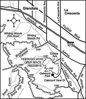
Oakmont Loop
The pint-sized (244-acre) Verdugo Mountains Open Space Preserve covers a scruffy patch of east-facing slopes in the city of Glendale. The circular hiking/biking route described here is pieced out of fire roads and residential streets bordering the property. The route is perfect for a late-afternoon outing, when you can benefit from staying in the shade, but at the same time enjoy a brightly lit valley and mountain vista to the east.
The hike is located in the Crescenta Valley area of greater Los Angeles. From La Crescenta Avenue, one mile south of Interstate 210, turn south on Oakmont View Drive. Follow this curvy residential street uphill to Oakmont View Park, where the street ends.
Starting from Oakmont View Park, follow the signed Edison Road (a fire road) and climb moderately on lazy twists and turns over the chaparral-clad slopes. The view east is somewhat compromised by some high-voltage powerlines in the near distance. Still, you can look across the sloping Crescenta Valley toward the dramatically rising San Gabriel Mountains, which culminate (from this perspective) at the antenna-bewhiskered summit of Mount Lukens. Those San Gabriel slopes have been looking lean and hungry of late, due to 2009’s catastrophic Station Fire. The suburban landscape closer at hand, which was mostly spared any damage during the fire, fills almost every reasonably flat patch of land from here to the base of the San Gabriels.
Before long, you’re starting a steep descent. At 1.0 mile you reach a gorgeous oak- and sycamore-filled glade in the bottom of a ravine called Engleheard Canyon (a perfect example of how civilization and wilderness can merge at the boundary of what is known as the wildland/urban interface). Just beyond, the Edison Road ends at a narrow driveway. Follow that driveway out to the suburbs at Eilinita Avenue, take a right on Emanuel Drive, and follow Emanuel to its end, 1.7 miles into the hike, where you again pick up Edison Road (a dirt road) on the left.
The remaining 0.8 mile of distance will take you some 500 feet higher to your starting point at Oakmont View Park. For mountain bikers, that final pitch requires a very low gear.
This article contains information about a publicly owned recreation or wilderness area. Trails and pathways are not necessarily marked. Conditions can change rapidly. Hikers should be properly equipped and have safety and navigational skills. The Reader and Jerry Schad assume no responsibility for any adverse experience.
OAKMONT LOOP
A short and steep, looping route on the outskirts of Glendale draws hikers and bikers.
Distance from downtown San Diego: 135 miles
Hiking/biking length: 2.5 miles
Difficulty: Moderate
Here's something you might be interested in.
Oakmont Loop
Oakmont Loop
The pint-sized (244-acre) Verdugo Mountains Open Space Preserve covers a scruffy patch of east-facing slopes in the city of Glendale. The circular hiking/biking route described here is pieced out of fire roads and residential streets bordering the property. The route is perfect for a late-afternoon outing, when you can benefit from staying in the shade, but at the same time enjoy a brightly lit valley and mountain vista to the east.
The hike is located in the Crescenta Valley area of greater Los Angeles. From La Crescenta Avenue, one mile south of Interstate 210, turn south on Oakmont View Drive. Follow this curvy residential street uphill to Oakmont View Park, where the street ends.
Starting from Oakmont View Park, follow the signed Edison Road (a fire road) and climb moderately on lazy twists and turns over the chaparral-clad slopes. The view east is somewhat compromised by some high-voltage powerlines in the near distance. Still, you can look across the sloping Crescenta Valley toward the dramatically rising San Gabriel Mountains, which culminate (from this perspective) at the antenna-bewhiskered summit of Mount Lukens. Those San Gabriel slopes have been looking lean and hungry of late, due to 2009’s catastrophic Station Fire. The suburban landscape closer at hand, which was mostly spared any damage during the fire, fills almost every reasonably flat patch of land from here to the base of the San Gabriels.
Before long, you’re starting a steep descent. At 1.0 mile you reach a gorgeous oak- and sycamore-filled glade in the bottom of a ravine called Engleheard Canyon (a perfect example of how civilization and wilderness can merge at the boundary of what is known as the wildland/urban interface). Just beyond, the Edison Road ends at a narrow driveway. Follow that driveway out to the suburbs at Eilinita Avenue, take a right on Emanuel Drive, and follow Emanuel to its end, 1.7 miles into the hike, where you again pick up Edison Road (a dirt road) on the left.
The remaining 0.8 mile of distance will take you some 500 feet higher to your starting point at Oakmont View Park. For mountain bikers, that final pitch requires a very low gear.
This article contains information about a publicly owned recreation or wilderness area. Trails and pathways are not necessarily marked. Conditions can change rapidly. Hikers should be properly equipped and have safety and navigational skills. The Reader and Jerry Schad assume no responsibility for any adverse experience.
OAKMONT LOOP
A short and steep, looping route on the outskirts of Glendale draws hikers and bikers.
Distance from downtown San Diego: 135 miles
Hiking/biking length: 2.5 miles
Difficulty: Moderate