Here's something you might be interested in.
Ask a Hipster — Advice you didn't know you needed
Big Screen — Movie commentary
Blurt — Music's inside track
Booze News — San Diego spirits
Classical Music — Immortal beauty
Classifieds — Free and easy
Cover Stories — Front-page features
Drinks All Around — Bartenders' drink recipes
Excerpts — Literary and spiritual excerpts
Feast! — Food & drink reviews
Feature Stories — Local news & stories
Fishing Report — What’s getting hooked from ship and shore
From the Archives — Spotlight on the past
Golden Dreams — Talk of the town
The Gonzo Report — Making the musical scene, or at least reporting from it
Letters — Our inbox
Movies@Home — Local movie buffs share favorites
Movie Reviews — Our critics' picks and pans
Musician Interviews — Up close with local artists
Neighborhood News from Stringers — Hyperlocal news
News Ticker — News & politics
Obermeyer — San Diego politics illustrated
Outdoors — Weekly changes in flora and fauna
Overheard in San Diego — Eavesdropping illustrated
Poetry — The old and the new
Reader Travel — Travel section built by travelers
Reading — The hunt for intellectuals
Roam-O-Rama — SoCal's best hiking/biking trails
San Diego Beer — Inside San Diego suds
SD on the QT — Almost factual news
Sheep and Goats — Places of worship
Special Issues — The best of
Street Style — San Diego streets have style
Surf Diego — Real stories from those braving the waves
Theater — On stage in San Diego this week
Tin Fork — Silver spoon alternative
Under the Radar — Matt Potter's undercover work
Unforgettable — Long-ago San Diego
Unreal Estate — San Diego's priciest pads
Your Week — Daily event picks
Blue Angels Peak
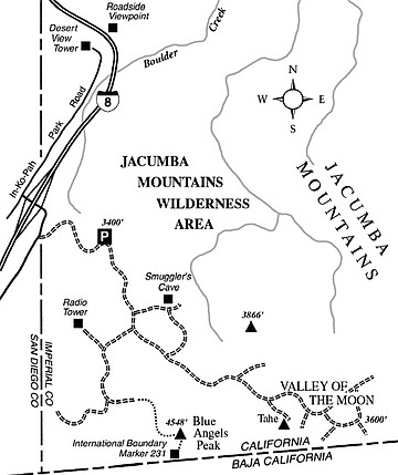
Blue Angels Peak is the name of a prominent crag practically sitting on the border between California and Baja California, just east of the high-desert community of Jacumba. In fact, the summit of Blue Angels Peak just happens to be the point of highest elevation in California within six miles of the international border.
Blue Angels lies within a rugged set of peaks and valleys in the Jacumba Mountains — an area adminstered by the federal Bureau of Land Management and designated as the Jacumba Mountains Wilderness Area. South of the border these same mountains stretch about 100 miles into Mexico, where they are known as the Sierra Juarez. On both sides of the border you can see great stacks of weathered boulders, with scattered junipers and pinyon pines growing in pockets of sand or soil.
To get to the starting point from San Diego, drive east on Interstate 8 about 70 miles and exit at In-Ko-Pah Park Road (just east of Jacumba). Turn right and drive southwest 0.2 mile along the frontage road, Old Highway 80. Turn left onto the dirt road heading into the dry hills. Proceed 0.8 mile up this road and park at a large turnout. This is the assumed starting point for hiking, but use discretion about how far you can safely drive up this road. That would depend on the condition of the road and on the toughness of your vehicle. Your hike will measure five miles round-trip if you start walking from the turnout.
On foot, head up the road to a saddle at 3830 feet. An old dirt road branches left and leads to Smuggler’s Cave, an historic hideout of bandits and smugglers, now a fire-blackened, graffiti-emblazoned wreck. Proceed another 0.1 mile south and bear right (west). Continue south and finally east to the road’s end, staying left at two junctions at 1.1 and 1.4 miles. An old mining prospect lies at the end.
Blue Angels Peak is to the southeast, hidden behind a false peak capped by a massive block of granite seemingly poised to roll. Scramble up over lichen-encrusted boulders and past scraggly pinyons to find a U.S. Geological Survey benchmark on the summit.
On the return trip, you can make a short detour to discover International Boundary Marker 231, a handsome 10-foot steel obelisk, in the middle of a flat south and a little west of the peak. These markers are numbered consecutively along the border from #1 at the Gulf of Mexico shoreline east of Brownsville-Matamoros (Texas) to #258 at the Pacific shoreline near Imperial Beach.
U.S. Border Patrol agents intensively monitor the entire border area. You will almost certainly interact with at least one of them while visiting here. Consider bringing along a passport or other appropriate documentation to prove that you are a U.S. citizen or have a valid reason to be in the U.S. Also, keep in mind that it is safer to travel in groups while visiting the border region.
This article contains information about a publicly owned recreation or wilderness area. Trails and pathways are not necessarily marked. Conditions can change rapidly. Hikers should be properly equipped and have safety and navigational skills. The Reader and Jerry Schad assume no responsibility for any adverse experience.
Blue Angels Peak
Climb the wind-blown summit of Blue Angels Peak near Jacumba and behold a binational panorama.
Distance from downtown San Diego: 70 miles
Hiking length: 5.0 miles round-trip
Difficulty: Moderately strenuous
Here's something you might be interested in.
Blue Angels Peak
Blue Angels Peak
Blue Angels Peak is the name of a prominent crag practically sitting on the border between California and Baja California, just east of the high-desert community of Jacumba. In fact, the summit of Blue Angels Peak just happens to be the point of highest elevation in California within six miles of the international border.
Blue Angels lies within a rugged set of peaks and valleys in the Jacumba Mountains — an area adminstered by the federal Bureau of Land Management and designated as the Jacumba Mountains Wilderness Area. South of the border these same mountains stretch about 100 miles into Mexico, where they are known as the Sierra Juarez. On both sides of the border you can see great stacks of weathered boulders, with scattered junipers and pinyon pines growing in pockets of sand or soil.
To get to the starting point from San Diego, drive east on Interstate 8 about 70 miles and exit at In-Ko-Pah Park Road (just east of Jacumba). Turn right and drive southwest 0.2 mile along the frontage road, Old Highway 80. Turn left onto the dirt road heading into the dry hills. Proceed 0.8 mile up this road and park at a large turnout. This is the assumed starting point for hiking, but use discretion about how far you can safely drive up this road. That would depend on the condition of the road and on the toughness of your vehicle. Your hike will measure five miles round-trip if you start walking from the turnout.
On foot, head up the road to a saddle at 3830 feet. An old dirt road branches left and leads to Smuggler’s Cave, an historic hideout of bandits and smugglers, now a fire-blackened, graffiti-emblazoned wreck. Proceed another 0.1 mile south and bear right (west). Continue south and finally east to the road’s end, staying left at two junctions at 1.1 and 1.4 miles. An old mining prospect lies at the end.
Blue Angels Peak is to the southeast, hidden behind a false peak capped by a massive block of granite seemingly poised to roll. Scramble up over lichen-encrusted boulders and past scraggly pinyons to find a U.S. Geological Survey benchmark on the summit.
On the return trip, you can make a short detour to discover International Boundary Marker 231, a handsome 10-foot steel obelisk, in the middle of a flat south and a little west of the peak. These markers are numbered consecutively along the border from #1 at the Gulf of Mexico shoreline east of Brownsville-Matamoros (Texas) to #258 at the Pacific shoreline near Imperial Beach.
U.S. Border Patrol agents intensively monitor the entire border area. You will almost certainly interact with at least one of them while visiting here. Consider bringing along a passport or other appropriate documentation to prove that you are a U.S. citizen or have a valid reason to be in the U.S. Also, keep in mind that it is safer to travel in groups while visiting the border region.
This article contains information about a publicly owned recreation or wilderness area. Trails and pathways are not necessarily marked. Conditions can change rapidly. Hikers should be properly equipped and have safety and navigational skills. The Reader and Jerry Schad assume no responsibility for any adverse experience.
Blue Angels Peak
Climb the wind-blown summit of Blue Angels Peak near Jacumba and behold a binational panorama.
Distance from downtown San Diego: 70 miles
Hiking length: 5.0 miles round-trip
Difficulty: Moderately strenuous