Here's something you might be interested in.
Ask a Hipster — Advice you didn't know you needed
Big Screen — Movie commentary
Blurt — Music's inside track
Booze News — San Diego spirits
Classical Music — Immortal beauty
Classifieds — Free and easy
Cover Stories — Front-page features
Drinks All Around — Bartenders' drink recipes
Excerpts — Literary and spiritual excerpts
Feast! — Food & drink reviews
Feature Stories — Local news & stories
Fishing Report — What’s getting hooked from ship and shore
From the Archives — Spotlight on the past
Golden Dreams — Talk of the town
The Gonzo Report — Making the musical scene, or at least reporting from it
Letters — Our inbox
Movies@Home — Local movie buffs share favorites
Movie Reviews — Our critics' picks and pans
Musician Interviews — Up close with local artists
Neighborhood News from Stringers — Hyperlocal news
News Ticker — News & politics
Obermeyer — San Diego politics illustrated
Outdoors — Weekly changes in flora and fauna
Overheard in San Diego — Eavesdropping illustrated
Poetry — The old and the new
Reader Travel — Travel section built by travelers
Reading — The hunt for intellectuals
Roam-O-Rama — SoCal's best hiking/biking trails
San Diego Beer — Inside San Diego suds
SD on the QT — Almost factual news
Sheep and Goats — Places of worship
Special Issues — The best of
Street Style — San Diego streets have style
Surf Diego — Real stories from those braving the waves
Theater — On stage in San Diego this week
Tin Fork — Silver spoon alternative
Under the Radar — Matt Potter's undercover work
Unforgettable — Long-ago San Diego
Unreal Estate — San Diego's priciest pads
Your Week — Daily event picks
Climb to the top of Bucksnort Mountain, a high, but little-known mini-mountain-range in northeast San Diego County.
The northernmost stretch of the Pacific Crest Trail (PCT) in San Diego County traverses the flank of the colorfully named Bucksnort Mountain. Combs Peak is the highest summit on that mountain ridge, and rates as one of the highest elevations within the county. To reach the top you must be prepared for some off-trail, cross-country hiking.
The getting-there-by-car phase is a mini-adventure in itself. From Highway 79, 11 miles north of Warner Springs, turn east on Chihuahua Valley Road. Go 6.3 miles east to a sharp right bend in the paved road. Straight ahead at that juncture is unpaved Lost Valley Road (bumpy but normally suitable for ordinary cars), leading 10 miles to the Lost Valley Boy Scout Camp. Drive for about 5 miles on this road and look for the place where the PCT crosses the road. There's space to park on the left, and a sign indicating distances northward along the Pacific Crest Trail.
From your parking spot, follow the PCT as it wends its lazy way gradually uphill through scattered chaparral, most of which has been singed in recent wildfires. Some fire-following wildflowers, such as lupine, may be in bloom depending on the amount of recent rainfall. Rocks strewn about the trail sparkle with sunlight reflected from the large mica crystals within them. The ridgeline of Bucksnort Mountain on the left is bewhiskered with the blackened trunks of thoroughly incinerated Coulter pines. This stark scene is mirrored by the spacious and completely empty (as it appears from here, anyway) terrain of the Anza-Borrego Desert on the right and below.
After 2.7 miles of walking on the PCT, you'll come to a crest on the east shoulder of Combs Peak. From this point, leave the PCT and simply go uphill through the chaparral vegetation in the most direct manner possible, following a rough route worn in by hikers. The way is marked somewhat obscurely by "ducks" -- small piles of stones placed as trail markers by hikers.
After considerable huffing, puffing, and foot sliding, you stand upon Combs Peak, which overlooks many mountain ranges and valleys in the northern San Diego County/southern Riverside County region. Most impressive, perhaps, is the great wall of the Santa Rosa Mountains just east, culminating at 8716-foot Toro Peak. Lost in the reverie of the view, you may be startled by the sudden "whoosh" of a sailplane sneaking up behind you and barely clearing the peak.
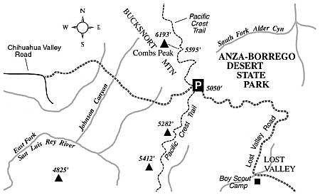
The quickest way to get back is by the same route. Take care when negotiating the sometimes-slippery slope that takes you back down to the PCT.
This article contains information about a publicly owned recreation or wilderness area. Trails and pathways are not necessarily marked. Conditions can change rapidly. Hikers should be properly equipped and have safety and navigational skills. The Reader and Jerry Schad assume no responsibility for any adverse experience.
Here's something you might be interested in.
Climb to the top of Bucksnort Mountain, a high, but little-known mini-mountain-range in northeast San Diego County.
Climb to the top of Bucksnort Mountain, a high, but little-known mini-mountain-range in northeast San Diego County.
The northernmost stretch of the Pacific Crest Trail (PCT) in San Diego County traverses the flank of the colorfully named Bucksnort Mountain. Combs Peak is the highest summit on that mountain ridge, and rates as one of the highest elevations within the county. To reach the top you must be prepared for some off-trail, cross-country hiking.
The getting-there-by-car phase is a mini-adventure in itself. From Highway 79, 11 miles north of Warner Springs, turn east on Chihuahua Valley Road. Go 6.3 miles east to a sharp right bend in the paved road. Straight ahead at that juncture is unpaved Lost Valley Road (bumpy but normally suitable for ordinary cars), leading 10 miles to the Lost Valley Boy Scout Camp. Drive for about 5 miles on this road and look for the place where the PCT crosses the road. There's space to park on the left, and a sign indicating distances northward along the Pacific Crest Trail.
From your parking spot, follow the PCT as it wends its lazy way gradually uphill through scattered chaparral, most of which has been singed in recent wildfires. Some fire-following wildflowers, such as lupine, may be in bloom depending on the amount of recent rainfall. Rocks strewn about the trail sparkle with sunlight reflected from the large mica crystals within them. The ridgeline of Bucksnort Mountain on the left is bewhiskered with the blackened trunks of thoroughly incinerated Coulter pines. This stark scene is mirrored by the spacious and completely empty (as it appears from here, anyway) terrain of the Anza-Borrego Desert on the right and below.
After 2.7 miles of walking on the PCT, you'll come to a crest on the east shoulder of Combs Peak. From this point, leave the PCT and simply go uphill through the chaparral vegetation in the most direct manner possible, following a rough route worn in by hikers. The way is marked somewhat obscurely by "ducks" -- small piles of stones placed as trail markers by hikers.
After considerable huffing, puffing, and foot sliding, you stand upon Combs Peak, which overlooks many mountain ranges and valleys in the northern San Diego County/southern Riverside County region. Most impressive, perhaps, is the great wall of the Santa Rosa Mountains just east, culminating at 8716-foot Toro Peak. Lost in the reverie of the view, you may be startled by the sudden "whoosh" of a sailplane sneaking up behind you and barely clearing the peak.
The quickest way to get back is by the same route. Take care when negotiating the sometimes-slippery slope that takes you back down to the PCT.
This article contains information about a publicly owned recreation or wilderness area. Trails and pathways are not necessarily marked. Conditions can change rapidly. Hikers should be properly equipped and have safety and navigational skills. The Reader and Jerry Schad assume no responsibility for any adverse experience.
Comments