Here's something you might be interested in.
Ask a Hipster — Advice you didn't know you needed
Big Screen — Movie commentary
Blurt — Music's inside track
Booze News — San Diego spirits
Classical Music — Immortal beauty
Classifieds — Free and easy
Close to Home — What it’s like on the street where you live
Cover Stories — Front-page features
Drinks All Around — Bartenders' drink recipes
Excerpts — Literary and spiritual excerpts
Feast! — Food & drink reviews
Feature Stories — Local news & stories
Fishing Report — What’s getting hooked from ship and shore
From the Archives — Spotlight on the past
Golden Dreams — Talk of the town
The Gonzo Report — Making the musical scene, or at least reporting from it
Letters — Our inbox
Movies@Home — Local movie buffs share favorites
Movie Reviews — Our critics' picks and pans
Musician Interviews — Up close with local artists
Neighborhood News from Stringers — Hyperlocal news
News Ticker — News & politics
Obermeyer — San Diego politics illustrated
Outdoors — Weekly changes in flora and fauna
Overheard in San Diego — Eavesdropping illustrated
Poetry — The old and the new
Reader Travel — Travel section built by travelers
Reading — The hunt for intellectuals
Roam-O-Rama — SoCal's best hiking/biking trails
San Diego Beer — Inside San Diego suds
SD on the QT — Almost factual news
Sheep and Goats — Places of worship
Special Issues — The best of
Street Style — San Diego streets have style
Surf Diego — Real stories from those braving the waves
Theater — On stage in San Diego this week
Tin Fork — Silver spoon alternative
Under the Radar — Matt Potter's undercover work
Unforgettable — Long-ago San Diego
Unreal Estate — San Diego's priciest pads
Your Week — Daily event picks
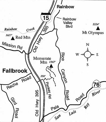
Climb to a 1567-foot summit east of Fallbrook and enjoy an ocean-to-mountain panorama.
The dark west flank of Monserate Mountain rises abruptly alongside Interstate 15, its chaparral-coated surface relatively uncut by roads and graded residential lots. The Fallbrook Land Conservancy has established its largest preserve here, the 340-acre Monserate Mountain Preserve. The hike to the 1567-foot high point on the mountain could be considered a chore, but optimistically (it's easy to be optimistic if you hike on a clear, cool day) the experience combines some heart-pounding exercise with a spacious and panoramic view at the top.
To get to the starting point for the hike, exit Interstate 15 at Highway 76 (Pala Road). Turn west and proceed a short distance to Old Highway 395 (the west-side frontage road of I-15). Turn right and continue 2.6 miles north on Old Highway 395 to Stewart Canyon Road, on the right. Drive under I-15 on this road and on the other side you will meet Pankey Road, which offers abundant space for parking. The Monserate Mountain trailhead, marked with a small signpost, is immediately to the right (south) of the intersection.
From the trailhead, the rough and sometimes severely eroded trail wastes little distance -- except for a couple of zigzags -- in ascending the mountain's steep west slope. The white noise of traffic on the freeway fades as you climb, perhaps becoming no louder than your own heavy breathing. At 0.8 mile and 650 feet higher you reach a disused, one-lane paved road. Turn left and swing north on the deteriorating remnants of this road. After another 0.1 mile, pavement ends; just veer right on the dirt trail ahead. Lettered signposts clearly lead the way north and then east. Ignore two side paths on the left, and climb around a switchback to a saddle just below the Monserate Mountain summit. There, a ridge-running trail contours south toward a large water tank on the ridge, while the trail to the summit heads upward and east for about 100 yards to the high point, which is about 1200 feet above where you started your hike.
On the summit itself, an eastern view is revealed for the first time: Agua Tibia Mountain (an arm of the Palomar Mountains) rises boldly from lesser hills and valleys -- the latter often draped in a vaporous haze. To the north spreads the typical Fallbrook mosaic of scattered houses and avocado-draped hillsides. In the west a couple of miles away, the reflective surface of a reservoir atop a ridge mirrors the color of the sky behind it (an aqueduct serving San Diego County passes nearby, so the reality of a ridgetop lake is not so peculiar). Visible beyond the lake on clearer days is the arc of the ocean, blue here or silvery there, depending on the sun angle.
This article contains information about a publicly owned recreation or wilderness area. Trails and pathways are not necessarily marked. Conditions can change rapidly. Hikers should be properly equipped and have safety and navigational skills. The Reader and Jerry Schad assume no responsibility for any adverse experience.
Here's something you might be interested in.
Climb to a 1567-foot summit east of Fallbrook and enjoy an ocean-to-mountain panorama.
Climb to a 1567-foot summit east of Fallbrook and enjoy an ocean-to-mountain panorama.
The dark west flank of Monserate Mountain rises abruptly alongside Interstate 15, its chaparral-coated surface relatively uncut by roads and graded residential lots. The Fallbrook Land Conservancy has established its largest preserve here, the 340-acre Monserate Mountain Preserve. The hike to the 1567-foot high point on the mountain could be considered a chore, but optimistically (it's easy to be optimistic if you hike on a clear, cool day) the experience combines some heart-pounding exercise with a spacious and panoramic view at the top.
To get to the starting point for the hike, exit Interstate 15 at Highway 76 (Pala Road). Turn west and proceed a short distance to Old Highway 395 (the west-side frontage road of I-15). Turn right and continue 2.6 miles north on Old Highway 395 to Stewart Canyon Road, on the right. Drive under I-15 on this road and on the other side you will meet Pankey Road, which offers abundant space for parking. The Monserate Mountain trailhead, marked with a small signpost, is immediately to the right (south) of the intersection.
From the trailhead, the rough and sometimes severely eroded trail wastes little distance -- except for a couple of zigzags -- in ascending the mountain's steep west slope. The white noise of traffic on the freeway fades as you climb, perhaps becoming no louder than your own heavy breathing. At 0.8 mile and 650 feet higher you reach a disused, one-lane paved road. Turn left and swing north on the deteriorating remnants of this road. After another 0.1 mile, pavement ends; just veer right on the dirt trail ahead. Lettered signposts clearly lead the way north and then east. Ignore two side paths on the left, and climb around a switchback to a saddle just below the Monserate Mountain summit. There, a ridge-running trail contours south toward a large water tank on the ridge, while the trail to the summit heads upward and east for about 100 yards to the high point, which is about 1200 feet above where you started your hike.
On the summit itself, an eastern view is revealed for the first time: Agua Tibia Mountain (an arm of the Palomar Mountains) rises boldly from lesser hills and valleys -- the latter often draped in a vaporous haze. To the north spreads the typical Fallbrook mosaic of scattered houses and avocado-draped hillsides. In the west a couple of miles away, the reflective surface of a reservoir atop a ridge mirrors the color of the sky behind it (an aqueduct serving San Diego County passes nearby, so the reality of a ridgetop lake is not so peculiar). Visible beyond the lake on clearer days is the arc of the ocean, blue here or silvery there, depending on the sun angle.
This article contains information about a publicly owned recreation or wilderness area. Trails and pathways are not necessarily marked. Conditions can change rapidly. Hikers should be properly equipped and have safety and navigational skills. The Reader and Jerry Schad assume no responsibility for any adverse experience.