Here's something you might be interested in.
Ask a Hipster — Advice you didn't know you needed
Big Screen — Movie commentary
Blurt — Music's inside track
Booze News — San Diego spirits
Classical Music — Immortal beauty
Classifieds — Free and easy
Close to Home — What it’s like on the street where you live
Cover Stories — Front-page features
Drinks All Around — Bartenders' drink recipes
Excerpts — Literary and spiritual excerpts
Feast! — Food & drink reviews
Feature Stories — Local news & stories
Fishing Report — What’s getting hooked from ship and shore
From the Archives — Spotlight on the past
Golden Dreams — Talk of the town
The Gonzo Report — Making the musical scene, or at least reporting from it
Letters — Our inbox
Movies@Home — Local movie buffs share favorites
Movie Reviews — Our critics' picks and pans
Musician Interviews — Up close with local artists
Neighborhood News from Stringers — Hyperlocal news
News Ticker — News & politics
Obermeyer — San Diego politics illustrated
Outdoors — Weekly changes in flora and fauna
Overheard in San Diego — Eavesdropping illustrated
Poetry — The old and the new
Reader Travel — Travel section built by travelers
Reading — The hunt for intellectuals
Roam-O-Rama — SoCal's best hiking/biking trails
San Diego Beer — Inside San Diego suds
SD on the QT — Almost factual news
Sheep and Goats — Places of worship
Special Issues — The best of
Street Style — San Diego streets have style
Surf Diego — Real stories from those braving the waves
Theater — On stage in San Diego this week
Tin Fork — Silver spoon alternative
Under the Radar — Matt Potter's undercover work
Unforgettable — Long-ago San Diego
Unreal Estate — San Diego's priciest pads
Your Week — Daily event picks
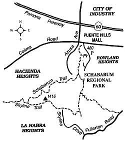
Rise above the mists of the San Gabriel Valley on the Schabarum Trail.
Schabarum Regional Park in Rowland Heights (eastern Los Angeles County) features a green-grass strip extending nearly a mile into the Puente Hills and lots of steep, brushy hillsides affording some great panoramas of the San Gabriel Valley and the San Gabriel Mountains. You'll probably share these views with hawks and ravens who ride the hillside thermals if you follow the five-mile looping hike outlined here. This is a great trip for Santa Ana days, when the dry, northeast winds sweep away the haze and smog that often blankets the L.A. Basin.
To get to Schabarum Park, exit the Pomona Freeway (Highway 60) at Azusa Avenue, go south alongside the Puente Hills Mall, turn left on Colima Road, then turn immediately right into Schabarum Park. Gates are open daily from 8 a.m. to sunset. Park your car in any of the spacious lots (a parking fee is charged on weekends and holidays only), and start your hike on the signed Schabarum Trail. It begins near the entrance and twists and turns along dry, prickly-pear-covered slopes west of the park's long strip of green turf. At 0.8 mile you come to a split; the left branch goes over to an equestrian ring at the south end of the turf strip, while the right branch, your route, takes you up through dense chaparral toward the Puente Hills crest. The panorama below includes nearby subdivisions in Hacienda Heights, the linear City of Industry (which, it is manifestly clear, specializes in industry), and assorted other suburban sprawl stretching to the foot of the San Gabriel Mountains. The beige (or white, if snow-capped) summit of Mount San Antonio, or Old Baldy, floats serenely above it all.
As you approach the ridgeline, you contour below an antenna-topped 1416-foot peak. A shortcut to the Skyline Trail is possible up and around this.
After 2.5 miles from the park entrance, bear left as you're approaching a water tower and antenna site served by a paved service road coming up from below. Follow the dirt road going east, which is the Skyline Trail. You climb some more, passing the 1416-foot peak, and then descend. To the south you look over the wooded community of La Habra Heights and across the coastal plains of Orange County.
After winding down a steep hillside, you reach a north-south dirt road in a saddle (3.8 miles). Go left and continue 0.7 mile down a draw to the equestrian ring. From there you can follow an asphalt walkway down the middle of the turf area to reach your parked car.
Here's something you might be interested in.
Rise above the mists of the San Gabriel Valley on the Schabarum Trail.
Rise above the mists of the San Gabriel Valley on the Schabarum Trail.
Schabarum Regional Park in Rowland Heights (eastern Los Angeles County) features a green-grass strip extending nearly a mile into the Puente Hills and lots of steep, brushy hillsides affording some great panoramas of the San Gabriel Valley and the San Gabriel Mountains. You'll probably share these views with hawks and ravens who ride the hillside thermals if you follow the five-mile looping hike outlined here. This is a great trip for Santa Ana days, when the dry, northeast winds sweep away the haze and smog that often blankets the L.A. Basin.
To get to Schabarum Park, exit the Pomona Freeway (Highway 60) at Azusa Avenue, go south alongside the Puente Hills Mall, turn left on Colima Road, then turn immediately right into Schabarum Park. Gates are open daily from 8 a.m. to sunset. Park your car in any of the spacious lots (a parking fee is charged on weekends and holidays only), and start your hike on the signed Schabarum Trail. It begins near the entrance and twists and turns along dry, prickly-pear-covered slopes west of the park's long strip of green turf. At 0.8 mile you come to a split; the left branch goes over to an equestrian ring at the south end of the turf strip, while the right branch, your route, takes you up through dense chaparral toward the Puente Hills crest. The panorama below includes nearby subdivisions in Hacienda Heights, the linear City of Industry (which, it is manifestly clear, specializes in industry), and assorted other suburban sprawl stretching to the foot of the San Gabriel Mountains. The beige (or white, if snow-capped) summit of Mount San Antonio, or Old Baldy, floats serenely above it all.
As you approach the ridgeline, you contour below an antenna-topped 1416-foot peak. A shortcut to the Skyline Trail is possible up and around this.
After 2.5 miles from the park entrance, bear left as you're approaching a water tower and antenna site served by a paved service road coming up from below. Follow the dirt road going east, which is the Skyline Trail. You climb some more, passing the 1416-foot peak, and then descend. To the south you look over the wooded community of La Habra Heights and across the coastal plains of Orange County.
After winding down a steep hillside, you reach a north-south dirt road in a saddle (3.8 miles). Go left and continue 0.7 mile down a draw to the equestrian ring. From there you can follow an asphalt walkway down the middle of the turf area to reach your parked car.