Here's something you might be interested in.
Ask a Hipster — Advice you didn't know you needed
Big Screen — Movie commentary
Blurt — Music's inside track
Booze News — San Diego spirits
Classical Music — Immortal beauty
Classifieds — Free and easy
Cover Stories — Front-page features
Drinks All Around — Bartenders' drink recipes
Excerpts — Literary and spiritual excerpts
Feast! — Food & drink reviews
Feature Stories — Local news & stories
Fishing Report — What’s getting hooked from ship and shore
From the Archives — Spotlight on the past
Golden Dreams — Talk of the town
The Gonzo Report — Making the musical scene, or at least reporting from it
Letters — Our inbox
Movies@Home — Local movie buffs share favorites
Movie Reviews — Our critics' picks and pans
Musician Interviews — Up close with local artists
Neighborhood News from Stringers — Hyperlocal news
News Ticker — News & politics
Obermeyer — San Diego politics illustrated
Outdoors — Weekly changes in flora and fauna
Overheard in San Diego — Eavesdropping illustrated
Poetry — The old and the new
Reader Travel — Travel section built by travelers
Reading — The hunt for intellectuals
Roam-O-Rama — SoCal's best hiking/biking trails
San Diego Beer — Inside San Diego suds
SD on the QT — Almost factual news
Sheep and Goats — Places of worship
Special Issues — The best of
Street Style — San Diego streets have style
Surf Diego — Real stories from those braving the waves
Theater — On stage in San Diego this week
Tin Fork — Silver spoon alternative
Under the Radar — Matt Potter's undercover work
Unforgettable — Long-ago San Diego
Unreal Estate — San Diego's priciest pads
Your Week — Daily event picks
It Would Turn You To Toast
How they fought 2004 Campo fire
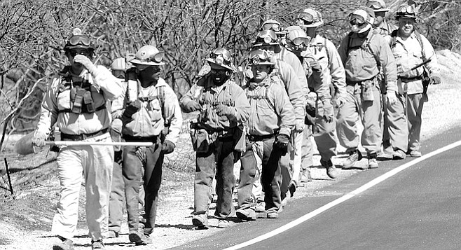
CDF hand crew along Highway 94. "The wind was blowing burning brands and embers down the hill and across Highway 94, where firefighters were trying to make another stand."
Pete Scully, a battalion chief for the California Department of Forestry's fire protection agency, stands next to his camper-shelled pickup truck at a Highway 94 turnoff east of where Campo Creek turns south into Mexico, about halfway between Campo and Potrero. The hill looming on the south side of the road is completely blackened, the aftermath of a wildfire that roared through this area the day before, Monday, September 13. The dried leaves on the cottonwoods in the creek bed rustle in the afternoon wind. Each gentle puff of breeze carries the smell of soot and ash. All around, thin wisps of smoke rise from bushes still smoldering. Scully is a suntanned man in the neighborhood of 50. About six feet tall, he's wearing a yellow jumpsuit speckled with the red of fire retardant dropped from aircraft yesterday. On his head he wears a blue cap with CDF embroidered in gold letters. The sun reflects off his wraparound sunglasses as he recounts yesterday's fire, which was first reported around 10:00 a.m. "We could see the smoke, and we could see it was in Mexico. So I held off on the [large-scale] dispatch."
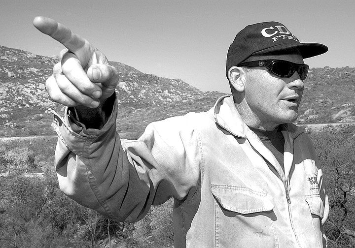
Pete Scully: "We can't work under the power lines because they can arc to the ground through the smoke. That happened four times yesterday. The smoke has enough moisture content with the soot and oils and such that it conducts 500,000 volts to the ground."
Instead, Scully rolled one truck out of Potrero, five miles west. "We went out to take a look and find out what the axis was going to be and whether we needed to take action. So we got in and saw that it was going to impact us. See this canyon back over here?" He points southwest to where Campo Creek, paralleled by the San Diego and Arizona Eastern railroad tracks, heads into Mexico. "If you follow that canyon down you can see where the fire started down in Mexico just at the bottom of that canyon."
Jed Burt: "We finally found a spot where we could set down that wasn't in the path of the fire, and they set it down, dropped the crew off, and went straight to the water draft" -- a pond in Cameron Corners -- "to try to keep it from jumping the border."
Asked what started the blaze, he answers, "It could have been a migrant campfire because there is a lot of illegal alien traffic that comes through there. There are also some ranches down in there. It could have been something dumped from the ranch that accidentally started a fire. It's really hard to say, and we have no right to go into Mexico to investigate.
"Anyway," he continues, "the fire was burning well, but not running very rapidly. It started burning its way a little bit east and north up the ridge, just as we'd expect it to do. Again, it was fairly mellow burning conditions, like today."
Today it's a touch over 80 degrees with moderate humidity and a light, cool breeze blowing out of the west. When he realized the fire would cross the border, Scully "ordered 15 engines, four hand crews, and two bulldozers" from the nearby rural fire protection district, California Department of Forestry, the United States Forest Service, and local volunteer departments. "We felt pretty confident," Scully continues, "that we were going to be able to stop the fire along some truck trails up here." Scully points south across the road and up the hill. On the charred mountainside, it's easy to pick out the labyrinth of dirt roads carved into the hill. "Do you see that saddle up at the top, where that old scraper is sitting? What we were trying to do is hold the fire right along that ridge line."
But a few factors made it impossible to stop the fire on the ridge overlooking the border. "As the fire got to the ridgeline," Scully says, "between the wind that was generated by the fire and the upper-level winds, it greatly increased just as it hit the top."
Scully, who acted as incident commander throughout the blaze, was parked in his truck on a border patrol road just as the fire crested the ridge and intensified. "I was parked up by that old scraper, and it was literally rocking my pickup truck back and forth. There was burning brush flying through the air. It was probably 70- to 75-mile-per-hour winds. Then the next thing was this big sheet of fire that came up over the top of us. That's how it went from this mundane little fire to boom! It was the combination of the steep slopes, the little bit of ambient wind that was in the air, and the heat generated by the convection column of the fire. It all came together just right."
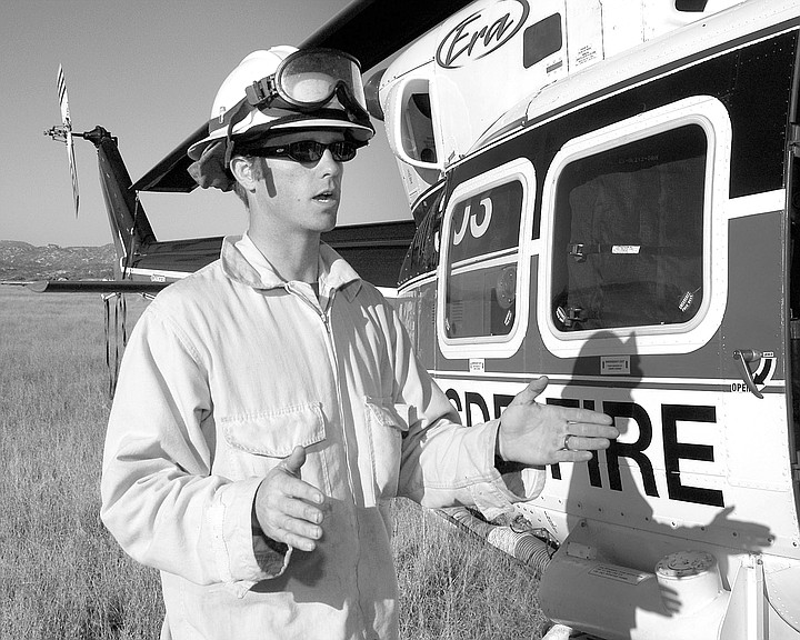
Jed Burt, a firefighter based at Gillespie Field, was on that ridge when the fire came up. A member of an eight-man California Department of Forestry "helitack" crew, he and his team had been dropped off on the ridge by a helicopter in the early stages of the fire. "When we were flying over," says Burt, standing next to the helicopter now parked at a makeshift heliport in Campo Valley, "The fire was still in Mexico and it was maybe 20 acres. It was really steep so there was nowhere for the helicopter to set down. We finally found a spot where we could set down that wasn't in the path of the fire, and they set it down, dropped the crew off, and went straight to the water draft" -- a pond in Cameron Corners -- "to try to keep it from jumping the border. And our crew started to cut some line there. But then the winds got a little too scary so they picked us back up."
After it crested, the fire started "running pretty hard" east along the ridgeline. "We were coming along holding it with engines," Scully says, "and we were actually being very successful until right around that area there where the scraper is. It had a little bit of wind coming this way [northeast], and it just drove it right across. The engines couldn't stop it."
A string of high-tension power lines running along the ridge hampered the firefighting efforts for a couple of reasons. "Not only can we not put aircraft dropping around the power lines," Scully explains, "but we can't work under the power lines because they can arc to the ground through the smoke. That happened four times yesterday. The smoke has enough moisture content with the soot and oils and such that it conducts 500,000 volts to the ground. It would turn you to toast if it were to hit you. So when we get heavy smoke production, we have to pull out from underneath the power lines."
As the firefighters pulled out and back down the hill, the fire followed them. "It got established over here, and it was pushing downhill quickly toward these houses." Scully points at a half-dozen houses dotting the hillside on the south side of 94 at quarter-mile intervals. "So now I've got another problem: I have to protect houses with the limited resources I have. So I had to pull resources off and send them down for structure protection because that's one of our primary goals -- not that it would have made any difference. Because at that time the fire was doing what it wanted to do. About that time, that's when it came up into this draw over here."
Scully points to the creek bed curving up from the south and a sweeping turn to the east. "So we had fire running down that hill toward those houses," he points southeast. "We have fire coming up the creek, and the main fire was going like crazy right along the Mexican border. By that time, the fire had taken this little breeze we're feeling right now and turned it into 35-mile-per-hour winds. Because as the air heat rises, something has to come in and replace it. So it creates indrafting, and you just get a tremendous amount of wind.
"The wind was blowing burning brands and embers down the hill and across Highway 94, where firefighters were trying to make another stand. The fire started spotting across Highway 94 up here a little bit farther. We were able to pick those spots up really quickly. This hill that we're standing on -- it spotted across here, and we picked it up. So we were shipping people from this spot to this spot to this spot."
By the time the fire had reached the road, six fixed-wing aircraft and two helicopters were making retardant and water drops on the fire. Jed Burt and his helitack team were dropped off on Highway 94 "because we are real mobile," Burt explains. "We are seven guys, and we are really fast. We don't have to carry hose and stuff, and we can jump on spots that are, like, ten-by-ten spots that just start when an ember falls. We can jump on them faster than an engine company can, and we can knock them down before they get too big. We just cut line around it real quick before it gets too big where you would have to stand back, because it is so hot."
Fast as they were, Burt and his team found it difficult to keep up with all of the little fires ignited by flying embers on the north side of 94. "Spot fires," Burt continues, "were creating a lot of problems. The wind was blowing up all the embers, and they were being carried about 500 yards across. They were starting these little fires that were getting big. So we had a bunch of spot fires that we were trying to catch."
The problem was, a seven-man helitack crew is designed to work in conjunction with the helicopter it rides in. As the crew cuts fire lines with rakes, shovels, mattocks, and chainsaws, the helicopters make periodic 360-gallon water drops on the hottest spots of the fire so that the crew can cut lines around them. "We can function without the helicopter," Burt explains, "but it really works nicely when the helicopter is right there supporting the helitack crew. But our helicopter got sent to another area of the fire that was more critical. So we were left alone."
By one in the afternoon, the fire had invaded the United States along a three-pronged front. One was running east along the border fence, another was coming north up Campo Creek, and a third came downhill to the northeast between the other two prongs. Six houses were in its path. As Burt and his helitack teams worked the spot fires north of the road, Scully decided to try to stop the latter two prongs of the main body of fire at 94. "We actually held it at the highway for the longest time... Well, it seemed like forever, but it was probably only 15 or 20 minutes. But it finally spotted across by what we call Dogpatch, that little community that's just on the other side of the railroad tracks."
Firefighters supported by helicopters paralleled the eastern prong of the fire for a couple of miles, Scully says, "before they hooked the fire back over into Mexico." Once the fire was on the Mexican side of the border, the fence "acted as a heat barrier. It deflected the heat up. The folks who were going along that fence said the fence was a real benefit."
The middle prong of the fire, coming downhill just east of the point where Campo Creek crosses the border, threatened six dwellings on the south side of the road in an area known locally as Mountain Empire. Firefighters successfully defended all six of them, losing only one long-abandoned house. But, when the middle prong reached the road, firefighters weren't able to hold it, and it crossed the road into an old, near-empty trailer park and campground alongside the creek. Jed Burt and his teammates were in the middle of this park when the fire hit it. "We were trying to keep the fire out of the campground," he explains. "There were a few semipermanent residences set up in that area, so we were trying to do what we could there. But then the wind got behind it and it took off. So we just stayed in the campground because there was fire all around us. There was a huge dirt area inside the campground there, and so we were safe."
After the fire passed through the campground, the west and middle prongs of the fire joined and started moving northeast in the direction of Campo and Cameron Corners, straddling the train tracks. A chicken ranch about two air miles west of Campo stood in its path. Without their helicopter to give them a ride, Burt and his team started walking east on 94, where a sheriff picked them up. "We got a ride with the sheriffs back down the 94 toward the chicken ranch. Because we knew they needed help there."
The sheriff's deputy dropped the crew off at a dirt road leading to the chicken ranch. "We started hiking the road, and we were saying, 'It looks like it is a ways off,' but we didn't have wheels, and the helicopter was taking care of the structure threat, so we just started hiking the road. Luckily, a local came by who lived down that road, and we asked him, 'Did you see the head of the fire down there?' and he said, 'Yeah, it is about a half mile from the chicken ranch.' And he said, 'Do you guys want a ride?' So we just hopped in the back of his truck, and he took us right to the chicken ranch, where there were engines protecting the structure."
There was also a California Department of Forestry-contracted bulldozer in the area. So the helitack crew worked in conjunction with it, started cut lines at the very head of the fire. In the meantime, back on Highway 94 in the Mountain Empire area, Scully had ordered a hose line to be laid around the northwest perimeter of the fire. He was eager to prevent the fire from burning up Hauser Mountain, directly north across the river bottom from the turnout where he's parked now, "Because once it got established on that hill up there," he explains, "our next point to stop it would have been Hauser Canyon on the other side, where we would have had zero probability of success -- narrow canyon with one little dirt road down in the bottom of it; very steep on both sides; heavy brush; hasn't burned in many, many years; one way in, one way out. After that, the fire would have been off to Lake Morena."
But by laying the hose line around that edge of the fire, and with consistent retardant drops from the airplanes, the firefighters prevented the fire from going up Hauser Mountain. By 5:30 p.m., 6000 feet of inch-and-a-half hose had been laid around the northern perimeter of the fire, 100 feet at a time. And 4000 feet had been laid around the eastern end. The two ends met at the leading edge of the fire, where Jed Burt and his helitack crewmates were working, about half a mile southwest of the chicken ranch. The team was then pulled off of the line. "When the hose lay showed up," Burt says, "there was really no need for the helitack team to be there. And we were out of water anyway because we had been on our own for a while."
The joining of the two hose lines signaled the end of the spread of the fire, though it continued to burn much later into the night. "We actually completed the fire lines," Scully says, "meaning, we had physically cut line around the whole fire at about 10:00 o'clock last night."
In the end, 960 acres burned on the U.S. side of the border. A single abandoned house was consumed. No one was injured. In addition to the 15 local engines and six aircraft originally dispatched to the fire, Scully says, "We used the county mutual-aid program for probably 30 or 35 engines from all different areas.
"You know, this fire whupped us pretty good. It whupped us all day long. Fortunately, the weather was not bad at all. If this had been a 100-degree day, with 9 percent humidity, we would have probably had a 10,000-acre fire."
Here's something you might be interested in.
It Would Turn You To Toast
How they fought 2004 Campo fire
It Would Turn You To Toast
How they fought 2004 Campo fire
CDF hand crew along Highway 94. "The wind was blowing burning brands and embers down the hill and across Highway 94, where firefighters were trying to make another stand."
Pete Scully, a battalion chief for the California Department of Forestry's fire protection agency, stands next to his camper-shelled pickup truck at a Highway 94 turnoff east of where Campo Creek turns south into Mexico, about halfway between Campo and Potrero. The hill looming on the south side of the road is completely blackened, the aftermath of a wildfire that roared through this area the day before, Monday, September 13. The dried leaves on the cottonwoods in the creek bed rustle in the afternoon wind. Each gentle puff of breeze carries the smell of soot and ash. All around, thin wisps of smoke rise from bushes still smoldering. Scully is a suntanned man in the neighborhood of 50. About six feet tall, he's wearing a yellow jumpsuit speckled with the red of fire retardant dropped from aircraft yesterday. On his head he wears a blue cap with CDF embroidered in gold letters. The sun reflects off his wraparound sunglasses as he recounts yesterday's fire, which was first reported around 10:00 a.m. "We could see the smoke, and we could see it was in Mexico. So I held off on the [large-scale] dispatch."
Pete Scully: "We can't work under the power lines because they can arc to the ground through the smoke. That happened four times yesterday. The smoke has enough moisture content with the soot and oils and such that it conducts 500,000 volts to the ground."
Instead, Scully rolled one truck out of Potrero, five miles west. "We went out to take a look and find out what the axis was going to be and whether we needed to take action. So we got in and saw that it was going to impact us. See this canyon back over here?" He points southwest to where Campo Creek, paralleled by the San Diego and Arizona Eastern railroad tracks, heads into Mexico. "If you follow that canyon down you can see where the fire started down in Mexico just at the bottom of that canyon."
Jed Burt: "We finally found a spot where we could set down that wasn't in the path of the fire, and they set it down, dropped the crew off, and went straight to the water draft" -- a pond in Cameron Corners -- "to try to keep it from jumping the border."
Asked what started the blaze, he answers, "It could have been a migrant campfire because there is a lot of illegal alien traffic that comes through there. There are also some ranches down in there. It could have been something dumped from the ranch that accidentally started a fire. It's really hard to say, and we have no right to go into Mexico to investigate.
"Anyway," he continues, "the fire was burning well, but not running very rapidly. It started burning its way a little bit east and north up the ridge, just as we'd expect it to do. Again, it was fairly mellow burning conditions, like today."
Today it's a touch over 80 degrees with moderate humidity and a light, cool breeze blowing out of the west. When he realized the fire would cross the border, Scully "ordered 15 engines, four hand crews, and two bulldozers" from the nearby rural fire protection district, California Department of Forestry, the United States Forest Service, and local volunteer departments. "We felt pretty confident," Scully continues, "that we were going to be able to stop the fire along some truck trails up here." Scully points south across the road and up the hill. On the charred mountainside, it's easy to pick out the labyrinth of dirt roads carved into the hill. "Do you see that saddle up at the top, where that old scraper is sitting? What we were trying to do is hold the fire right along that ridge line."
But a few factors made it impossible to stop the fire on the ridge overlooking the border. "As the fire got to the ridgeline," Scully says, "between the wind that was generated by the fire and the upper-level winds, it greatly increased just as it hit the top."
Scully, who acted as incident commander throughout the blaze, was parked in his truck on a border patrol road just as the fire crested the ridge and intensified. "I was parked up by that old scraper, and it was literally rocking my pickup truck back and forth. There was burning brush flying through the air. It was probably 70- to 75-mile-per-hour winds. Then the next thing was this big sheet of fire that came up over the top of us. That's how it went from this mundane little fire to boom! It was the combination of the steep slopes, the little bit of ambient wind that was in the air, and the heat generated by the convection column of the fire. It all came together just right."
Jed Burt, a firefighter based at Gillespie Field, was on that ridge when the fire came up. A member of an eight-man California Department of Forestry "helitack" crew, he and his team had been dropped off on the ridge by a helicopter in the early stages of the fire. "When we were flying over," says Burt, standing next to the helicopter now parked at a makeshift heliport in Campo Valley, "The fire was still in Mexico and it was maybe 20 acres. It was really steep so there was nowhere for the helicopter to set down. We finally found a spot where we could set down that wasn't in the path of the fire, and they set it down, dropped the crew off, and went straight to the water draft" -- a pond in Cameron Corners -- "to try to keep it from jumping the border. And our crew started to cut some line there. But then the winds got a little too scary so they picked us back up."
After it crested, the fire started "running pretty hard" east along the ridgeline. "We were coming along holding it with engines," Scully says, "and we were actually being very successful until right around that area there where the scraper is. It had a little bit of wind coming this way [northeast], and it just drove it right across. The engines couldn't stop it."
A string of high-tension power lines running along the ridge hampered the firefighting efforts for a couple of reasons. "Not only can we not put aircraft dropping around the power lines," Scully explains, "but we can't work under the power lines because they can arc to the ground through the smoke. That happened four times yesterday. The smoke has enough moisture content with the soot and oils and such that it conducts 500,000 volts to the ground. It would turn you to toast if it were to hit you. So when we get heavy smoke production, we have to pull out from underneath the power lines."
As the firefighters pulled out and back down the hill, the fire followed them. "It got established over here, and it was pushing downhill quickly toward these houses." Scully points at a half-dozen houses dotting the hillside on the south side of 94 at quarter-mile intervals. "So now I've got another problem: I have to protect houses with the limited resources I have. So I had to pull resources off and send them down for structure protection because that's one of our primary goals -- not that it would have made any difference. Because at that time the fire was doing what it wanted to do. About that time, that's when it came up into this draw over here."
Scully points to the creek bed curving up from the south and a sweeping turn to the east. "So we had fire running down that hill toward those houses," he points southeast. "We have fire coming up the creek, and the main fire was going like crazy right along the Mexican border. By that time, the fire had taken this little breeze we're feeling right now and turned it into 35-mile-per-hour winds. Because as the air heat rises, something has to come in and replace it. So it creates indrafting, and you just get a tremendous amount of wind.
"The wind was blowing burning brands and embers down the hill and across Highway 94, where firefighters were trying to make another stand. The fire started spotting across Highway 94 up here a little bit farther. We were able to pick those spots up really quickly. This hill that we're standing on -- it spotted across here, and we picked it up. So we were shipping people from this spot to this spot to this spot."
By the time the fire had reached the road, six fixed-wing aircraft and two helicopters were making retardant and water drops on the fire. Jed Burt and his helitack team were dropped off on Highway 94 "because we are real mobile," Burt explains. "We are seven guys, and we are really fast. We don't have to carry hose and stuff, and we can jump on spots that are, like, ten-by-ten spots that just start when an ember falls. We can jump on them faster than an engine company can, and we can knock them down before they get too big. We just cut line around it real quick before it gets too big where you would have to stand back, because it is so hot."
Fast as they were, Burt and his team found it difficult to keep up with all of the little fires ignited by flying embers on the north side of 94. "Spot fires," Burt continues, "were creating a lot of problems. The wind was blowing up all the embers, and they were being carried about 500 yards across. They were starting these little fires that were getting big. So we had a bunch of spot fires that we were trying to catch."
The problem was, a seven-man helitack crew is designed to work in conjunction with the helicopter it rides in. As the crew cuts fire lines with rakes, shovels, mattocks, and chainsaws, the helicopters make periodic 360-gallon water drops on the hottest spots of the fire so that the crew can cut lines around them. "We can function without the helicopter," Burt explains, "but it really works nicely when the helicopter is right there supporting the helitack crew. But our helicopter got sent to another area of the fire that was more critical. So we were left alone."
By one in the afternoon, the fire had invaded the United States along a three-pronged front. One was running east along the border fence, another was coming north up Campo Creek, and a third came downhill to the northeast between the other two prongs. Six houses were in its path. As Burt and his helitack teams worked the spot fires north of the road, Scully decided to try to stop the latter two prongs of the main body of fire at 94. "We actually held it at the highway for the longest time... Well, it seemed like forever, but it was probably only 15 or 20 minutes. But it finally spotted across by what we call Dogpatch, that little community that's just on the other side of the railroad tracks."
Firefighters supported by helicopters paralleled the eastern prong of the fire for a couple of miles, Scully says, "before they hooked the fire back over into Mexico." Once the fire was on the Mexican side of the border, the fence "acted as a heat barrier. It deflected the heat up. The folks who were going along that fence said the fence was a real benefit."
The middle prong of the fire, coming downhill just east of the point where Campo Creek crosses the border, threatened six dwellings on the south side of the road in an area known locally as Mountain Empire. Firefighters successfully defended all six of them, losing only one long-abandoned house. But, when the middle prong reached the road, firefighters weren't able to hold it, and it crossed the road into an old, near-empty trailer park and campground alongside the creek. Jed Burt and his teammates were in the middle of this park when the fire hit it. "We were trying to keep the fire out of the campground," he explains. "There were a few semipermanent residences set up in that area, so we were trying to do what we could there. But then the wind got behind it and it took off. So we just stayed in the campground because there was fire all around us. There was a huge dirt area inside the campground there, and so we were safe."
After the fire passed through the campground, the west and middle prongs of the fire joined and started moving northeast in the direction of Campo and Cameron Corners, straddling the train tracks. A chicken ranch about two air miles west of Campo stood in its path. Without their helicopter to give them a ride, Burt and his team started walking east on 94, where a sheriff picked them up. "We got a ride with the sheriffs back down the 94 toward the chicken ranch. Because we knew they needed help there."
The sheriff's deputy dropped the crew off at a dirt road leading to the chicken ranch. "We started hiking the road, and we were saying, 'It looks like it is a ways off,' but we didn't have wheels, and the helicopter was taking care of the structure threat, so we just started hiking the road. Luckily, a local came by who lived down that road, and we asked him, 'Did you see the head of the fire down there?' and he said, 'Yeah, it is about a half mile from the chicken ranch.' And he said, 'Do you guys want a ride?' So we just hopped in the back of his truck, and he took us right to the chicken ranch, where there were engines protecting the structure."
There was also a California Department of Forestry-contracted bulldozer in the area. So the helitack crew worked in conjunction with it, started cut lines at the very head of the fire. In the meantime, back on Highway 94 in the Mountain Empire area, Scully had ordered a hose line to be laid around the northwest perimeter of the fire. He was eager to prevent the fire from burning up Hauser Mountain, directly north across the river bottom from the turnout where he's parked now, "Because once it got established on that hill up there," he explains, "our next point to stop it would have been Hauser Canyon on the other side, where we would have had zero probability of success -- narrow canyon with one little dirt road down in the bottom of it; very steep on both sides; heavy brush; hasn't burned in many, many years; one way in, one way out. After that, the fire would have been off to Lake Morena."
But by laying the hose line around that edge of the fire, and with consistent retardant drops from the airplanes, the firefighters prevented the fire from going up Hauser Mountain. By 5:30 p.m., 6000 feet of inch-and-a-half hose had been laid around the northern perimeter of the fire, 100 feet at a time. And 4000 feet had been laid around the eastern end. The two ends met at the leading edge of the fire, where Jed Burt and his helitack crewmates were working, about half a mile southwest of the chicken ranch. The team was then pulled off of the line. "When the hose lay showed up," Burt says, "there was really no need for the helitack team to be there. And we were out of water anyway because we had been on our own for a while."
The joining of the two hose lines signaled the end of the spread of the fire, though it continued to burn much later into the night. "We actually completed the fire lines," Scully says, "meaning, we had physically cut line around the whole fire at about 10:00 o'clock last night."
In the end, 960 acres burned on the U.S. side of the border. A single abandoned house was consumed. No one was injured. In addition to the 15 local engines and six aircraft originally dispatched to the fire, Scully says, "We used the county mutual-aid program for probably 30 or 35 engines from all different areas.
"You know, this fire whupped us pretty good. It whupped us all day long. Fortunately, the weather was not bad at all. If this had been a 100-degree day, with 9 percent humidity, we would have probably had a 10,000-acre fire."
Comments