Here's something you might be interested in.
Ask a Hipster — Advice you didn't know you needed
Big Screen — Movie commentary
Blurt — Music's inside track
Booze News — San Diego spirits
Classical Music — Immortal beauty
Classifieds — Free and easy
Close to Home — What it’s like on the street where you live
Cover Stories — Front-page features
Drinks All Around — Bartenders' drink recipes
Excerpts — Literary and spiritual excerpts
Feast! — Food & drink reviews
Feature Stories — Local news & stories
Fishing Report — What’s getting hooked from ship and shore
From the Archives — Spotlight on the past
Golden Dreams — Talk of the town
The Gonzo Report — Making the musical scene, or at least reporting from it
Letters — Our inbox
Movies@Home — Local movie buffs share favorites
Movie Reviews — Our critics' picks and pans
Musician Interviews — Up close with local artists
Neighborhood News from Stringers — Hyperlocal news
News Ticker — News & politics
Obermeyer — San Diego politics illustrated
Outdoors — Weekly changes in flora and fauna
Overheard in San Diego — Eavesdropping illustrated
Poetry — The old and the new
Reader Travel — Travel section built by travelers
Reading — The hunt for intellectuals
Roam-O-Rama — SoCal's best hiking/biking trails
San Diego Beer — Inside San Diego suds
SD on the QT — Almost factual news
Sheep and Goats — Places of worship
Special Issues — The best of
Street Style — San Diego streets have style
Surf Diego — Real stories from those braving the waves
Theater — On stage in San Diego this week
Tin Fork — Silver spoon alternative
Under the Radar — Matt Potter's undercover work
Unforgettable — Long-ago San Diego
Unreal Estate — San Diego's priciest pads
Your Week — Daily event picks
Pick your way over boulder mazes on the Wonderland of Rocks traverse through Joshua Tree National Park.
Millions of years of tectonic uplift, weathering, and erosion created the maze of monzogranite boulders in the Wonderland of Rocks section of Joshua Tree National Park. Wherever you look in this region, your mind is dazzled by oversized loaf-like stacks of rocks, by boulders arranged in columns and spires, or by huge granite domes.
To see the best of it, you can try the 5.7-mile, one-way hiking traverse across the Wonderland of Rocks known by some as the "Wonderland Connection." Make no mistake, this is no easy stroll. At times you'll feel like an ant trying to negotiate a fiercely jumbled landscape. You must be adept at both boulder hopping and scrambling across tilted rock surfaces. Much of the travel involves meticulously lowering yourself downward over angular boulders -- not recommended for the faint of heart. Having a topographic map (available at the park's visitors' center) and map-reading skills is an excellent idea!
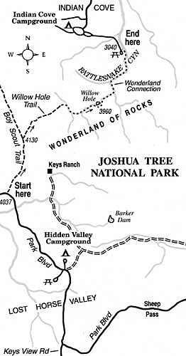
You begin at the Wonderland backcountry board (kiosk) on the north side of Park Boulevard (a.k.a. Quail Springs Road), 11 miles southeast of the town of Joshua Tree. This is 0.7 mile east of Quail Springs Picnic Area and 2.3 miles northwest of Hidden Valley Campground. You'll end at the Indian Cove camp/picnic area, west and south of the town of Twentynine Palms.
From the Wonderland backcountry board, follow the Boy Scout trail (a dirt road) 1.4 miles north across sandy flats dotted with Joshua trees to the Willow Hole Trail, intersecting on the right. Follow the Willow Hole Trail northeast to where it enters a dry wash, then continue downhill in the wash. The wash soon becomes a canyon bottom flanked by stacks of boulders. At 3.5 miles you arrive at Willow Hole -- some large pools flanked by a screen of willows.
Following a beaten-down path, you then work your way through the willows on the right, over a low ridge, and across a gap between two rock piles. Follow the narrow canyon bottom below, which will carry water draining from the pools at Willow Hole once the winter rains come. The remaining travel is entirely downhill, but progress is soon impeded as you negotiate a canyon section clogged with boulders.
At 0.7 mile beyond Willow Hole, a north-flowing tributary joins on the right. Stay in the main canyon as it veers north and descends sharply for 0.3 mile to join Rattlesnake Canyon. Exercise care while descending this hazardous stretch.
Once you reach Rattlesnake Canyon, only a bit more than a mile of hiking remains. The going is easy for a while as you follow the sandy wash downhill (northeast). Some cottonwood trees brighten the otherwise desolate scene of sand and soaring stone walls. As the canyon bends left for a final descent to the flats of Indian Cove below, you face more episodes of serious scrambling. Keeping to the left-side canyon wall, you work your way around a slotlike canyon worn in the rock. Down in the bottom of the slot are potholes worn by the abrasive action of flash flooding. Only a bit more scrambling and a short walk down the canyon's sandy wash takes you to the end of the hike -- the picnic area at Indian Cove.
Here's something you might be interested in.
Pick your way over boulder mazes on the Wonderland of Rocks traverse through Joshua Tree National Park.
Pick your way over boulder mazes on the Wonderland of Rocks traverse through Joshua Tree National Park.
Millions of years of tectonic uplift, weathering, and erosion created the maze of monzogranite boulders in the Wonderland of Rocks section of Joshua Tree National Park. Wherever you look in this region, your mind is dazzled by oversized loaf-like stacks of rocks, by boulders arranged in columns and spires, or by huge granite domes.
To see the best of it, you can try the 5.7-mile, one-way hiking traverse across the Wonderland of Rocks known by some as the "Wonderland Connection." Make no mistake, this is no easy stroll. At times you'll feel like an ant trying to negotiate a fiercely jumbled landscape. You must be adept at both boulder hopping and scrambling across tilted rock surfaces. Much of the travel involves meticulously lowering yourself downward over angular boulders -- not recommended for the faint of heart. Having a topographic map (available at the park's visitors' center) and map-reading skills is an excellent idea!
You begin at the Wonderland backcountry board (kiosk) on the north side of Park Boulevard (a.k.a. Quail Springs Road), 11 miles southeast of the town of Joshua Tree. This is 0.7 mile east of Quail Springs Picnic Area and 2.3 miles northwest of Hidden Valley Campground. You'll end at the Indian Cove camp/picnic area, west and south of the town of Twentynine Palms.
From the Wonderland backcountry board, follow the Boy Scout trail (a dirt road) 1.4 miles north across sandy flats dotted with Joshua trees to the Willow Hole Trail, intersecting on the right. Follow the Willow Hole Trail northeast to where it enters a dry wash, then continue downhill in the wash. The wash soon becomes a canyon bottom flanked by stacks of boulders. At 3.5 miles you arrive at Willow Hole -- some large pools flanked by a screen of willows.
Following a beaten-down path, you then work your way through the willows on the right, over a low ridge, and across a gap between two rock piles. Follow the narrow canyon bottom below, which will carry water draining from the pools at Willow Hole once the winter rains come. The remaining travel is entirely downhill, but progress is soon impeded as you negotiate a canyon section clogged with boulders.
At 0.7 mile beyond Willow Hole, a north-flowing tributary joins on the right. Stay in the main canyon as it veers north and descends sharply for 0.3 mile to join Rattlesnake Canyon. Exercise care while descending this hazardous stretch.
Once you reach Rattlesnake Canyon, only a bit more than a mile of hiking remains. The going is easy for a while as you follow the sandy wash downhill (northeast). Some cottonwood trees brighten the otherwise desolate scene of sand and soaring stone walls. As the canyon bends left for a final descent to the flats of Indian Cove below, you face more episodes of serious scrambling. Keeping to the left-side canyon wall, you work your way around a slotlike canyon worn in the rock. Down in the bottom of the slot are potholes worn by the abrasive action of flash flooding. Only a bit more scrambling and a short walk down the canyon's sandy wash takes you to the end of the hike -- the picnic area at Indian Cove.
Comments