Here's something you might be interested in.
Ask a Hipster — Advice you didn't know you needed
Big Screen — Movie commentary
Blurt — Music's inside track
Booze News — San Diego spirits
Classical Music — Immortal beauty
Classifieds — Free and easy
Cover Stories — Front-page features
Drinks All Around — Bartenders' drink recipes
Excerpts — Literary and spiritual excerpts
Feast! — Food & drink reviews
Feature Stories — Local news & stories
Fishing Report — What’s getting hooked from ship and shore
From the Archives — Spotlight on the past
Golden Dreams — Talk of the town
The Gonzo Report — Making the musical scene, or at least reporting from it
Letters — Our inbox
Movies@Home — Local movie buffs share favorites
Movie Reviews — Our critics' picks and pans
Musician Interviews — Up close with local artists
Neighborhood News from Stringers — Hyperlocal news
News Ticker — News & politics
Obermeyer — San Diego politics illustrated
Outdoors — Weekly changes in flora and fauna
Overheard in San Diego — Eavesdropping illustrated
Poetry — The old and the new
Reader Travel — Travel section built by travelers
Reading — The hunt for intellectuals
Roam-O-Rama — SoCal's best hiking/biking trails
San Diego Beer — Inside San Diego suds
SD on the QT — Almost factual news
Sheep and Goats — Places of worship
Special Issues — The best of
Street Style — San Diego streets have style
Surf Diego — Real stories from those braving the waves
Theater — On stage in San Diego this week
Tin Fork — Silver spoon alternative
Under the Radar — Matt Potter's undercover work
Unforgettable — Long-ago San Diego
Unreal Estate — San Diego's priciest pads
Your Week — Daily event picks
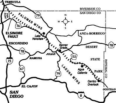
Follow the trace of the Elsinore Fault through San Diego County's mountains and desert.
Like a subterranean knife-wound, the Elsinore Fault slices across the heart of San Diego County's backcountry, promising an earth-shaking jolt or two during the next few centuries. Sputtering movements over geologic time along its opposing sides have shaped much of the county's interior topography, and that particular topography has more or less determined where you can easily drive and where you cannot. Here's how you can trace our county's share of the Elsinore Fault -- quickly by car or much more leisurely by bicycle.
Start by heading south from Temecula on Pala Road (a.k.a. Pala-Temecula Road). The fault passes under the road near the Pala Road summit just south of the county line, but with no visible trace at the surface. Turn left at Highway 76 and continue generally east, below the steep ramparts of Palomar Mountain -- itself a "fault-block" range thrust upward several thousand feet. The Lake Henshaw reservoir lies ahead, occupying a broad, mountain-ringed basin of the sort geologists call a "sag pond." The fault runs near the reservoir's south shore.
When you reach Highway 79, turn right. Ahead about four miles, the road elbows to the right at a summit and you pass over the fault once again. Turn left (east) on Highway 78 at Santa Ysabel, and proceed uphill toward Julian.
Beyond the small but touristy hamlet of Julian, follow Highway 78 east down the corkscrew Banner Grade. While steering down this notorious stretch (or struggling to keep your cookies if you're a back-seat passenger), notice the conspicuous, terrace-like traces of the fault at eye level on the slope to the left, across Banner Canyon. These traces have been made dramatically more visible in the aftermath of last summer's mammoth Pines fire, which was sparked down in Banner Canyon itself.
At the bottom of Banner Grade, Elsinore Fault skips over a low pass, heading southeast. Staying on the pavement, however, you must detour east and later southeast, following Highways 78 and S-2 into the desert. By the time you reach the Box Canyon historic site on S-2, you're back on the fault again.
The Elsinore Fault and Highway S-2 are nearly coincident over the next 25 to 30 miles. Look for fault traces skipping over the rocky hills southeast of the hot springs at Agua Caliente, and also along the mountain slopes to the right, about four miles past Agua Caliente. Finally, pull off at the Carrizo Overlook, just beyond Sweeney Pass. Down in the maw of the Carrizo Badlands, the fault skims across the base of a prominent slope. Farther south and east, the fault sinks beneath the desert sands. Continue driving southeast to Ocotillo, where you can pick up Interstate 8 for an expeditious return to San Diego.
Here's something you might be interested in.
Follow the trace of the Elsinore Fault through San Diego County's mountains and desert.
Follow the trace of the Elsinore Fault through San Diego County's mountains and desert.
Like a subterranean knife-wound, the Elsinore Fault slices across the heart of San Diego County's backcountry, promising an earth-shaking jolt or two during the next few centuries. Sputtering movements over geologic time along its opposing sides have shaped much of the county's interior topography, and that particular topography has more or less determined where you can easily drive and where you cannot. Here's how you can trace our county's share of the Elsinore Fault -- quickly by car or much more leisurely by bicycle.
Start by heading south from Temecula on Pala Road (a.k.a. Pala-Temecula Road). The fault passes under the road near the Pala Road summit just south of the county line, but with no visible trace at the surface. Turn left at Highway 76 and continue generally east, below the steep ramparts of Palomar Mountain -- itself a "fault-block" range thrust upward several thousand feet. The Lake Henshaw reservoir lies ahead, occupying a broad, mountain-ringed basin of the sort geologists call a "sag pond." The fault runs near the reservoir's south shore.
When you reach Highway 79, turn right. Ahead about four miles, the road elbows to the right at a summit and you pass over the fault once again. Turn left (east) on Highway 78 at Santa Ysabel, and proceed uphill toward Julian.
Beyond the small but touristy hamlet of Julian, follow Highway 78 east down the corkscrew Banner Grade. While steering down this notorious stretch (or struggling to keep your cookies if you're a back-seat passenger), notice the conspicuous, terrace-like traces of the fault at eye level on the slope to the left, across Banner Canyon. These traces have been made dramatically more visible in the aftermath of last summer's mammoth Pines fire, which was sparked down in Banner Canyon itself.
At the bottom of Banner Grade, Elsinore Fault skips over a low pass, heading southeast. Staying on the pavement, however, you must detour east and later southeast, following Highways 78 and S-2 into the desert. By the time you reach the Box Canyon historic site on S-2, you're back on the fault again.
The Elsinore Fault and Highway S-2 are nearly coincident over the next 25 to 30 miles. Look for fault traces skipping over the rocky hills southeast of the hot springs at Agua Caliente, and also along the mountain slopes to the right, about four miles past Agua Caliente. Finally, pull off at the Carrizo Overlook, just beyond Sweeney Pass. Down in the maw of the Carrizo Badlands, the fault skims across the base of a prominent slope. Farther south and east, the fault sinks beneath the desert sands. Continue driving southeast to Ocotillo, where you can pick up Interstate 8 for an expeditious return to San Diego.