Here's something you might be interested in.
Ask a Hipster — Advice you didn't know you needed
Big Screen — Movie commentary
Blurt — Music's inside track
Booze News — San Diego spirits
Classical Music — Immortal beauty
Classifieds — Free and easy
Cover Stories — Front-page features
Drinks All Around — Bartenders' drink recipes
Excerpts — Literary and spiritual excerpts
Feast! — Food & drink reviews
Feature Stories — Local news & stories
Fishing Report — What’s getting hooked from ship and shore
From the Archives — Spotlight on the past
Golden Dreams — Talk of the town
The Gonzo Report — Making the musical scene, or at least reporting from it
Letters — Our inbox
Movies@Home — Local movie buffs share favorites
Movie Reviews — Our critics' picks and pans
Musician Interviews — Up close with local artists
Neighborhood News from Stringers — Hyperlocal news
News Ticker — News & politics
Obermeyer — San Diego politics illustrated
Outdoors — Weekly changes in flora and fauna
Overheard in San Diego — Eavesdropping illustrated
Poetry — The old and the new
Reader Travel — Travel section built by travelers
Reading — The hunt for intellectuals
Roam-O-Rama — SoCal's best hiking/biking trails
San Diego Beer — Inside San Diego suds
SD on the QT — Almost factual news
Sheep and Goats — Places of worship
Special Issues — The best of
Street Style — San Diego streets have style
Surf Diego — Real stories from those braving the waves
Theater — On stage in San Diego this week
Tin Fork — Silver spoon alternative
Under the Radar — Matt Potter's undercover work
Unforgettable — Long-ago San Diego
Unreal Estate — San Diego's priciest pads
Your Week — Daily event picks
Palomar prescribed burn watched carefully
Fire by design
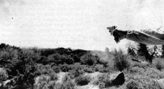
White and Robbins decide to try to ignite the brush on this particular hillside by using a flare gun.
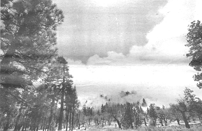
The mountain appears to have been hit by a bomb. Smoke is billowing upward in thick streams that flow together into one vast column hundreds of feet high. On the hillside below, bright orange flames are ravaging the brush in a wide patch that looks like an open wound.
“One of the dangerous things about a big wildfire is that the head starts to create its own weather."
You can hear the faint beating of the helicopter even before it appears over the ridge. Finally it comes into view, a tiny white creature lost in the expanse of brush and sky and smoke here on the eastern flank of Palomar Mountain. When it reaches the burning area, the helicopter suddenly and rather unexpectedly banks away and begins to descend the mountain, hugging a steep ridge as it moves away from the fire. Near the bottom of the ridge it turns and heads up toward the fire again, only to descend once more along another ridge. In a few minutes thin lines of smoke appear where the helicopter has been, and soon rows of orange flames dance upward as the dense brush catches and begins to burn. And the helicopter works on, descending one ridge after another like a spider spinning webs of flame.
White: the Laguna fire started in chaparral that was twenty-six years old.
It makes you feel just a little uneasy to see the hillside deliberately torched like this. It doesn't help much to know the helicopter belongs to the United States Forest Service, an agency better known for a stern-faced bear who admonishes motorists and campers, “Remember, only you can prevent forest fires.” From our vantage point on a hillside a quarter mile away from the fire, we watch with perverse fascination as the helicopter drips out line after line of flame from a barrel suspended beneath its belly, carrying out what the forest service refers to as a “prescribed burn.”
It has been speculated that the high levels of turpines and acetones in chaparral plants exist to help promote a fire.
There are about a dozen people watching in all; most of them are forest service personnel, but they have been joined by several employees of the nearby Palomar Observatory, a couple of photographers, and a few others.
It makes you feel just a little uneasy to see the hillside deliberately torched like this.
Anxious for information, I accost a young man with tousled blond hair who has a forest service patch on his shirt sleeve. “The size of this burn is 500 acres, but the objective is to actually burn only about sixty-five percent of that,” he tells me. It turns out that he is Steve Clauson, the head ranger for the Palomar district of the Cleveland National Forest, where the burn is taking place. “There will be some places burned totally, some places burned partially, and some places not burned at all. The reason we’re burning is primarily to improve the wildlife habitat, but it’s also for fuel reduction; some of the chaparral out there is sixty to seventy years old.”
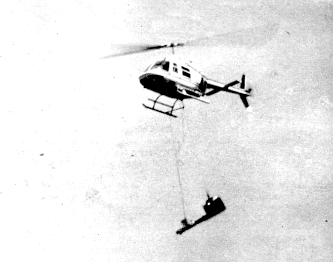
The helicopter works on, descending one ridge after another like a spider spinning webs of flame.
Below us a dirt road leads out along a ridge to the east. The road is well south of the main fire, but a plume of smoke is rising along it, and through binoculars I can see men clad in yellow and orange fire suits working there. “They’re reburning that fuel break, keeping it clear,” Clauson explains, “but they’re really here for one reason: just in case the fire gets out of control.” Clauson goes on to explain that the prescribed-fire manager, the man calling the shots, as he puts it, is in a jeep somewhere on the main ridge. The lighting boss, who is directing the helicopter pilot, is with one of the hand crews on the dirt road below us. In all there are five hand crews and six engines on the scene, Clauson says. And then he pauses, looking out at the flames and smoke in the distance. “The moisture in the brush is pretty high at this time of year,” he observes quietly. “If this was August or September there’s no way you’d stop it.”
The organization of the fire-fighting personnel is reminiscent of the military, and so is the operation of the prescribed burn itself. It’s difficult not to think of air strikes as the helicopter slowly maneuvers back and forth across the hillside, setting it afire; the substance used to ignite the brush, jellied gasoline, is even similar to napalm. Suddenly a shout goes up from the people around me as a particularly dense patch of brush catches and the fire spreads to a nearby oak tree. The flames quickly reach heights of twenty or thirty feet, but soon die down. (Later, I learn that one of the goals of this fire was to avoid burning the few trees on this dry, brush-covered hillside. The flaming oak was an accident, a casualty in a generally successful campaign.)
Through drifting smoke I can see a small, dark, hovering shape — a hawk. It appears to be close to a dangerously hot part of the fire, and for a moment I wonder if it has become confused by the smoke and heat. But it continues to hover there for a long time, apparently unharmed and apparently hunting. A few days after the fire I spoke to Steve Widowski. a wildlife biologist for the Cleveland s Palomar district, and asked him about the hawk. During the fire Widowski was on the dirt road with the lighting boss, helping to direct the helicopter. He saw hawks in the smoke, he said, “and a lot of ravens. They weren’t confused, they were feeding. During a fire like this a lot of small mammals lose their cover, and they become easy prey. We even saw a few birds with rodents in their mouths flying away from the fire.”
The afternoon wears on, and the helicopter wheels and banks among the clouds of smoke. Finally it turns for the last time and flies off for a refueling pad, hidden from view over a ridge to the east. The fire burns on after the helicopter leaves, but more and more slowly. Now and then a light breeze bears the smoke away, and as if a curtain has lifted we can glimpse some of the burned patches of ground. They are still smoking, an ashy gray. The old-growth chaparral that was here can burn uncontrollably hot and fast when it is allowed to accumulate unchecked over a period of several decades; if a wildfire were to reach this area now, it would have a hard time moving through these newly created “islands” of burned brush. In a few months deer will come to browse on the young shoots that spring up in the clearings, and hunters will follow the deer.
Prescribed burns such as this one are not new in the United States — they have been used for years to thin trees and reduce the fire danger in timber stands in the South and the Northwest, for example — but they are almost unknown in California’s highly combustible chaparral. Large-scale burning of this brush type has taken place only in the last three years, nearly all of it in the Laguna-Morena Demonstration Area, a specially designated, 130,000-acre tract within the Cleveland National Forest, in San Diego County’s Laguna Mountains. Now the forest service is preparing to use the techniques they have refined here on chaparral lands in national forests all over California. And, using the same techniques, the California Department of Forestry will soon implement a massive program of prescribed burns on more than ten million acres of chaparral-covered private and public land in the state. “Prescribed burning is going to be increasing dramatically in the next few years,” a forest service official told me not long ago. “The government is officially in the burn business now.”
It’s not as if Smokey the Bear is going to be replaced as the symbol of fire prevention by a wide-eyed ranger squirting liquid fire from a helicopter. As a matter of fact, the public will still be fed the same old saws about stamping out cigarette butts and pouring water on campfires. But fire officials have increasingly come to realize that the only way to reduce the high cost of putting out wildfires — an expense that can run as high as one million dollars a day — is to reduce the size of the fire. And in many areas the only practical way to do that is to reduce the amount of old and dead wood on the ground through a systematic program of burning.
The programs are not without their critics; some people claim that fire agencies have converted too zealously to prescribed burning. It is still an experimental process, they caution, and one that could cause as much damage as good. But even these critics agree it is time fire was recognized as part of the natural order, as important to the life of the chaparral as sunlight and rain.
Manzanita, chamise, sage, scrub oak, ceanothus, flat-top buckwheat, laurel and mountain sumac, lemonadeberry, holly leaf cherry, mountain mahogany. When you go out into Southern California’s brush-covered hills, these are what you see. They’re large shrubs, most of them, with thick, rubbery or waxy leaves. They’re well adapted to getting and retaining water any way they can in this fogbound but generally arid climate, and they’re well adapted to fire.
um
It has been speculated that the high levels of turpines and acetones in chaparral plants exist to help promote a fire. Many of the species are geared to resprout from root crowns when the upper branches are burned away; most of the others scatter seeds in the soil that “sit there waiting for a fire to come along,” says Tom White. “The fire cracks the seed coat and allows water to get in and germinate the seed. Fire plays different roles in various ecosystems in the western United States, but chaparral requires a particularly hot fire that actually kills the existing plants. It’s not only fire-adapted, it’s fire-dependent.”
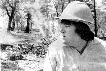
White, the acting program manager for the Laguna-Morena Demonstration Area, is a man whose glasses and soft-spoken manner contrast sharply with his big, husky frame. One warm, clear April morning a few weeks ago, he and I climbed into a forest service truck and drove up into the Laguna Mountains for a look at the demonstration area. A burn had been scheduled for this particular day, and White had promised me that we would be able to see it from the front lines, up close.
White had become the acting manager of the demonstration area just one month earlier, when the previous manager. White’s boss, moved on to a new post with the forest service in Oregon. The search for a permanent replacement has not yet begun, but White could be considered for the job. At twenty-seven he has a B.A. in forest management from Northern Arizona University, and an M.A. from San Diego State University in geology and environmental planning. While he was at SDSU he worked as a student intern with the forest service, and his master’s thesis was on the Laguna-Morena Demonstration Area.
We turned off I-8 onto the Sunrise Highway, and made our way slowly up • into the mountains. Bright blue scrub jays glided across the road as we went. In answer to my questions. White explained that the concept of prescribed fire originally got its start in the southern United States, where long-leaf pines were harvested for their soft wood. The pines never grew back after being logged, and eventually it was found they depend on fire to kill a bacteria that inhibits their growth. Since all fires in the area were being put out, the bacteria was keeping the young pines down indefinitely.
But even as fire began to be used to help long-leaf pines regenerate in the South, the concept of suppressing all wildfires in other areas persisted. The forest service had always promoted the idea of fire as a destructive force, and it wasn’t easy to change. One local fire official I talked to recently summed up the history of fire suppression in Southern California this way: “Fire was a natural part of this area before the Indians came, and certainly while they were here. Then the white man came and built his stupid house out in the middle of the brush, and all of a sudden fire was not considered natural any more.”
One event went a long way toward changing this way of thinking: the Laguna fire of 1970. During a Santa Ana that year a power line near the Sunrise Highway in the Cleveland National Forest blew down, and sparks ignited the nearby brush. Pushed on by the hot, dry winds, the fire quickly flared out of control and burned an incredible 176,000 acres in only three days. It killed six people, destroyed 382 homes, and was stopped at the very edge of the San Diego metropolitan area only after tens of millions of dollars had been spent in putting it out. Several people later charged that the forest service’s longstanding policy of putting out all wildfires had resulted in an unnaturally high build-up of dead chaparral which actually aided the Laguna fire. The state government appointed a task force to study ways of reducing the threat of wildfires, and out of this grew, in 1977, the Laguna-Morena Demonstration Area.
Tom White remembers the Laguna fire; he was a senior at Point Loma High School when it broke out. “That’s what got me interested in forestry in the first place,” he says. “What I remember primarily is the news reports and the huge cloud of smoke that hung over the city for three days. It was the first time I realized the forest service even existed in San Diego, and that these large fires were occurring.”
Today White knows that the Laguna fire started in chaparral that was twenty-six years old, and quickly spread into a large area that hadn’t burned for at least seventy years, and perhaps not for as long as one hundred years. “One of our objectives in Laguna-Morena is to break up the area into blocks of different-age brush — break up the continuity of the fuels,” he explains. “The main reason this hasn’t been done in chaparral before is because of the difficulty in controlling it. Old chaparral burns extremely readily because of the accumulation of dead material. But young chaparral is hard to burn; the percentage of live material is high, and the live material has a high moisture content. So that’s another one of our objectives, really, to keep the chaparral in a younger, more vigorous state.”
White and I turn off the highway onto a dirt road and make our way through a dense forest of oak and pine. The LMDA extends roughly from Morena Reservoir in the south to Lake Cuyamaca in the north, and from Guatay and Descanso in the west to the eastern slope of the Laguna Mountains. We are in the heart of it now, near Mount Laguna itself. We round a few turns, and suddenly there is smoke hanging in the air. Soon we can see pockets of flame burning near the road, but still no one is in sight. White explains that this is an “understory” burn — one that consumes only downed wood and a few trees. “That’s doing what an understory burn should do — creep along like that,” he remarks casually, glancing out the truck window.
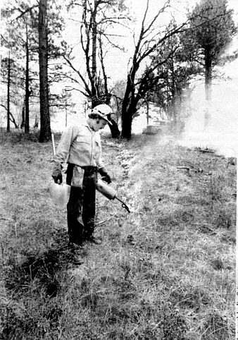
But we are looking for the fire crew and its boss. Bob Robbins, who are scheduled to burn a nearby knoll of old chaparral, and so we move on. Down a rutted din track through the trees, across a clearing, around a turn — and suddenly, off to our right, the whole forest seems to be on fire. Heavy smoke is drifting through the trees, but through it we can see the forms of the fire crew in their yellow fire-retardant suits. They are carrying around canisters the size of watering cans, methodically dripping a burning liquid onto the dry needles and leaves that have collected beneath the trees. The leaves catch almost instantly and, in some places, the fire has spread to nearby shrubs and trees that are now bathed in flame.
“I’ll go look for Bob Robbins; he must be around here somewhere,” says White, parking the truck and getting out. I get out after him. The air temperature seems to rise suddenly fifteen or twenty degrees. Tiny bits of ash come floating through the air and land on my shirt. The smell of smoke — particularly the crisp, dry scent of burning oak — is everywhere. But there is no sound other than the crackling and snapping of the fire.
White returns a few minutes later with the news that Robbins is somewhere further ahead, and we climb back into the truck. As we drive slowly through the burning forest. White tells me, “The drip torches the crew is using out there use a mixture of five parts diesel and one part gasoline. It’s important not to reverse that mixture.” He smiles faintly, tongue in cheek. “The diesel burns a lot more slowly. A fire like this will kill some of the trees and leave the ones that are strongest and best suited to survive. If the understory builds up, it creates a hotter fire, and that can damage a lot of trees.”
Eventually we meet up with another forest service truck, driven by Robbins, who was supervising some understory burning a half mile away. He turns around and we follow him along a dirt road, up out of the forest into a clearing. To our right a hill covered with dense chaparral rises perhaps two hundred feet. Today it is going to be burned. White and Robbins briefly discuss the plan of action for burning the hill, and among the things I hear Robbins say is, “The humidity is about forty percent right now, a little too high for good burning. It started out this morning at about twenty-six.”
For the forest service, prescribed burning has become a science; an imperfect science, perhaps, but a science nonetheless. Every fire has a specific prescription involving relative humidities, air temperatures, moisture content of the brush or wood to be burned, and wind speeds. Using a complicated model developed by forest service researchers, the amount of brush in any given part of a forest is analyzed according to its type and the thickness of its branches. The soil type and degree and direction of slope are taken into account, too, since these factors can also influence a fire. Sometimes the brush on an individual slope is analyzed for weeks before a big burn, in order to gain an idea of what the trends in its moisture content are. The amount of brush to be burned depends on the objectives — a fire for wildlife habitat improvement might burn only five to thirty percent of the brush in a given area, while a fire for fuel reduction or range improvement might burn as much as eighty percent — but the idea is to know exactly what will burn, when, and for how long.
Ultimately the planning process results in a “prescription window” — a day or two when the fire can take place with minimum risk and maximum control. But the prescriptions are still subject to human error. In the spring of last year a prescribed fire in Michigan’s Huron-Manistee National Forest got out of control in high winds. Twenty-five thousand acres burned and one fire fighter was killed before it was put out. It was a mistake the forest service would just as soon not repeat.
“The bottom line on control is keeping down the intensity of the fire,” White explains. “And that can be done partly through the lighting pattern, estimating how much the fuel levels deviate from the average, judging the slopes, and a lot of other variables. That’s the art of prescribed burning. What it comes down to is the decisions of the firing boss on the ground.”
Now, White and Robbins decide to try to ignite the brush on this particular hillside by using a flare gun. The decision to use the gun has been made partly to accommodate photographs for a weekly newspaper, and partly because the brush is so dense it would be difficult for the fire crews to penetrate it with their drip torches. Neither White nor Robbins expects the flare gun to work here, however; their combined opinion is that the humidity and the moisture in the brush today are simply too high.
White removes the flare gun from a black box in the back of his truck, a box that looks remarkably similar to the bag a doctor might bring with him on a house call. But here White is making an outdoor call, a chaparral call, with a gun that shoots big, specially designed bullets with flares on the tips. The explosion is every bit as loud as a regular gun, and the flares go a long way, sailing off into the brush like shooting stars. One, two, three, a half dozen shells are fired into the chaparral on the hill. We wait for a few minutes, but nothing happens. The flares smoke for a while where they fall, and then go out. A few more shots, one of which hits a boulder and caroms high into the air, produce the same results.
“Doesn’t look like it really wants to burn today,” White comments, packing the flare gun back into its black box.
“You should have seen it yesterday,” Robbins tells him. “Yesterday was just a beautiful day for burning.”
“Part of the reason I object to prescribed burning,” says Tom Oberbauer, “is because it’s like a religion, a dogma they’re preaching; people have to spread it everywhere. It’s as if the entire state of California is now a practice area or something.”
Oberbauer is the president of the local chapter of the California Native Plant Society, and he is also an environmental management specialist in the county’s environmental planning division. He agrees that prescribed burning is a good way to reduce fire suppression costs — “It’s certainly better than reducing fuels with herbicides,” he told me — but he insists that it should only be used sparingly, in carefully monitored situations. “The CDF [California Department of Forestry] and the forest service are not doing adequate studies beforehand to find out what the impacts are going to be,” he says. “Fires in the spring, when birds are nesting and plants are flowering, could have long-term effects. Or when they use that helicopter to drip that liquid fuel out, it will leave residual chemicals in the system. What impact does that have on the wildlife and plants?” One of Oberbauer’s bitterest complaints is that many of the environmental impact reports for prescribed burns list the benefits of prescribed burning without even analyzing the potential negative impacts. He singles out the report prepared by the CDF for its new prescribed burning program (officially known as a “chaparral management program”) as a particularly good example of this. The CDF’s program, mandated by law to get under way July 1, 1981, is designed to reduce fire danger by aiding ranchers and other land-owners who want to clear chaparral from their land through burning. The CDF will conduct the burn and pay up to ninety percent of the tab, depending on how much the public will benefit from the fire.
According to the CDF and the forest service, chaparral that is twenty years old or older poses a fire danger. Oberbauer, though, says it might take fifty years or more for the chaparral to reach its maximum health and fertility. If the chaparral is burned every twenty years, he says, it could do irreversible damage to the vegetation. “They should set aside patches of ground,” he suggests, “and burn them at different intervals to find out what the long-term effects are. They should have done this a long time ago. The thing that’s crucial is to determine what the natural frequency of fires in an area is, and that’s something no one really understands yet.”
But Len Newell, head of the CDF’s chaparral management program, says that the wording of the new law makes Oberbauer’s arguments somewhat moot. Newell was the original director of the Laguna-Morena Demonstration Area, and is now on loan to the CDF from the forest service to get the state’s prescribed burning started. The law applies mostly to private land, Newell said in a telephone interview from his office in Sacramento recently, which means that the frequency of fire will depend “on the objectives set by the landowner. If you’re trying to maintain grassland, you might want to burn as often as every two or three years. Oberbauer’s approach is pure ecology, and that’s fine in state parks or national parks where the land has been set aside mainly for the protection of the resources. But when you’re talking about private land where the burn is being done at the owner’s request, the question of what the natural fire cycle is becomes academic, if not downright unimportant.” Newell admitted that the CDF program will also cover some state-owned land, but claimed that fire agencies have enough information to make some “crude assumptions” about what Fire frequencies will protect the chaparral while still reducing fire danger. Tom White agrees. “Twenty years is just sort of an average fire frequency for chaparral in general,” he says. “In our more detailed project planning we look at the specific brush types and what the effects of a Fire would be. We don’t know every effect that will occur, it’s true. We’re going to be learning as we go along. But if we were to continue with our program of fire suppression instead, we’d be doing something that’s even more unnatural.”
Newell, White, and other fire officials are quick to point out that prescribed burns often benefit wildlife. When the chaparral in a given area partially burns, they say, new habitat opens up which attracts a greater diversity of birds and mammals. “The vast majority of species prefer the cover provided by old-growth chaparral together with the nutrition of the more vigorous, younger growth,” explains Steve Widowski, the Cleveland’s wildlife biologist for the Palomar district. “The idea is to get the species to reproduce at a maximum rate, because the higher the reproductive rate is the more genetic diversity there is and the more adaptable the species are.”
That,at least, is the classic biological theory, but not everyone is convinced prescribed burning will work so smoothly in practice. Mike Evans, a biologist and coordinator for the county on environmental impact reports, recently told me that forest service and CDF reports talk about prescribed fires benefiting only two species: deer and quail, both game species. “What I would like to see is a thorough study of all the species that will benefit and all the species that will not,” said Evans. “They have just not stated these things in their documents, and I think they’re incomplete.”
Evans complained that simply increasing the number of species can be misleading; it’s not always for the good. “If you built a subdivision in the middle of the chaparral you’d increase the number of birds, for example, because you’d attract starlings and house sparrows that weren’t there before. A more diverse habitat could introduce more predators, too, which could be disastrous for endangered species in the area.
“It’s not that I’m against prescribed burning, it's just that I think they’re rushing in before they really know what the effects are,” he continued, echoing Oberbauer’s reservations. “I’m sure part of the reason is due to finances. But it’s a very large program, and they should carry out some studies first.”
Widowski admitted there have been no significant studies done in the Laguna-Morena Demonstration Area on what effects prescribed burns have on wildlife. (The demonstration area is out of his jurisdiction, in another district of the Cleveland that currently has no wildlife biologist.) That’s one of the things the forest service plans to study in the future, he said. He himself is beginning to monitor the effects of the recent burn on Palomar Mountain,
he told me; among other things he will survey populations of birds common to chaparral such as wrentits, thrashers, and scrub jays, and he will study deer use. “We want to see which species come back and which ones increase,” he explained. “There’s a lot we don’t know, but we feel prescribed burning is a definite improvement over what we were doing. At least now we’re managing the chaparral instead of just sitting on it.”
White puts the box containing the flare gun back into his truck. It is nearly noon, and the fire crews are going to wait until after lunch to burn the chaparral. Since it could be several hours before the operation gets started, White and I decide to move on. Robbins has told us that there is some heavy burning going on on the other side of the hill, where he was earlier; it will give us a good idea what the chaparral burn will look like later on.
We circle the hill slowly in the truck, looking for the place Robbins mentioned. Soon we come upon a fire crew lounging by the side of the road, lunch boxes open. Less than one hundred yards away thick smoke is billowing out of the trees, but they seem unconcerned. A few minutes later White pulls the truck off to the side of the road, and we get out to walk up to the fire.
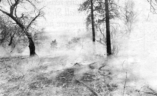
The fallen leaves underfoot make dry crunching sounds as we climb the hillside through the trees. White says you can tell the intensity of fire by the color of the smoke: bluish-white is the coolest, brown is hotter, black smoke is the hottest of all. Where we are headed now the smoke is mostly bluish-white, but here and there angry brown strands writhe up toward the sky. We continue on, and suddenly stumble almost into the middle of the fire.
Whatever it is that people find fascinating about fire hasn’t lost its appeal in the thousands of years since humans first put sparks to use. From where we are standing we can see low, ragged flames creeping along the ground among the tree trunks. Nearby a few old shrubs burn slowly, their dead branches decorated with tiny, delicate rosettes of flame. And beyond, where the fire is hottest, huge pillars of flame are rising and tearing away like solar flares, mingling with the smoke and heat above the treetops. Even from thirty feet away the heat is so intense that we break out into a sweat, and are forced to turn away.
White comments that the fire is moving away from us, up the hillside. It forms a head and moves with the wind, he says, and then he grabs a stick nearby to show me what he means. With the stick. White rakes some burning embers onto a nearby patch of unburned leaves. They ignite almost immediately, and in only seconds the fire has formed an elongated triangle with the head at the long point. It is moving up the hillside with the wind, a wildfire in miniature.
“One of the dangerous things about a big wildfire is that the head starts to create its own weather," White says as we watch the flames dance across the leaves. “The heat combines with wind.currents and forms eddies — a fire storm." In the Laguna fire, the swirling eddies formed a ball of flame that rolled down at least one hill, incinerating everything in its path. And last year, at the head of a big fire in San Bernardino County, White saw a fire storm that resembled a tornado: high winds created a whirling column of fire. As White watched, the column passed over a barn, and the barn exploded.
Within a few minutes I have seen all the fire I care to for now, and White and I make our way back down the hillside to the truck. On the way back to his office White wants to show me a place near Kitchen Creek, on the eastern slope of the Laguna Mountains. It was burned several years earlier in one of the first prescribed chaparral fires in Southern California, and White says it is a good place to see some of the effects on the brush.
As we drive out onto the Sunrise Highway again, he points to the canyon where the Laguna fire first broke out nearly eleven years ago. Soon we pass a meadow which, he tells me, was a dense forest of oak before the Laguna fire. Now only blackened stumps remain, dotting the field like some grim parody of a corn field.
Wildfires have proved to be monumentally expensive to put out, and it is one of the great hopes of government officials that prescribed burns will eventually lower the cost of fire fighting. During a wildfire, money for men and equipment often comes initially from a forest service emergency fund. But on a big fire the dollars sometimes flow so fast and in such large amounts, and from so many different agencies, that it is virtually impossible to pin down exactly how much has been spent or where it came from. “Essentially your budget on a big wildfire is unlimited," White explains. “You’re not going to run out of money in the middle of the fire."
In contrast, money for prescribed burns is allocated on the basis of strict research and projections, and there are the usual problems in getting funds for what, on its face, appears to be just another expense.
But White says that one recent UC Davis study indicated prescribed fires would prove to be three times cheaper than fire suppression. “Every study I’ve seen shows that we’ll save money in the long run,” he tells me as we wind down Kitchen Creek Road. “If we stop one wildfire in San Diego County using prescribed burns, for instance, we’ll pay for our fire management costs for fifteen or twenty years.’ ’
But the problem is convincing people of that in the short run. The budget for the demonstration area this year is $140,000, and White ruefully admits it is significantly higher than the budget for previous years. (The figure includes White’s salary, the salaries of two public information specialists, and the planning that goes into prescribed burns in the demonstration area, but not the cost of men and equipment needed to carry them out.) The budget for the CDF’s new program is somewhat heftier, with four million dollars committed for the year beginning July 1. Len Newell says this will allow for burning about 120,000 acres a year, and will include the cost of refitting several helicopters with drip torches.
According to White, later this year the forest service plans to begin a 10,000-acre project that will include several prescribed burns near Thing Mountain in the demonstration area. The goals are to continue to break up the area into blocks of brush with different ages and moisture contents, and to study the effects of prescribed burning on wildlife. “We still have to learn how weather affects specific sites, and how the fire behaves under various conditions,” he says. “Ultimately we hope to have a ‘library’ of how each fuel type burns under certain conditions.”
At a bend in the road White pulls the truck over on a gravel shoulder, and we get out. Below us Kitchen Creek pours across bedrock granite on its way eastward, and we have a good view of the surrounding hills, covered with boulders and chaparral. There is hardly a tree in sight. White points to one steep hillside to the west that has large patches of brush on it. From where we are standing a half mile away, some of the patches look green, others tan or brown. “That’s a natural mosaic in the brush,” he explains. “When we first conducted a burn out here, ninety percent of those brown patches burned — they’re mostly buckwheat. But when the fire reached the green patches, which are mostly chamise, it went right out. At that time of year the chamise had a higher moisture content, and it just wouldn’t burn.
“That taught us a lot. We learned that in some cases we wouldn’t even need to construct fuel breaks if we did the right planning, because the pattern of the vegetation types gives you all the control over the fire you really do need.”
We linger for a moment in the bright afternoon sun, looking out across the green hills. After a while White observes, “In the future, there will probably be escaped wildfires in the chaparral, but there will be fewer of them, and they’ll be smaller. And maybe some day we’ll see a wildfire burn into an area that’s been treated with prescribed fire, and instead of hitting it with everything we’ve got we’ll just sit back and watch it go out.” He chuckles, savoring the thought. “And we’ll be able to say, ‘Well, look at that!’ ”
Here's something you might be interested in.
Palomar prescribed burn watched carefully
Fire by design
Palomar prescribed burn watched carefully
Fire by design
White and Robbins decide to try to ignite the brush on this particular hillside by using a flare gun.
The mountain appears to have been hit by a bomb. Smoke is billowing upward in thick streams that flow together into one vast column hundreds of feet high. On the hillside below, bright orange flames are ravaging the brush in a wide patch that looks like an open wound.
“One of the dangerous things about a big wildfire is that the head starts to create its own weather."
You can hear the faint beating of the helicopter even before it appears over the ridge. Finally it comes into view, a tiny white creature lost in the expanse of brush and sky and smoke here on the eastern flank of Palomar Mountain. When it reaches the burning area, the helicopter suddenly and rather unexpectedly banks away and begins to descend the mountain, hugging a steep ridge as it moves away from the fire. Near the bottom of the ridge it turns and heads up toward the fire again, only to descend once more along another ridge. In a few minutes thin lines of smoke appear where the helicopter has been, and soon rows of orange flames dance upward as the dense brush catches and begins to burn. And the helicopter works on, descending one ridge after another like a spider spinning webs of flame.
White: the Laguna fire started in chaparral that was twenty-six years old.
It makes you feel just a little uneasy to see the hillside deliberately torched like this. It doesn't help much to know the helicopter belongs to the United States Forest Service, an agency better known for a stern-faced bear who admonishes motorists and campers, “Remember, only you can prevent forest fires.” From our vantage point on a hillside a quarter mile away from the fire, we watch with perverse fascination as the helicopter drips out line after line of flame from a barrel suspended beneath its belly, carrying out what the forest service refers to as a “prescribed burn.”
It has been speculated that the high levels of turpines and acetones in chaparral plants exist to help promote a fire.
There are about a dozen people watching in all; most of them are forest service personnel, but they have been joined by several employees of the nearby Palomar Observatory, a couple of photographers, and a few others.
It makes you feel just a little uneasy to see the hillside deliberately torched like this.
Anxious for information, I accost a young man with tousled blond hair who has a forest service patch on his shirt sleeve. “The size of this burn is 500 acres, but the objective is to actually burn only about sixty-five percent of that,” he tells me. It turns out that he is Steve Clauson, the head ranger for the Palomar district of the Cleveland National Forest, where the burn is taking place. “There will be some places burned totally, some places burned partially, and some places not burned at all. The reason we’re burning is primarily to improve the wildlife habitat, but it’s also for fuel reduction; some of the chaparral out there is sixty to seventy years old.”
The helicopter works on, descending one ridge after another like a spider spinning webs of flame.
Below us a dirt road leads out along a ridge to the east. The road is well south of the main fire, but a plume of smoke is rising along it, and through binoculars I can see men clad in yellow and orange fire suits working there. “They’re reburning that fuel break, keeping it clear,” Clauson explains, “but they’re really here for one reason: just in case the fire gets out of control.” Clauson goes on to explain that the prescribed-fire manager, the man calling the shots, as he puts it, is in a jeep somewhere on the main ridge. The lighting boss, who is directing the helicopter pilot, is with one of the hand crews on the dirt road below us. In all there are five hand crews and six engines on the scene, Clauson says. And then he pauses, looking out at the flames and smoke in the distance. “The moisture in the brush is pretty high at this time of year,” he observes quietly. “If this was August or September there’s no way you’d stop it.”
The organization of the fire-fighting personnel is reminiscent of the military, and so is the operation of the prescribed burn itself. It’s difficult not to think of air strikes as the helicopter slowly maneuvers back and forth across the hillside, setting it afire; the substance used to ignite the brush, jellied gasoline, is even similar to napalm. Suddenly a shout goes up from the people around me as a particularly dense patch of brush catches and the fire spreads to a nearby oak tree. The flames quickly reach heights of twenty or thirty feet, but soon die down. (Later, I learn that one of the goals of this fire was to avoid burning the few trees on this dry, brush-covered hillside. The flaming oak was an accident, a casualty in a generally successful campaign.)
Through drifting smoke I can see a small, dark, hovering shape — a hawk. It appears to be close to a dangerously hot part of the fire, and for a moment I wonder if it has become confused by the smoke and heat. But it continues to hover there for a long time, apparently unharmed and apparently hunting. A few days after the fire I spoke to Steve Widowski. a wildlife biologist for the Cleveland s Palomar district, and asked him about the hawk. During the fire Widowski was on the dirt road with the lighting boss, helping to direct the helicopter. He saw hawks in the smoke, he said, “and a lot of ravens. They weren’t confused, they were feeding. During a fire like this a lot of small mammals lose their cover, and they become easy prey. We even saw a few birds with rodents in their mouths flying away from the fire.”
The afternoon wears on, and the helicopter wheels and banks among the clouds of smoke. Finally it turns for the last time and flies off for a refueling pad, hidden from view over a ridge to the east. The fire burns on after the helicopter leaves, but more and more slowly. Now and then a light breeze bears the smoke away, and as if a curtain has lifted we can glimpse some of the burned patches of ground. They are still smoking, an ashy gray. The old-growth chaparral that was here can burn uncontrollably hot and fast when it is allowed to accumulate unchecked over a period of several decades; if a wildfire were to reach this area now, it would have a hard time moving through these newly created “islands” of burned brush. In a few months deer will come to browse on the young shoots that spring up in the clearings, and hunters will follow the deer.
Prescribed burns such as this one are not new in the United States — they have been used for years to thin trees and reduce the fire danger in timber stands in the South and the Northwest, for example — but they are almost unknown in California’s highly combustible chaparral. Large-scale burning of this brush type has taken place only in the last three years, nearly all of it in the Laguna-Morena Demonstration Area, a specially designated, 130,000-acre tract within the Cleveland National Forest, in San Diego County’s Laguna Mountains. Now the forest service is preparing to use the techniques they have refined here on chaparral lands in national forests all over California. And, using the same techniques, the California Department of Forestry will soon implement a massive program of prescribed burns on more than ten million acres of chaparral-covered private and public land in the state. “Prescribed burning is going to be increasing dramatically in the next few years,” a forest service official told me not long ago. “The government is officially in the burn business now.”
It’s not as if Smokey the Bear is going to be replaced as the symbol of fire prevention by a wide-eyed ranger squirting liquid fire from a helicopter. As a matter of fact, the public will still be fed the same old saws about stamping out cigarette butts and pouring water on campfires. But fire officials have increasingly come to realize that the only way to reduce the high cost of putting out wildfires — an expense that can run as high as one million dollars a day — is to reduce the size of the fire. And in many areas the only practical way to do that is to reduce the amount of old and dead wood on the ground through a systematic program of burning.
The programs are not without their critics; some people claim that fire agencies have converted too zealously to prescribed burning. It is still an experimental process, they caution, and one that could cause as much damage as good. But even these critics agree it is time fire was recognized as part of the natural order, as important to the life of the chaparral as sunlight and rain.
Manzanita, chamise, sage, scrub oak, ceanothus, flat-top buckwheat, laurel and mountain sumac, lemonadeberry, holly leaf cherry, mountain mahogany. When you go out into Southern California’s brush-covered hills, these are what you see. They’re large shrubs, most of them, with thick, rubbery or waxy leaves. They’re well adapted to getting and retaining water any way they can in this fogbound but generally arid climate, and they’re well adapted to fire.
um
It has been speculated that the high levels of turpines and acetones in chaparral plants exist to help promote a fire. Many of the species are geared to resprout from root crowns when the upper branches are burned away; most of the others scatter seeds in the soil that “sit there waiting for a fire to come along,” says Tom White. “The fire cracks the seed coat and allows water to get in and germinate the seed. Fire plays different roles in various ecosystems in the western United States, but chaparral requires a particularly hot fire that actually kills the existing plants. It’s not only fire-adapted, it’s fire-dependent.”
White, the acting program manager for the Laguna-Morena Demonstration Area, is a man whose glasses and soft-spoken manner contrast sharply with his big, husky frame. One warm, clear April morning a few weeks ago, he and I climbed into a forest service truck and drove up into the Laguna Mountains for a look at the demonstration area. A burn had been scheduled for this particular day, and White had promised me that we would be able to see it from the front lines, up close.
White had become the acting manager of the demonstration area just one month earlier, when the previous manager. White’s boss, moved on to a new post with the forest service in Oregon. The search for a permanent replacement has not yet begun, but White could be considered for the job. At twenty-seven he has a B.A. in forest management from Northern Arizona University, and an M.A. from San Diego State University in geology and environmental planning. While he was at SDSU he worked as a student intern with the forest service, and his master’s thesis was on the Laguna-Morena Demonstration Area.
We turned off I-8 onto the Sunrise Highway, and made our way slowly up • into the mountains. Bright blue scrub jays glided across the road as we went. In answer to my questions. White explained that the concept of prescribed fire originally got its start in the southern United States, where long-leaf pines were harvested for their soft wood. The pines never grew back after being logged, and eventually it was found they depend on fire to kill a bacteria that inhibits their growth. Since all fires in the area were being put out, the bacteria was keeping the young pines down indefinitely.
But even as fire began to be used to help long-leaf pines regenerate in the South, the concept of suppressing all wildfires in other areas persisted. The forest service had always promoted the idea of fire as a destructive force, and it wasn’t easy to change. One local fire official I talked to recently summed up the history of fire suppression in Southern California this way: “Fire was a natural part of this area before the Indians came, and certainly while they were here. Then the white man came and built his stupid house out in the middle of the brush, and all of a sudden fire was not considered natural any more.”
One event went a long way toward changing this way of thinking: the Laguna fire of 1970. During a Santa Ana that year a power line near the Sunrise Highway in the Cleveland National Forest blew down, and sparks ignited the nearby brush. Pushed on by the hot, dry winds, the fire quickly flared out of control and burned an incredible 176,000 acres in only three days. It killed six people, destroyed 382 homes, and was stopped at the very edge of the San Diego metropolitan area only after tens of millions of dollars had been spent in putting it out. Several people later charged that the forest service’s longstanding policy of putting out all wildfires had resulted in an unnaturally high build-up of dead chaparral which actually aided the Laguna fire. The state government appointed a task force to study ways of reducing the threat of wildfires, and out of this grew, in 1977, the Laguna-Morena Demonstration Area.
Tom White remembers the Laguna fire; he was a senior at Point Loma High School when it broke out. “That’s what got me interested in forestry in the first place,” he says. “What I remember primarily is the news reports and the huge cloud of smoke that hung over the city for three days. It was the first time I realized the forest service even existed in San Diego, and that these large fires were occurring.”
Today White knows that the Laguna fire started in chaparral that was twenty-six years old, and quickly spread into a large area that hadn’t burned for at least seventy years, and perhaps not for as long as one hundred years. “One of our objectives in Laguna-Morena is to break up the area into blocks of different-age brush — break up the continuity of the fuels,” he explains. “The main reason this hasn’t been done in chaparral before is because of the difficulty in controlling it. Old chaparral burns extremely readily because of the accumulation of dead material. But young chaparral is hard to burn; the percentage of live material is high, and the live material has a high moisture content. So that’s another one of our objectives, really, to keep the chaparral in a younger, more vigorous state.”
White and I turn off the highway onto a dirt road and make our way through a dense forest of oak and pine. The LMDA extends roughly from Morena Reservoir in the south to Lake Cuyamaca in the north, and from Guatay and Descanso in the west to the eastern slope of the Laguna Mountains. We are in the heart of it now, near Mount Laguna itself. We round a few turns, and suddenly there is smoke hanging in the air. Soon we can see pockets of flame burning near the road, but still no one is in sight. White explains that this is an “understory” burn — one that consumes only downed wood and a few trees. “That’s doing what an understory burn should do — creep along like that,” he remarks casually, glancing out the truck window.
But we are looking for the fire crew and its boss. Bob Robbins, who are scheduled to burn a nearby knoll of old chaparral, and so we move on. Down a rutted din track through the trees, across a clearing, around a turn — and suddenly, off to our right, the whole forest seems to be on fire. Heavy smoke is drifting through the trees, but through it we can see the forms of the fire crew in their yellow fire-retardant suits. They are carrying around canisters the size of watering cans, methodically dripping a burning liquid onto the dry needles and leaves that have collected beneath the trees. The leaves catch almost instantly and, in some places, the fire has spread to nearby shrubs and trees that are now bathed in flame.
“I’ll go look for Bob Robbins; he must be around here somewhere,” says White, parking the truck and getting out. I get out after him. The air temperature seems to rise suddenly fifteen or twenty degrees. Tiny bits of ash come floating through the air and land on my shirt. The smell of smoke — particularly the crisp, dry scent of burning oak — is everywhere. But there is no sound other than the crackling and snapping of the fire.
White returns a few minutes later with the news that Robbins is somewhere further ahead, and we climb back into the truck. As we drive slowly through the burning forest. White tells me, “The drip torches the crew is using out there use a mixture of five parts diesel and one part gasoline. It’s important not to reverse that mixture.” He smiles faintly, tongue in cheek. “The diesel burns a lot more slowly. A fire like this will kill some of the trees and leave the ones that are strongest and best suited to survive. If the understory builds up, it creates a hotter fire, and that can damage a lot of trees.”
Eventually we meet up with another forest service truck, driven by Robbins, who was supervising some understory burning a half mile away. He turns around and we follow him along a dirt road, up out of the forest into a clearing. To our right a hill covered with dense chaparral rises perhaps two hundred feet. Today it is going to be burned. White and Robbins briefly discuss the plan of action for burning the hill, and among the things I hear Robbins say is, “The humidity is about forty percent right now, a little too high for good burning. It started out this morning at about twenty-six.”
For the forest service, prescribed burning has become a science; an imperfect science, perhaps, but a science nonetheless. Every fire has a specific prescription involving relative humidities, air temperatures, moisture content of the brush or wood to be burned, and wind speeds. Using a complicated model developed by forest service researchers, the amount of brush in any given part of a forest is analyzed according to its type and the thickness of its branches. The soil type and degree and direction of slope are taken into account, too, since these factors can also influence a fire. Sometimes the brush on an individual slope is analyzed for weeks before a big burn, in order to gain an idea of what the trends in its moisture content are. The amount of brush to be burned depends on the objectives — a fire for wildlife habitat improvement might burn only five to thirty percent of the brush in a given area, while a fire for fuel reduction or range improvement might burn as much as eighty percent — but the idea is to know exactly what will burn, when, and for how long.
Ultimately the planning process results in a “prescription window” — a day or two when the fire can take place with minimum risk and maximum control. But the prescriptions are still subject to human error. In the spring of last year a prescribed fire in Michigan’s Huron-Manistee National Forest got out of control in high winds. Twenty-five thousand acres burned and one fire fighter was killed before it was put out. It was a mistake the forest service would just as soon not repeat.
“The bottom line on control is keeping down the intensity of the fire,” White explains. “And that can be done partly through the lighting pattern, estimating how much the fuel levels deviate from the average, judging the slopes, and a lot of other variables. That’s the art of prescribed burning. What it comes down to is the decisions of the firing boss on the ground.”
Now, White and Robbins decide to try to ignite the brush on this particular hillside by using a flare gun. The decision to use the gun has been made partly to accommodate photographs for a weekly newspaper, and partly because the brush is so dense it would be difficult for the fire crews to penetrate it with their drip torches. Neither White nor Robbins expects the flare gun to work here, however; their combined opinion is that the humidity and the moisture in the brush today are simply too high.
White removes the flare gun from a black box in the back of his truck, a box that looks remarkably similar to the bag a doctor might bring with him on a house call. But here White is making an outdoor call, a chaparral call, with a gun that shoots big, specially designed bullets with flares on the tips. The explosion is every bit as loud as a regular gun, and the flares go a long way, sailing off into the brush like shooting stars. One, two, three, a half dozen shells are fired into the chaparral on the hill. We wait for a few minutes, but nothing happens. The flares smoke for a while where they fall, and then go out. A few more shots, one of which hits a boulder and caroms high into the air, produce the same results.
“Doesn’t look like it really wants to burn today,” White comments, packing the flare gun back into its black box.
“You should have seen it yesterday,” Robbins tells him. “Yesterday was just a beautiful day for burning.”
“Part of the reason I object to prescribed burning,” says Tom Oberbauer, “is because it’s like a religion, a dogma they’re preaching; people have to spread it everywhere. It’s as if the entire state of California is now a practice area or something.”
Oberbauer is the president of the local chapter of the California Native Plant Society, and he is also an environmental management specialist in the county’s environmental planning division. He agrees that prescribed burning is a good way to reduce fire suppression costs — “It’s certainly better than reducing fuels with herbicides,” he told me — but he insists that it should only be used sparingly, in carefully monitored situations. “The CDF [California Department of Forestry] and the forest service are not doing adequate studies beforehand to find out what the impacts are going to be,” he says. “Fires in the spring, when birds are nesting and plants are flowering, could have long-term effects. Or when they use that helicopter to drip that liquid fuel out, it will leave residual chemicals in the system. What impact does that have on the wildlife and plants?” One of Oberbauer’s bitterest complaints is that many of the environmental impact reports for prescribed burns list the benefits of prescribed burning without even analyzing the potential negative impacts. He singles out the report prepared by the CDF for its new prescribed burning program (officially known as a “chaparral management program”) as a particularly good example of this. The CDF’s program, mandated by law to get under way July 1, 1981, is designed to reduce fire danger by aiding ranchers and other land-owners who want to clear chaparral from their land through burning. The CDF will conduct the burn and pay up to ninety percent of the tab, depending on how much the public will benefit from the fire.
According to the CDF and the forest service, chaparral that is twenty years old or older poses a fire danger. Oberbauer, though, says it might take fifty years or more for the chaparral to reach its maximum health and fertility. If the chaparral is burned every twenty years, he says, it could do irreversible damage to the vegetation. “They should set aside patches of ground,” he suggests, “and burn them at different intervals to find out what the long-term effects are. They should have done this a long time ago. The thing that’s crucial is to determine what the natural frequency of fires in an area is, and that’s something no one really understands yet.”
But Len Newell, head of the CDF’s chaparral management program, says that the wording of the new law makes Oberbauer’s arguments somewhat moot. Newell was the original director of the Laguna-Morena Demonstration Area, and is now on loan to the CDF from the forest service to get the state’s prescribed burning started. The law applies mostly to private land, Newell said in a telephone interview from his office in Sacramento recently, which means that the frequency of fire will depend “on the objectives set by the landowner. If you’re trying to maintain grassland, you might want to burn as often as every two or three years. Oberbauer’s approach is pure ecology, and that’s fine in state parks or national parks where the land has been set aside mainly for the protection of the resources. But when you’re talking about private land where the burn is being done at the owner’s request, the question of what the natural fire cycle is becomes academic, if not downright unimportant.” Newell admitted that the CDF program will also cover some state-owned land, but claimed that fire agencies have enough information to make some “crude assumptions” about what Fire frequencies will protect the chaparral while still reducing fire danger. Tom White agrees. “Twenty years is just sort of an average fire frequency for chaparral in general,” he says. “In our more detailed project planning we look at the specific brush types and what the effects of a Fire would be. We don’t know every effect that will occur, it’s true. We’re going to be learning as we go along. But if we were to continue with our program of fire suppression instead, we’d be doing something that’s even more unnatural.”
Newell, White, and other fire officials are quick to point out that prescribed burns often benefit wildlife. When the chaparral in a given area partially burns, they say, new habitat opens up which attracts a greater diversity of birds and mammals. “The vast majority of species prefer the cover provided by old-growth chaparral together with the nutrition of the more vigorous, younger growth,” explains Steve Widowski, the Cleveland’s wildlife biologist for the Palomar district. “The idea is to get the species to reproduce at a maximum rate, because the higher the reproductive rate is the more genetic diversity there is and the more adaptable the species are.”
That,at least, is the classic biological theory, but not everyone is convinced prescribed burning will work so smoothly in practice. Mike Evans, a biologist and coordinator for the county on environmental impact reports, recently told me that forest service and CDF reports talk about prescribed fires benefiting only two species: deer and quail, both game species. “What I would like to see is a thorough study of all the species that will benefit and all the species that will not,” said Evans. “They have just not stated these things in their documents, and I think they’re incomplete.”
Evans complained that simply increasing the number of species can be misleading; it’s not always for the good. “If you built a subdivision in the middle of the chaparral you’d increase the number of birds, for example, because you’d attract starlings and house sparrows that weren’t there before. A more diverse habitat could introduce more predators, too, which could be disastrous for endangered species in the area.
“It’s not that I’m against prescribed burning, it's just that I think they’re rushing in before they really know what the effects are,” he continued, echoing Oberbauer’s reservations. “I’m sure part of the reason is due to finances. But it’s a very large program, and they should carry out some studies first.”
Widowski admitted there have been no significant studies done in the Laguna-Morena Demonstration Area on what effects prescribed burns have on wildlife. (The demonstration area is out of his jurisdiction, in another district of the Cleveland that currently has no wildlife biologist.) That’s one of the things the forest service plans to study in the future, he said. He himself is beginning to monitor the effects of the recent burn on Palomar Mountain,
he told me; among other things he will survey populations of birds common to chaparral such as wrentits, thrashers, and scrub jays, and he will study deer use. “We want to see which species come back and which ones increase,” he explained. “There’s a lot we don’t know, but we feel prescribed burning is a definite improvement over what we were doing. At least now we’re managing the chaparral instead of just sitting on it.”
White puts the box containing the flare gun back into his truck. It is nearly noon, and the fire crews are going to wait until after lunch to burn the chaparral. Since it could be several hours before the operation gets started, White and I decide to move on. Robbins has told us that there is some heavy burning going on on the other side of the hill, where he was earlier; it will give us a good idea what the chaparral burn will look like later on.
We circle the hill slowly in the truck, looking for the place Robbins mentioned. Soon we come upon a fire crew lounging by the side of the road, lunch boxes open. Less than one hundred yards away thick smoke is billowing out of the trees, but they seem unconcerned. A few minutes later White pulls the truck off to the side of the road, and we get out to walk up to the fire.
The fallen leaves underfoot make dry crunching sounds as we climb the hillside through the trees. White says you can tell the intensity of fire by the color of the smoke: bluish-white is the coolest, brown is hotter, black smoke is the hottest of all. Where we are headed now the smoke is mostly bluish-white, but here and there angry brown strands writhe up toward the sky. We continue on, and suddenly stumble almost into the middle of the fire.
Whatever it is that people find fascinating about fire hasn’t lost its appeal in the thousands of years since humans first put sparks to use. From where we are standing we can see low, ragged flames creeping along the ground among the tree trunks. Nearby a few old shrubs burn slowly, their dead branches decorated with tiny, delicate rosettes of flame. And beyond, where the fire is hottest, huge pillars of flame are rising and tearing away like solar flares, mingling with the smoke and heat above the treetops. Even from thirty feet away the heat is so intense that we break out into a sweat, and are forced to turn away.
White comments that the fire is moving away from us, up the hillside. It forms a head and moves with the wind, he says, and then he grabs a stick nearby to show me what he means. With the stick. White rakes some burning embers onto a nearby patch of unburned leaves. They ignite almost immediately, and in only seconds the fire has formed an elongated triangle with the head at the long point. It is moving up the hillside with the wind, a wildfire in miniature.
“One of the dangerous things about a big wildfire is that the head starts to create its own weather," White says as we watch the flames dance across the leaves. “The heat combines with wind.currents and forms eddies — a fire storm." In the Laguna fire, the swirling eddies formed a ball of flame that rolled down at least one hill, incinerating everything in its path. And last year, at the head of a big fire in San Bernardino County, White saw a fire storm that resembled a tornado: high winds created a whirling column of fire. As White watched, the column passed over a barn, and the barn exploded.
Within a few minutes I have seen all the fire I care to for now, and White and I make our way back down the hillside to the truck. On the way back to his office White wants to show me a place near Kitchen Creek, on the eastern slope of the Laguna Mountains. It was burned several years earlier in one of the first prescribed chaparral fires in Southern California, and White says it is a good place to see some of the effects on the brush.
As we drive out onto the Sunrise Highway again, he points to the canyon where the Laguna fire first broke out nearly eleven years ago. Soon we pass a meadow which, he tells me, was a dense forest of oak before the Laguna fire. Now only blackened stumps remain, dotting the field like some grim parody of a corn field.
Wildfires have proved to be monumentally expensive to put out, and it is one of the great hopes of government officials that prescribed burns will eventually lower the cost of fire fighting. During a wildfire, money for men and equipment often comes initially from a forest service emergency fund. But on a big fire the dollars sometimes flow so fast and in such large amounts, and from so many different agencies, that it is virtually impossible to pin down exactly how much has been spent or where it came from. “Essentially your budget on a big wildfire is unlimited," White explains. “You’re not going to run out of money in the middle of the fire."
In contrast, money for prescribed burns is allocated on the basis of strict research and projections, and there are the usual problems in getting funds for what, on its face, appears to be just another expense.
But White says that one recent UC Davis study indicated prescribed fires would prove to be three times cheaper than fire suppression. “Every study I’ve seen shows that we’ll save money in the long run,” he tells me as we wind down Kitchen Creek Road. “If we stop one wildfire in San Diego County using prescribed burns, for instance, we’ll pay for our fire management costs for fifteen or twenty years.’ ’
But the problem is convincing people of that in the short run. The budget for the demonstration area this year is $140,000, and White ruefully admits it is significantly higher than the budget for previous years. (The figure includes White’s salary, the salaries of two public information specialists, and the planning that goes into prescribed burns in the demonstration area, but not the cost of men and equipment needed to carry them out.) The budget for the CDF’s new program is somewhat heftier, with four million dollars committed for the year beginning July 1. Len Newell says this will allow for burning about 120,000 acres a year, and will include the cost of refitting several helicopters with drip torches.
According to White, later this year the forest service plans to begin a 10,000-acre project that will include several prescribed burns near Thing Mountain in the demonstration area. The goals are to continue to break up the area into blocks of brush with different ages and moisture contents, and to study the effects of prescribed burning on wildlife. “We still have to learn how weather affects specific sites, and how the fire behaves under various conditions,” he says. “Ultimately we hope to have a ‘library’ of how each fuel type burns under certain conditions.”
At a bend in the road White pulls the truck over on a gravel shoulder, and we get out. Below us Kitchen Creek pours across bedrock granite on its way eastward, and we have a good view of the surrounding hills, covered with boulders and chaparral. There is hardly a tree in sight. White points to one steep hillside to the west that has large patches of brush on it. From where we are standing a half mile away, some of the patches look green, others tan or brown. “That’s a natural mosaic in the brush,” he explains. “When we first conducted a burn out here, ninety percent of those brown patches burned — they’re mostly buckwheat. But when the fire reached the green patches, which are mostly chamise, it went right out. At that time of year the chamise had a higher moisture content, and it just wouldn’t burn.
“That taught us a lot. We learned that in some cases we wouldn’t even need to construct fuel breaks if we did the right planning, because the pattern of the vegetation types gives you all the control over the fire you really do need.”
We linger for a moment in the bright afternoon sun, looking out across the green hills. After a while White observes, “In the future, there will probably be escaped wildfires in the chaparral, but there will be fewer of them, and they’ll be smaller. And maybe some day we’ll see a wildfire burn into an area that’s been treated with prescribed fire, and instead of hitting it with everything we’ve got we’ll just sit back and watch it go out.” He chuckles, savoring the thought. “And we’ll be able to say, ‘Well, look at that!’ ”
Comments