Sponsored
Sponsored
Juniper Canyon Open Space is mainly an urban remnant of the local native coastal sage scrub, with some intermingling of chaparral and some weedy growth along the trail. The trail itself varies from a narrow path to a partially overgrown, dirt service road going between manholes of the sewer main that runs beneath the bottom of the canyon. The trail south of Juniper Street has more natural growth than the northern portion, where escaped plantings from yards have intruded extensively.
From the north, the trail starts as an inconspicuous path. An oleander bush, noted for its pretty flowers and poisonous vegetation, borders the west side of the entrance. Toward the other side is the native bladder-pod, with narrow gray-green leaves and the swollen seed pods that give it its name. Not far off is the prostrate snake-cholla cactus and sacred datura, or jimsonweed, another toxic plant. Bordering the trail are pepper trees with bunches of small pink berries, that when the papery pink outer coating is rubbed off, reveal the “pepper-corns” within (black when ripe, green when not). The ones with dark green leaves are Brazilian pepper; the ones with narrow, light-green, curving leaves are Peruvian pepper, formerly called California pepper, since it was so commonly planted here ever since it was brought to the state by the padres of the first missions. The gray-leafed trees with dark berries are various varieties of olive.
After walking 0.1 mile is the official sign declaring this an open-space park. Just before the sign is a jade plant with its succulent oval leaves, a standard of early San Diego landscaping. Further on, the low reddish succulent ground cover is crystalline ice plant from South Africa. Downhill is a prickly-pear cactus with giant pads and inconspicuous spines. This is Indian fig cactus (Opuntia ficus-indica). Different types of prickly-pear cactus have been brought here from Central and South America for food and decoration, often hybridizing with native prickly pears, but this is the only one to have naturalized intact in any numbers. Along the bottom, where drainage collects, is wavy-leafed dock that dries to a distinctive rust color, and cockleburs with those sticky, hooked seedpods that inspired the invention of Velcro.
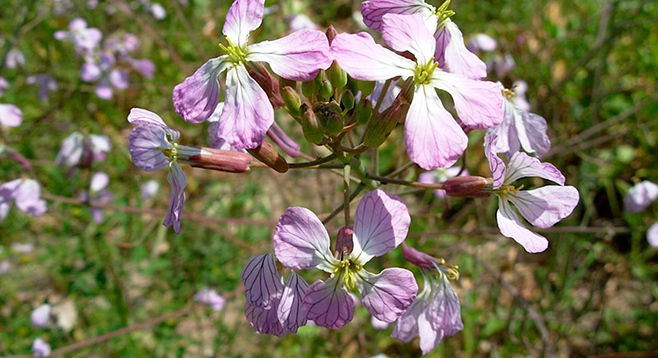
We have come about 0.3 mile. Another 0.1 mile leads to Juniper Street. Surrounding us are the tall eucalyptus trees from Australia and bushy acacia from South Africa. The trail goes over a rocky section and shortly after the canyon opens up with annual weeds. Some are attractive like the crown sunflower, mustard, and wild radish, found on the bottom, and various shrubs on the slopes. A very old wild-blackberry vine lies to the right of the steps and ramp leading up to the sidewalk.
Crossing Juniper Street from the sidewalk to the gate barring a segment of the service road involves climbing over the low fences on both sides of the street that are designed to keep swerving cars from going over the edge. This and the new sign showing drivers how fast they are going should be sufficient warning that cars tend to come down this hill faster than is safe and that caution must be taken to be extra alert while crossing the street.
After crossing the street and going around the gate, one is surrounded by coastal sage scrub. This is a community of shrubs, most of which drop their leaves in the hot, dry summer and look as dead as the annual weeds at the side of the trail. The shrubs near the start of the trail include toyon, with its year-round, holly-like leaves, and coastal sagebrush, which gives this plant community its name. It is not a true sage, but the fragrance of its gray-green, thread-like leaves smells like one. Going on, there are stands of flat-top buckwheat, whose flattened sprays of pinky-cream flowers are a major nectar source for a host of insects. In the summer when most of its small leaves are gone, the plant is still recognizable from the remains of the flower clusters, now gone to seed and a rusty color. When in bloom, the showy, yellow California sunflower will catch one’s attention. In addition, there are the grandly scented black (dark green leaves) and white (larger grayish-white leave) sages, laurel-leafed sumac with its taco-shaped leaves, and scrub oak.
At 0.2 mile, the trail narrows to a path and comes to an abrupt drop-off of about two and a half feet into the rocky “stream-bed” canyon drainage. To descend, there are a couple of steps cut into the bank on the right. The bottom consists of smooth stream cobbles, such as we have seen at other places on the trail. The reddish and purple ones are rhyolite, a silicon-rich lava. Scientists at San Diego’s Natural History Museum traced the origin of these rocks to a mountain in Sonora, Mexico, to the east of us and over 400 miles to the south! This was an important piece of evidence supporting the then-controversial theory of continental drift (plate tectonics). After about 50 feet in the streambed, the trail comes back out where there are now thick stands of a fuzzy, gray-green shrub. It is woolly yerba santa, Spanish for “sacred herb,” used by Native Americans and Spanish settlers in many medicinal preparations. At 0.28 mile, there is an easy crossing of the drainage, with tiny white-flowered, sweet alyssum, a garden escapee, taking advantage of the moisture and shade found under a bank. On the other side is a stand of mojave yucca, also called Spanish bayonets. In short order one comes to a black-walnut tree, unusual for our area, growing in the micro-climate created by the canyon drainage. Soon the trail comes to a more open area, full of ragweed and crown sunflower, bordered on the east by a stand of prickly-pear cactus and some acacia trees. Just past this open ground, at the edge of a grove of eucalyptus, is private property, so return on the same trail.
Distance from downtown San Diego: approximately 4 miles. Go north on First Avenue and take I-5 south, exiting on Pershing Drive. Continue north for about a mile before taking a slight right onto Redwood Street and continue on Redwood, turning south onto 32nd Street then east on Nutmeg Street. The trail is on the south side of Nutmeg Street between 33rd and Felton Street. | Hiking length: Round-trip distance is 1.6 miles with the trail cut in half by Juniper Street. It can also be walked as two separate hikes of less than a mile each. | Difficulty: Easy. Elevation gain/loss of 100 feet with uneven, rocky parts, and a spot in the south half of the trail where one has a brief scramble across the bottom drainage. No facilities.