Sponsored
Sponsored
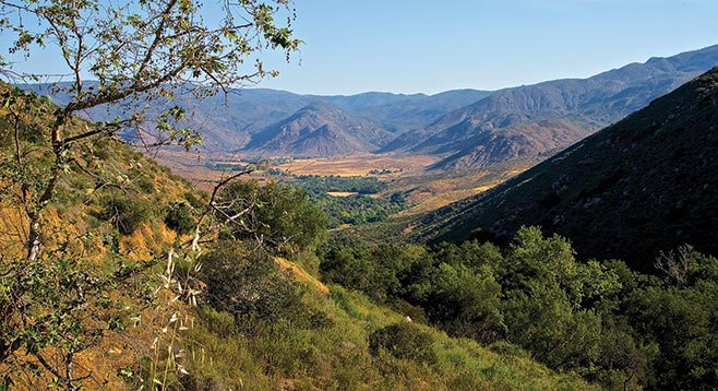
The Lower Santa Ysabel Trail, now reserved for hikers and equestrians, takes you beside a lush riparian forest of towering sycamores, willows cottonwoods, and spreading oaks, draped with native grape vines as it travels beside or above Santa Ysabel Creek, then climbs up into bordering patches of grassland and chaparral. Depending on the season and rainfall, you may find a colorful display of wildflowers.
From the parking area, begin hiking north on FS12S04 to Santa Ysabel Creek. FS12504 forks upon reaching the creek. The road to the right becomes the Orosco Ridge Truck Trail. The Lower Santa Ysabel Trail begins to the left. At this point, the trail is a dirt road and open to motorized vehicles, but there is a locked gate 0.25 mile from Pamo Road and only authorized vehicles can continue beyond the gate. The trail is an easy hike in and out of the shady forest for nearly 1 mile but then begins to climb up the side of the mountain, reaching an elevation about 200 feet above the creek. After coming to another locked gate 1.29 miles from Pamo Valley, the trail levels off and continues through mixed ceanothus chaparral until it reaches Boden Canyon, 2.25 miles further on. There are at least three ways to complete this hike:
Option 1 is an easy 4.7-mile out-and-back hike. Continue down the trail from the second locked gate to an unnamed tributary canyon leading to Santa Ysabel Creek, 2.35 miles from Pamo Valley. It is a heavily wooded tributary with a dense forest of grape-festooned coast live oaks, sycamores, and cottonwoods. A bubbling creek with seasonal running water runs through it, making it a cool, shady place for lunch or a picnic. Go back the way you came to complete this hike.
Option 2 is a moderate 5-mile point-to-point hike. Continue on to Boden Canyon, 3.4 miles from Pamo Valley. Go left, descending to a truck trail. Continue west on this dirt road for 1.6 miles, until you reach the turnout on Hwy 78. If you elect this option, you must pre-arrange to have someone pick you up on Hwy 78. Since parking is no longer permitted at this turn-out, you need to get the timing right to make this work.
Option 3 is a more strenuous 10.2-mile hike. The option takes you into the Boden Canyon Ecological Reserve. Upon reaching the Boden Canyon, instead of going west (left), turn right and go north. The dirt road crosses Santa Ysabel Creek and becomes a hiking trail, leading up a short hill and then through a delightful riparian wilderness. After hiking 1.8 miles through the reserve, another trail branches off to the right. This goes east and connects with another truck trail. This is a good place to turn around and go back the way you came for a moderately strenuous 10.2 out-and-back hike. Taking the trail up and over the Orosco Ridge is a slightly shorter way back to your car, but it involves an additional 1300 feet of elevation gain. It is also a hot hike up the ridge with no shade and possible danger from shooting on the ridge.
Note: Routes are checked from multiple sources where differences may occur. An example of this is Forest Road (FR) 12504 versus FS12S04. FS12S04 is correct and describes location: Forest Service (FS), Township (12) Section (S), and Road number (04). Boden Canyon, Drasco (misspelling of Orosco), and Guejito Truck Trails were labeled as “Truck Trails” due to map-source conflicts.