Sponsored
Sponsored
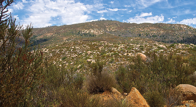
There are two Black Mountains in San Diego County. One is in Carmel Valley and the other is near Ramona. At an elevation of 4051 feet, the one near Ramona is by far the largest of the two. As the most prominent mountain in this remote area, it provides an excellent panoramic view of the surrounding wild territory. Additionally, its unusual geology makes it a good place to find rare plants.
The “trail” is a dirt road that often takes you through chaparral with little or no shade, making this a strenuous 14.2-mile out-and-back hike with about 3000 feet of elevation gain. However, it also can be an easy 2-mile stroll to the top of the mountain. Usually you can drive 12 of these 14 miles if you have a sturdy four-wheel drive vehicle. However, there are no facilities or drinking water regardless of how you do it.
If you elect to hike to the top, park at the junction of Pamo Valley Road and Forest Road 12S07 and start walking. This will give you a better chance to explore the area, perhaps to find and identify some of the rare plants and see some wildlife, in addition to providing you with a little exercise. Although the entire area was burned when the Witch Fire roared through here in 2007, the vegetation is recovering and there is a lot to see, particularly in the spring. Wildflowers often are more abundant and easier to locate a few years after a fire.
One and a half miles from the trailhead, Forest Road 12S07 meets the Black Mountain Truck Trail, or Forest Road 11S04, going off to the left. The gate here is usually open. As you continue up Forest Road 11S04, you pass near the Organ Valley Research Natural Area, 4.6 miles from Pamo Valley. This 500+ acre study area was set aside to learn more about Engelmann oaks, which are abundant here but relatively rare elsewhere. Black Mountain is so named because of the black or dark gabbro rocks that are found here. Several rare plants that can grow on gabbro–derived soil, including Orcutt’s brodiaea and Orcutt’s linanthus, may also be found here.
Continue on Forest Road 11S04 to within about a mile of the top of the mountain, where you will encounter another gate. This one will be locked. Park here and hike up the road to the right. It does not go all the way to the top, but you will find an improvised path for the last 0.2 mile to the top. There was a lookout tower on the peak until the 1970s. A solar-powered weather station now stands on the concrete foundation of the former fire lookout. After taking in the extraordinary view, which may extend out to the Pacific, return the way you came.