Sponsored
Sponsored
For those looking for something a little more challenging, the Dripping Springs Trail is perfect. The series of dramatic vistas stretch as far north as the San Bernardino Mountains. Most of the major southern California vegetation types are encountered while hiking through the Agua Tibia Wilderness.
Dripping Springs Trail begins among granite boulders in a seasonal stream lined with coast live oaks, sycamores, and willows at an elevation of 1600 feet. Initially, the route goes up a ridge covered with inland sage scrub and then through dense chaparral with white thorn ceanothus and manzanita thickets. Finally, the route leads to the Coulter pine, big-cone Douglas fir, and black oak–forested Agua Tibia Mountain at an elevation of 4400 feet. Agua Tibia Mountain is not a distinct peak but a broad ridge that is the northern most high point in the Palomar Mountain range.
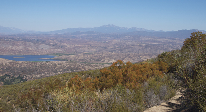
The Dripping Springs trailhead is at the far end of the Dripping Springs Campground, about half a mile from the campground entrance. Proceed south along the dry Arroyo Seco Creek bed for a short distance after leaving the campground before entering the wilderness area. A tenth of a mile from the trailhead, there is a junction with the Wild Horse Trail on the left. The Wild Horse Trail continues up the Arroyo Seco and is another way to reach the summit, but it is not easily navigated. The Dripping Springs Trail soon leaves the creek and begins a series of switchbacks up the dry side of the canyon onto a broad ridge. During the first mile, the trail passes through typical coastal sage scrub with abundant California sagebrush, black sage, buckwheat, mission manzanita, and yerba santa. Many of these will be in bloom in season, with the addition of golden yarrow, honeysuckle, bush penstemon, and blue aster. In a short distance, a panoramic view opens up to include vineyards and Vale Lake below, along SR-79, with Mt. San Jacinto and Mt. Gorgonio in the distance to the north. Further along the trail, which increases in elevation, typical chaparral species begin to appear, including white thorn ceanothus, tall ribbonwood up to 15 feet in height or more, and big berry manzanita. Other plants that may be in flower include yellow bush current, woolly blue curls, chaparral yucca, yellow bush poppy, purple nightshade, penstemon, peony, wild cucumber, and mariposa lilies.
The Dripping Springs Trail ends on the shoulder of Agua Tibia Mountain, where it intersects with the Magee–Palomar Trail, 6.9 miles from the trailhead, in a beautiful grove of big-cone Douglas firs, Coulter pines, and coast live oaks. It is a place where hikers frequently camp. If considering this for an overnight backpack trip, plan on a dry camp and pack plenty of water. There are no springs on the Dripping Springs Trail; in fact, the campground and trail are named for springs that lie on the other side of SR-79. Also remember that no campfires are permitted. If not camping, retrace your steps back down to the campground and your vehicle.
Check on permits needed for access to Agua Tibia and Pine Creek, the two National Wilderness Preservation System areas in the San Diego portion of the Cleveland National Forest.
Distance from downtown San Diego: About 45 miles. Take I-15 north to Temecula and exit at SR-79 east. Drive east 10 miles toward Vale Lake and look for the Dripping Springs Campground sign on the right. Park in the day-use parking lot. There is a $5/vehicle charge, and a Forest Service Adventure Pass is required.
Hiking length: 13.8 miles out and back.
Difficulty: Strenuous with about 3000 feet of elevation gain/loss. There are no sources of drinking water once you leave the trailhead. Carry plenty of water. The trail is well constructed, signed, and maintained. If backpacking overnight, a wilderness permit is needed and no campfires are allowed.