Sponsored
Sponsored
Poway Creek Trail is number 27 of the 30 trails listed in the Poway Trails and Open Space System guide. The trail is just north of Poway Creek with numerous native riparian plants plus non-natives that grow along the mostly shaded trail. The initial path from Midland Road transitions from concrete to decomposed granitic soil as you walk behind the shopping center. It passes by a small amphitheater and ends at Community Road.
There are a number of different types of pine trees along this section, plus native cattails growing in the creek for the entire distance of this walk.
Listen for the one-second call of the male red-winged blackbirds. Look for a dark black bird with scarlet and yellow shoulder patches found mostly on high perches with the females found at the lower elevations camouflaged by their dark brown streaked bodies that are a lighter brown on the breast. The females may have a whitish eyebrow.
Turn right (north) to the corner of Community Road and Civic Center Drive and cross at the signal, then go south on Community Road, past the fire station before turning right to continue on the Poway Creek Trail going west.
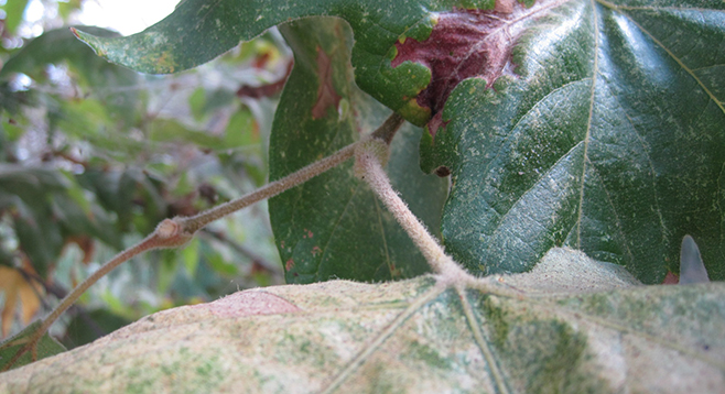
Notice the sycamore trees (Platanus racemosa) with their large palmate leaves surrounding the new buds with the base of the stalk. The fruit is a ball-shaped head hanging on a pendant. Other riparian plants seen in the area are western cottonwood and willow. Just before Bowron Road is a bridge that crosses over the creek to the Poway Royal Estates. Walk to the center of the bridge for a view of the creek through the plants before returning to Poway Creek Trail to continue west (left).
Pass by the Boys & Girls Club building and a softball field to a rocky section that spans Poway Creek. In this area, there is the low-growing Himalayan blackberry, an invasive plant well armed with thorns and prickles. There is also marsh fleabane, a native herb growing erect with a large cluster of pinkish-purple or magenta flower heads.
Return to the trail and continue west (left) past the dog park that is divided into small-, medium-, and large-breed areas. At the Y-intersection, continue left to another bridge where you can turn around after viewing the creek and the merge of Rattlesnake Creek into Poway Creek, or cross the bridge to the end of the trail at Soule Street before turning back to your vehicle.
Options are to turn north at the Y-intersection to view Rattlesnake Creek for a short distance to another bridge that crosses to Buckley Street, or walk on a combination of sidewalks and parking lots to the end of this section of the creek just north of Poway Skate Park and Civic Center Road. Alternatively, continue west on Soule Street to another bridge crossing to the Carriage/Oak Knoll Road intersection.
Distance from downtown San Diego: 22 miles (Poway). Allow 30 minutes driving time. From Highway 163N, merge onto I-15N then take exit 18 Poway Road. Turn right (east) at the signal. Continue on Poway Road for 4.1 miles, then turn right (south) onto Midland Road for a short distance. The path starts at the southeast corner of the shopping-center parking lot at 13066 Midland Road.
Hiking length: Approximately 1.85 miles out and back.
Difficulty: Easy, with less than 100 feet of elevation gain/loss. Horses are allowed on the urban trail along Poway Creek behind City Hall and Creekside Plaza. Bicycles and dogs on leashes allowed from Midland Road to destination. Open sunrise to sunset.