Sponsored
Sponsored
There are many reasons to stop and explore the Inaja Picnic Area. First, it is a great place for a picnic, with tables under shady ramadas or old coast live oaks. Additionally, a nature trail, one of the few National Scenic Trails in the San Diego area, circles the hill behind the picnic area and provides great views down into the rugged San Diego River Canyon to the southeast, a contrast to the pastoral view of the Santa Ysabel Valley off to the southwest. Finally, this is a great place to learn about the transition zone where chaparral gives way to forest.
At the site is a memorial to 11 firefighters who died here on November 25, 1956, when the wildfire they were combating suddenly turned and shot upcanyon before they could escape. It is recorded as one of the worst firefighting disasters in the nation. The tragedy changed forever how wildfires are fought in America. The deaths of the firefighters — three trained Forest Service firefighters, seven Viejas Honor Camp volunteers, and their correctional officer — led to a new determination to understand wildfires and to develop new rules for engagement: the 1957 original ten Standard Firefighting Orders.
The hiking trail begins on the west side of the restroom and extends in a loop up to the high point on the ridge before returning to the picnic area. In the past it was a nature trail, with numbered stops and a brochure providing information on some plant or feature at each stop, but most of the numbered posts have disappeared and brochures are no longer provided.
Although the trail starts out in oak woodland, it soon takes you out onto a southwest-facing hillside covered with vigorous chaparral. The principal shrubs found here include two kinds of ceanothus, big-berry manzanita, mountain mahogany, scrub oaks, and chamise. In the spring, wild hyacinths and winter currents provide colorful accents while blooming ceanothus scents the air with a wonderful aroma. The trail also passes massive granite boulders that have been eroded into dramatic shapes.
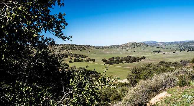
Several viewpoints are found off the main trail. One near the halfway point looks down into the rugged San Diego River Canyon. The dense vegetation carpeting these steep canyon walls is testimony to the ability of the chaparral to regenerate, if it does not burn too hot or frequently, as was the case in the 1956 Inaja Fire and in the 2003 Cedar Fire. Another viewpoint looks northwest to pastoral Santa Ysabel Valley where black cattle graze in verdant grasslands dotted with scattered live oaks. The elevation at the overlook at the top is 3440 feet.
Completing the loop returns you to the parking area and also an inner loop to explore before leaving.
Distance from downtown San Diego: About 58 miles. Allow 1 hour and 25 minutes (Santa Ysabel). From Ramona, drive east toward Julian on SR-78 to Santa Ysabel and continue approximately 2 miles further, heading up the hill. Look for the Forest Service sign for the Inaja Picnic Area on your right, just before the road curve, and exit there and park. CNF Adventure Pass required.
Hiking length: Up to 1 mile. Allow up to 1 hour.
Difficulty: Easy. Elevation gain/loss less than 100 feet. Facilities. No water. Dogs (on leashes) allowed. The best time to visit is in the spring, but it can be enjoyed year-round.