Sponsored
Sponsored
Spring is the optimal time to visit Airplane Monument. Chaparral and coastal sage scrub brighten the landscape with an array of beautiful flowering plants, such as chaparral white thorn and white sage. Checker blooms and golden yarrow are prevalent wildflowers during spring, which are another aesthetic feature on your walk. Majestic granitic rocks dot the landscape with aggregate chunks of white and black, making it a fairly difficult landscape to navigate in remote spots on the trail.
The trek to Airplane Monument begins on the north side of SR-79, immediately after crossing Sweetwater Bridge. Go north, then left to the southwest, paralleling SR-79 on the West Mesa Trail in a beautiful oak-forested area of the Cuyamaca Rancho State Park. Just short of a half-mile into the hike, turn right to take the Monument Trail. Summers snow, or Linanthus, decorate the walk with beautiful white flowers. Be sure to listen for Steller’s jays, scrub jays, and acorn woodpeckers. Birds such as the black-headed grossbeak and lazuli bunting have also been observed on this hike. As you ascend, the scenery changes from an oak woodland to a dense chaparral with patches of coastal sage scrub. Evergreen shrubs become the dominant scenery.
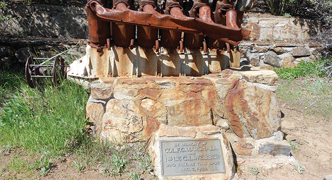
After a winding 2.5 miles through various habitats, you reach the hike destination, Airplane Monument. The 1000 feet of elevation gain provides a panoramic view of the surrounding Cuyamaca Rancho State Park. Be certain to bring binoculars so you can see the geologic beauty of Stonewall Peak from the monument. The monument is a Liberty 12-cylinder aircraft engine mounted on stones. The engine is from a DH-4B biplane that crashed on December 7, 1922. An Army pilot, First Lt. Charles Webber, volunteered to fly Col. Francis Marshall to Arizona from San Diego to conduct official military business in Fort Huachuca. Due to inclement weather, Webber turned back to San Diego. Shortly after reversing his course, the plane experienced engine trouble, and without a radio to communicate their engine failure, Webber and Marshall crashed into the ridge below Japacha Peak. Neither Webber nor Marshall survived. Search-and-rescue teams failed to recover the men and their plane after months of searching. Five months later, a local rancher by the name of George McCain found the burned remains along with the airplane wreckage. The engine block of the DH-4B biplane was mounted as a memorial for the World War I veterans. Beware of bees that have taken residence inside the engine.
You can either return by the same trails or extend 0.5 mile as a loop by continuing north from the engine where the Monument Trail continues as the West Mesa Loop Fire Road. Turn south on Japacha Fire Road (or Pipeline, depending on the reference map used) after crossing Japacha Creek, continuing south on West Side Trail. Just north of the Sweetwater Bridge, turn left to cross SR-79 to the parking lot. Note that trails may have multiple names as they merge (i.e., Japacha and Pipeline Fire Road). Neither route is recommended to hike in winter. However, the trail is well defined and can be navigated by advanced hikers when snow covered.