Sponsored
Sponsored
This part of Encinitas is dominated by a dissected sandstone plateau, with an elevation of up to about 250 feet above sea level. A golf course and many large homes have been built on the plateau, most with dramatic ocean views and elaborate, non-native landscaping. However, several of the canyons have retained significant native habitat. Either they were too steep to build on, or they have been preserved as open space. The Quail Hollow and Indian Head trails traverse one of these open spaces and retain an amazing diversity of native plants and animals.
Begin your journey from the Quail Hollow trailhead by heading southwest on the broad, sandy, Indian Head (IH) Trail #1. The sandy trail continues for about 0.2 mile as it gradually bends south and continues toward a thicket of trees and riparian habitat. As you grow closer to the grove of trees, you find that they are mostly tall, rather large eucalyptus with an understory of unusually large, vigorous toyons, especially on your right. The vegetation on the left includes an abundance of tall broom baccharis and lemonadeberry. The trail at this point is near an intermittent stream, which probably accounts for the vigor of these trees and shrubs, though the species composition is unusual for riparian habitat.
At 0.3 mile the trail emerges from the forest and begins to rise as it turns gradually toward the east. Although not marked, IH Trail #1 merges with IH Trail #2 and continues east, entering a degraded grassland, with an abundance of non-native annual grasses, including wild oats and foxtail brome, as well as black mustard.
At about 0.4 mile, the trail appears to fork. Keep left for the main IH #2 trail, now demarcated with a rail fence on your left. The trail continues to ascend the hill as its direction gradually bends toward the north, re-entering habitat that seems to be an intermixture of southern maritime chaparral and coastal sage scrub species.
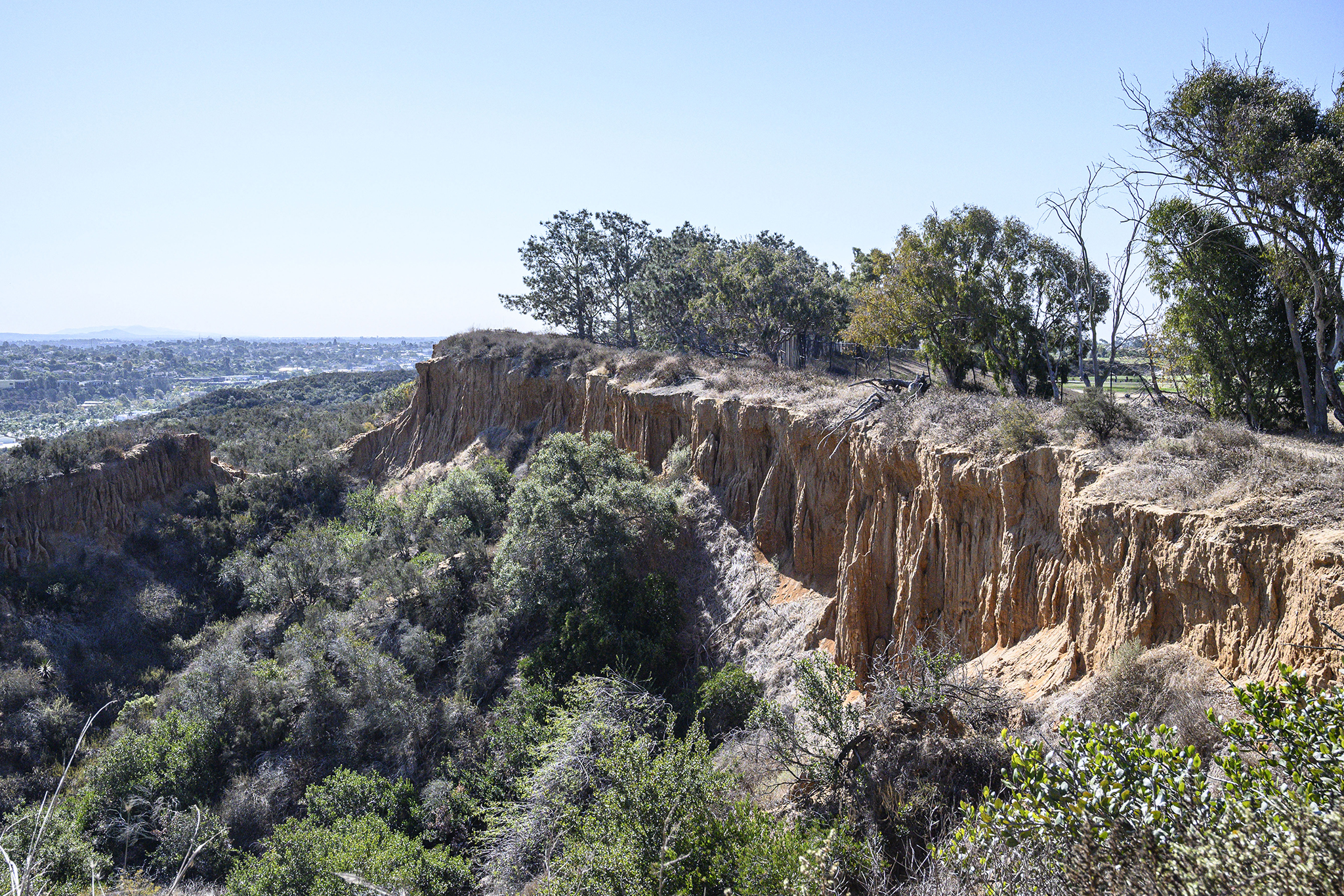
At 0.65 mile you reach the top of the hill, giving you an inspiring view of the surrounding terrain and out to the ocean. From here you have a choice. A sign on a chain link fence informs you that you can’t go east, as you would be entering private property and subject to arrest. Although the sign instructs you to take the trail to your left — which follows the fence and, in a short distance, begins to go straight down a rather steep slope — take the trail to the right instead.
The trail to the right is not only safer but also takes you through more interesting habitat that includes a few Del Mar manzanitas, fuchsia-flowered gooseberry shrubs, coastal golden bush, and Mojave yuccas, as well as lemonadeberry, California sagebrush, broom baccharis, spine shrub, black sage, and other common residents of coastal sage scrub. Additionally, it gives you a view northeast into the Magdalena Ecke Open Space Preserve, to which the public has no access.
If you take this trail to the right after reaching the hilltop, you will be back on IH #2 after hiking an additional 0.35 mile. Continuing a short distance west on trail #2, you will see less traveled trail, initially parallel with trail #2 and also going west. You may consider this as an alternative way back to the trailhead, though it mainly stays in degraded grassland and is a little rough in spots. Russian thistles, black mustard, and star thistles are the dominant plants immediately beside the trail, though these invaders are less common where they must compete with the annual grasses. Farther along the trail, you also must divert around some large acacia bushes that have overgrown the trail.
Once off the hillside, a trail proceeds north, up a canyon. Though not signed here, it could be called Quail Hollow Canyon, as it is home to an abundance of California quail. Be prepared for the explosive sound of dozens of quail suddenly taking off from the adjacent brush as you walk by. If you want to see them before they fly, find a shady spot, sit, and just listen for their calls.
You reach Quail Gardens Drive at 0.7 mile from the Quail Hollow trailhead. The trail continues on the other side of the road on a narrow pedestrian path that crosses a neck of the Encinitas Golf Course and proceeds up the hill to a large water tank on the ridge high point. This water tank trail continues east as it skirts near the edge of a sandstone cliff, proceeding east toward Leucadia Boulevard. As it nears Leucadia Boulevard, it bends south, continuing down a trail parallel to the highway until you reach a pedestrian bridge crossing the highway, 1.2 miles from the Quail Hollow Trailhead.
At this point, you must make another choice – either to go back the way you came or elect to continue on, going south on the Leucadia pedestrian trail to Sidonia Street. Cross Leucadia at the signal and walk 0.3 mile down Sidonia to its end where Indian Head Trail #1 begins. Follow it back to the Quail Hollow trailhead. The distance is about the same either way, but the Sidonia route is nearly all downhill (226 feet elevation loss).
If you have time, you should explore another nearby trail with spectacular views, namely, the Encinitas Swallowtail Trail. Go north on Quail Hollow Road to Swallowtail Road, make a left and continue to its end, 0.6 mile from the Quail Hollow trailhead. The Swallowtail Trail goes down a narrow ridge between two of the canyons dissecting the mesa. The habitat is coastal sage scrub. It is a short hike, 0.33 mile down to a fence blocking further progress, but from there you find yourself just above La Costa Farms, a small village overlooking Batiquitos Lagoon and the ocean to the west.
QUAIL HOLLOW & INDIAN HEAD TRAILS, ENCINITAS
Discover native habitat in these open space areas