San Carlos in 1960 was a series of tract homes out in the boonies. There were plenty of hills, trails, and wilderness for a young boy to run wild. My family lived on Lake Aral Drive, a neatly arranged street with brand new lawns and trees. I was five years old and beginning to make friends with the other kids my age. It seemed like every house had a couple of sons and daughters right around the same age group. It was a ready-made gang. You might recognize the names of some of the kids in San Carlos at that time. Danny Alsadt, David Allen Lucas, Brenda Spencer.
By Mark Stephen Clifton, Oct. 22, 1992
Our local heroes were also dropping like flies. For many, many of our childhood friends in San Carlos, the drug culture was consuming them too.
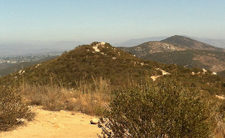
Drive out to the main Cowles Mountain trailhead, which lies at the northeast corner of Navajo Road and Golfcrest Drive in the San Carlos district of San Diego. The zigzagging trail ahead is popular with hikers and dog-walkers, but no mountain bikes are allowed on it. Climb steadily for 1.4 miles to the top of Cowles, then set your sights on Pyles,
The City of San Diego's plan to demolish and replace a pump station that has served San Carlos since 1967 received unanimous approval from Navajo Community Planners, Inc. on February 25. The estimated $7.5 million budget covers the planning, design, and construction of a replacement for the College Ranch Hydro Pump Station. The facility and a 102-foot tall standpipe (water tank), located between two houses on Lake Ashmere Drive.
San Carlos Navajo Community Planners, Inc. (NCPI) on March 18 voted 8-1 to take an alternate method of requesting a four-way stop at Cowles Mountain Boulevard and Boulder Lake Avenue, a San Carlos intersection that was the site of vehicular accidents on January 12 and February 15 of this year. The intersection didn't meet the city-council criteria for "all-way" signage.
The planning group unanimously approved the installation of a four-way stop at Green Gables Avenue and Wandermere Drive, and a board majority rejected a proposal to return a portion of Jackson Drive to two lanes. Also, a majority opposed the City of San Diego's plan to raise the speed limit from 35 to 40 miles per hour on a stretch of Navajo Road.
By Liz Swain, Oct. 24, 2013
Intersection of Jackson Drive and Cowles Mountain Boulevard
Ryley Webb, San Carlos liaison for District 7 city councilman Scott Sherman's office, gave the planning group an overview of efforts to resolve the matter. At the September 16, 2013, Navajo Planners meeting, residents living near Cowles Mountain said hikers were noisy and left behind trash. Residents supported a proposal to add 19 parking spaces on Navajo Road. Planners rejected that proposal, citing safety concerns on the street where the speed limit is 50 miles per hour.
Stefanie Sekich has dealt with drones near her home in San Carlos on three occasions. The first time, she was outside enjoying a glass of wine and didn’t think much of it. She thought it was probably some neighborhood kids with a new toy. The second time occurred on a Friday night. She had her headphones on and was listening to music. The buzzing approach was inaudible, and she didn’t realize the drone was present until she noticed it above her. When she made eye contact with the drone it zipped away.