Sponsored
Sponsored
The Coyote Mountains are part of a larger area known as the Colorado region of the Sonoran Desert. Here two plates meet, the Pacific Plate to the west and the North American Plate to the east. Molten rock, rising from deep under the earth’s crust is pushing these plates apart. It is this spreading that caused the formation of the Gulf of California as ocean waters spilled into the subsiding rift valley. About 7 million years ago (MYA) the Gulf extended as far north as San Gorgonio Pass in Riverside County. These warm and shallow waters supported a variety of marine life, traces of which are found here today. Look for, but leave in place, the fossils of sand dollars, oysters, sea biscuits, conch shells, scallops (pectens) and tube worms.
Beginning about 5 MYA the ancestral Colorado River began to deposit massive quantities of sediment into what was then the head of the Gulf. These sediments were the byproduct of this major river cutting its way down through the Colorado Plateau of Arizona and producing features such as the Grand Canyon. The deposits of sand and clay were thousands of meters thick, eventually pushing the head of the Gulf further south. This retreat left behind the sculpted sandstone and mudstone formations seen today, including mud caves, some large enough for a person to sleep in.
The landscape, sparsely dotted with ocotillo and creosote, supports some unique plants including the malevolent looking devil’s spine flower, desert holly, rush milkweed, and showy cotton-top or Mojave mound cactus. Look for the large reddish-topped hedgehog clusters of cactus with bright yellow flowers and barrel cactus-like spines near the wind caves.
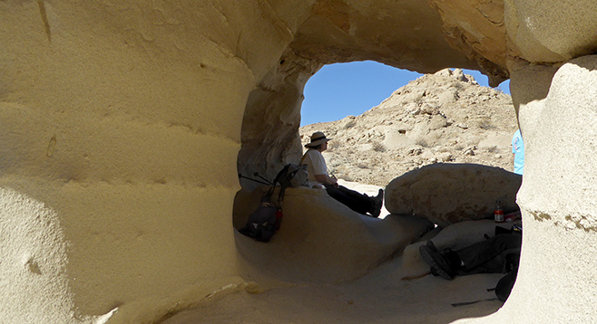
With a steep climb up a mud hill, this hike into the BLM’s Coyote Mountains Wilderness gets your heart pumping from the start. For the first mile plus, the route follows a deeply-eroded jeep road. After that, the trail can be difficult to find, so use your GPS and map. Where the first wash enters the main wash, stay left. Upon reaching a second wash, turn into the drainage and follow it to the end. Now look to your left and climb the clear path up the incline to the well-defined route along the slope. You will start noticing shells in the rocky terrain. There are two small canyons to cross, and then the trail turns up the mountain at a very steep pitch. Reaching the top is worth the climb. The views of the Carrizo Badlands and Salton Sea from the “castle rock” wind caves are sweeping.
The trail continues southeast around the ridge to another dome-shaped wind cave. Here you can relax in the shaded hollow of an ancient sand dune, weathered by wind and water and sculpted into rounded formations and sheltering caves.
After exploring the area around the wind caves, the easiest way to return is back the way you came (beware, the trail is just as difficult to follow on the way out). Or follow a more difficult trail down into a slot canyon and up a wash to complete a longer loop back to the parking area.
Driving Directions: Drive east on I-8 into Imperial County and exit at Ocotillo. Turn left, passing under the freeway, and drive through the townsite of Ocotillo, following S-2 for 7.2 miles to BLM dirt road 093 on the right (east). Look for the informational kiosk and parking area. If you pass the border patrol checkpoint on S-2, you’ve gone too far. High clearance or 4-wheel drive vehicle is needed. Follow the dirt road toward the mountains for 2 miles to its dead-end parking area, designated by posts and chains. NOTE: Some use this BLM land as a shooting range, mostly around the parking areas.
Hiking Length: 6 miles. Allow 5 hours for this hike. The trail is not marked or maintained and user-made trails readily branch from the main route. GPS and a good map and compass are advisable. The trail is open to mountain bikers and hikers.
Difficulty: Moderately strenuous. Elevation gain about 1000 feet with steep climbs and deep canyons. No facilities, no water, and no shade. Not recommended for dogs, even though pets are not excluded from the area. Start early in the morning and bring plenty of water for this exposed desert hike. Best to visit during winter months. Exposure makes this area hotter than many other areas. In winter, the temperature can still register 90 degrees.