Sponsored
Sponsored
The Crossings at Carlsbad Golf Course was designed by Greg Nash with the preservation of habitat and the city’s trail system being an important consideration in creating a challenging course. The holes for this city-owned golf course are tucked into diverse ridges and flats within the rugged Macario Creek Canyon, creating an unusual juxtaposition of lush green lawns separated by native coastal sage scrub or the riparian corridor of Macario Creek itself. The greens are connected by 7 miles of paved trail on which golfers use carts to reach each hole. Note: only the Crossings Trail section of the golf course is open to hikers.
The Crossings Trail section of the paved golf course trail is an official City of Carlsbad hiking trail and connects a tributary canyon with coastal sage scrub habitat on the northwest side of the golf course with the undeveloped Veterans Park on the other side of Faraday Drive.
From the trailhead, hike down a dirt road on the east-facing slope of this tributary canyon. You are likely to create a flurry of activity in the vegetation along the canyon bottom as flocks of California quail are flushed from their shrub cover.
In about a third of a mile the well-marked trail makes a hairpin turn and proceeds parallel to the Macario Creek bed. This part of the trail takes you through a transition zone between coastal sage scrub and riparian habitat, with mulefat and arroyo willows competing with coyote baccharis, California sagebrush, black sage, laurel sumac, sugar bush, and other typical coastal sage scrub species.
Macario Creek only has flowing water after rain storms, when its waters empty into the Agua Hedionda Lagoon. In addition to frequent trail-markers, you will also see occasional signs for the Agua Hedionda Lagoon Discovery Center. You cannot reach the Discovery Center via these trails unless you continue on the sidewalk bordering Faraday Road (for some reason the City of Carlsbad counts sidewalks as part of its “trails”). The Discovery Center is well worth a visit, but don’t be misled by these signs.
In about another third of a mile the dirt trail joins the paved golf-course trail. Follow it to the left, crossing the dense growth of black and arroyo willows, California sycamores, and some coastal live oaks. The trail is partly on a bridge about 12 feet above the creek wetlands and leads to one of the golf-course greens. Shortly after reaching hole #12 on your left, you will see a tunnel on your right that goes under Faraday Road and leads to the Veterans Park trail.
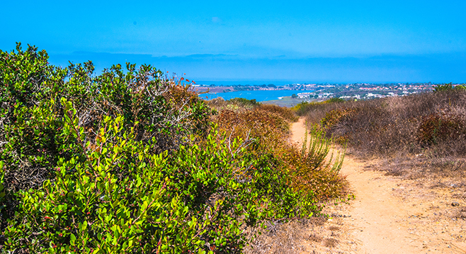
After passing through the tunnel, you have two choices: you may take the trail to the east (right), leading up to an excellent spot for views of the golf course; or the west (left) trail, which will take you to a place providing excellent views of the lagoon and, on a clear day, out to the ocean beyond. Until recently these two trails were connected, forming a loop, which made for an appealing hike. However, the piece of land containing the connecting trail is not part of the city property set aside for the future Veterans Park. So, avoid the section comprising the loop and treat both the left and right trails as separate out-and-back segments of this hike.
The lower slopes of Veterans Park may once have been open grassland, perhaps used to graze domesticated animals. In recent years, the land has been mowed regularly in summer and may be almost denuded of vegetation at the time of your hike. The upper slopes of both the east and west trail branches are covered with coastal sage scrub.
When you have completed your exploration of Veterans Park trails, return to your vehicle the way you came.
Driving Directions: From I-5, exit at Palomar Airport Road and drive east 1.3 miles to the Crossings Drive. Make a left and continue up the hill to the Crossings at Carlsbad Golf Course, on your right. The parking spots at the most northwest end of the Crossings lot are available for trail hikers and other visitors. The well-marked trailhead is up a dirt road about 50 yards west. Hiking length: 2.5 miles out and back. Allow 1.5 hours.
Difficulty: Easy. Elevation gain/loss 400 feet. Leashed dogs and bicycles allowed. Construction will continue near the trailhead for several months, but the trail is open.