Sponsored
Sponsored
Poway is a “city of trails” with some of the most popular hiking trails in coastal San Diego, especially those to Iron Mountain and Mt. Woodson. However, it has many other trails, mostly used by locals, some of which deserve to be known and used more widely. The hike described here guides you on two of these lesser-known Poway trails. They pass near and through native vegetation as well as semi-rural housing, offering outstanding views of natural and developed resources, including neighboring mountains and lakes. Hikers, runners, mountain bikers, equestrians and dog walkers (who keep their pet on a leash and pick up after them) are welcome to use these two connecting trails. However, there are no public facilities or sources of drinking water on or near these trails, so be sure to bring plenty of water. The area may be hot in August and September, though during the best months for this hike, March through June, there is usually a cooling ocean breeze. Most of the route is an easy walk on well-maintained, nearly flat, dirt paths, though there are occasional small hills to negotiate.
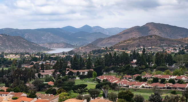
Begin the hike with a short, moderately steep climb from the Montero Road West Ridge Trailhead. After a brief climb, the trail levels off as it goes west through maritime chaparral, then turns north to follow the ridge, with views off to Lake Hodges and the mountains that surround it. During the prime spring months, the vegetation on either side of the trail contains an abundance of blooming chaparral species, including yellow bush poppy, red and orange flowered bush monkeyflower, white-flowered black and white sages, California buckwheat, and tall bee plants with tiny red flowers. A large golf course comes into view to the north, though it is far enough away for the houses lining the bright green fairways to look like LEGO blocks.
From the chaparral and boulder-covered crest, the trail gradually descends the ridge and proceeds north behind some large homes that now occupy the ridgetop. The most common native plants along this part of the trail are the occasional coast prickly pear cactus, blue elderberry trees, and clumps of laurel sumac and sugar bush. You also will find an abundance of non-natives, ranging from small, purple-flowered filaree, blue-flowered sea lavender, large clumps of Indian fig cactus, hedges of white-flowered myoporum, and even larger eucalyptus trees.
After walking about 0.5 mile, the trail makes a sharp turn east and continues straight ahead for another quarter of a mile. There is another nearly 90-degree turn here and the trail continues north until it parallels Vista Verde Road, then crosses a small citrus grove. The West Ridge Trail ends where Old Winery Road and Vista Verde Road intersect. The Lomas Verde Trailhead begins just across from the end of the West Ridge Trail.
Continue north on the Lomas Verde Trail for another 0.2 mile where it makes a sharp right-angle turn and continues due east up and down some hills for another 0.35 mile. The Poway City-maintained trail ends at this point. A well-trod use trail continues down the hill from the end of the Lomas Verde Trail to Sycamore Creek, which you can clearly see, and beyond to Old Coach Road. Enticing though it may be, it is better to stop your hike here, turn around, and go back the way you came, unless you are certain you are not trespassing on private land or already have permission to do so.
Directions: (Poway) From I-15, take exit 24, Rancho Bernardo Road. Go 2 miles east on Rancho Bernardo Road before making a left turn onto Pomerado Road. Continue north on Pomerado Road to Grandee Place. Turn right on Grandee Place, then left at its first intersection, Montero Road. Continue on Montero Road to its end, a cul-de-sac near Chaparral Elementary School. Park at the curb on Montero Road before reaching the cul-de-sac and walk to the West Ridge Trailhead, on the north side of the cul-de-sac. There is no parking in the cul-de-sac.
Hiking length: 3.5 miles out-and-back. Allow 2 hours hiking time.
Difficulty: Easy. Elevation gain/loss 420 feet. Leashed dogs, bicycles, and horses allowed. No facilities.