Sponsored
Sponsored
For those looking for stair stepping exercise in San Diego County, there are actually several options for a cardio workout: The San Diego Convention Center has about 100 steps; the “Catwalks” of Rolando Village are 8 neighborhood paths with various stairs and pathways; the amphitheater on Mt. Helix has concrete steps; Swami’s Beach and Torrey Pines State Natural Reserve have steps leading to the beach; South Fortuna Mountain in Mission Trails Regional Park has some challenging steps up to the summit; and Cabrillo National Monument offers steps below the lighthouse. However, one of the most delightful series of steps is found in La Mesa and is known as the Secret Stairs, with a total of 489 steps in seven segments. La Mesa is one of the few areas in the county that offers a system of public stairways.
Sections of the public stair trails of La Mesa’s Mount Nebo were originally constructed over 100 years ago to provide easy foot traffic to the neighborhood. The first two sections (44 and 16 steps) between Fairview Avenue and Vista Drive were constructed about 1912 or 1913.
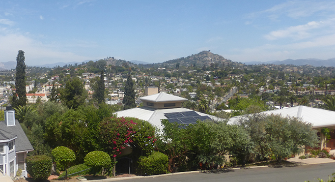
James Newland, a La Mesa author and historian, said that the other sections were constructed about 1927 as part of the Windsor Hills subdivision on Mount Nebo. At one time, this area “was considered a high-end suburban development, competing with similar developments in Talmadge and Kensington,” according to Newland. Mt. Nebo, with a summit elevation of 820 feet, offered unobstructed views of downtown San Diego, the Pacific Ocean, La Jolla, Mt. Helix, and the mountains to the east.
The largest segment is that between the intersection of Windsor Drive and Canterbury Drive to Summit Drive, which has a total of 245 steps in three sections, interrupted by two cross streets. Summit Drive at the top of Mt. Nebo has a cul-de-sac surrounded by houses that all have fantastic views of the surrounding area. The last segment of 184 steps has two sections between Summit Drive and Beverly Drive interrupted by a cross street.
A recommended route to do all 489 steps is a cherry stem beginning from La Mesa Boulevard across from La Mesa Springs Shopping Center, where there is convenient parking. Starting from the stop sign at the southwest corner of Acacia Avenue and La Mesa Boulevard, walk up Acacia Avenue and turn right on Lemon Avenue and then left on Alta Lane where you will encounter the first series of steps at Fairview Avenue. Cross Pasadena Avenue to complete this segment at Vista Drive. Cross Vista Drive to Sheldon Drive.
At this point you can take the loop in either direction, but if you’re looking for the most up-hill steps, take the loop to the left on Pasadena Drive to encounter the 245 steps up to Summit Drive from the intersection of Windsor Drive and Canterbury Drive. This segment crosses Sheldon Drive and Summit Drive and then ends at Summit Drive again when this winding street arrives at the top of Mt. Nebo.
Follow the curve of Summit Drive down to the next segment of steps that will cross Valle Drive and end at Beverly Drive. At Beverly Drive, turn left and follow the street until it merges with Sheldon Drive to complete the loop. Now follow the cherry stem back down the first segment to repeat the 60 steps to Pasadena Avenue and Fairview Avenue and the intersection with Alta Lane. Follow Alta Lane and turn right on Lemon Avenue and then left on Acacia Avenue to complete the trek. Because you repeated the first segment of 60 steps to return to the start, the actual number of stairs completed is 549!
Since this is an urban trek within a close neighborhood, be respectful of residents whose homes are next to the stairs and refrain from excessive noise. You may be hard pressed to find native plants along this trek. Largely, you will be encountering a variety of planted cultivars ranging from cacti and succulents to bougainvillea, varieties of flowering ice plant, and nasturtiums. The colors in spring can be stunning along this walk.
Driving directions: (La Mesa) Take I-8E to exit 13A, Spring Street toward downtown La Mesa, staying to the right at the road fork. Continue on Spring Street for 0.3 mile and turn right on La Mesa Blvd. Drive 0.3 mile on La Mesa Blvd., passing Acacia Avenue, and turn right after 0.3 mile into the La Mesa Springs Shopping Center at Normal Avenue and park. Walk back to Acacia Avenue, cross the street, and start the walk beginning at the stop sign.
Hiking length: 1.1 miles. Allow 20-30 minutes to complete a cherry-stem loop.
Difficulty: Moderate to Difficult (because of the steps). Dogs on leashes allowed on city streets. Facilities in La Mesa Springs Shopping Center.