Sponsored
Sponsored
Tucked into the foothills of Otay Mountain, this unassuming peaklet provides a quick getaway if you have just a couple of hours but want to escape the crowds and enjoy views of mountains near and far. As part of the Bureau of Land Management’s Sycamore Canyon recreation area, Donohoe Mountain is surrounded by a multitude of trails, providing the hiker with options for extending the trip described below if a longer walk is desired.
From the parking area, walk around the gate and pause a moment to read the sign describing the rules and regulations, as well as information about the endangered Quino checkerspot butterfly that lives in this habitat. Follow the dirt road west and then southwest, and in about 0.3 mile pass another road on the right. Continue straight, noting the prominent hill in the foreground to the right of the road. This is Donohoe Mountain, and your route to the top will be via the southeast ridge. Pass through a second gate and in 0.5 mile when at the base of the peak, leave the road and start climbing in a northwesterly direction up the slope.
A few wildlife trails traverse the hill, which can be followed for short distances but ultimately fade out, so just pick the best way up through the brush. Along the way you’ll encounter several familiar chaparral plants common to lower elevations, including laurel sumac, a large shrub with long, folded leaves and adorned with cream-colored flowers resembling miniature trees. Another abundant plant is flat-top buckwheat, a rounded shrub with dense clusters of white flowers that turn a distinctive rust color by fall and remain on the plant much of the year. The flowers are prized by honeybees and other insects, and the seeds were historically used by Native Americans and ground into flour. Today, the seeds are a popular food source for animals. Chamise is scattered about the slope, a hardy shrub of the rose family that is the most abundant plant of the chaparral and can be identified by small clusters of dark green needle-like leaves and creamy white flowers in late spring.
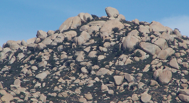
As you near the summit plateau, the slope eases up a bit and soon you’ll notice outcroppings of rocks that mark the high point of Donohoe Mountain. You have now come just under a mile from the trailhead. Take a break and enjoy the panoramic views – Otay Mountain looms large to the west/southwest, the rocky summits of Lyons Peak, Mother Grundy Peak, and White Mountain dominate the north/northeast skyline, San Miguel Mountain is the large peak topped with towers to the northwest, and the small town of Engineer Springs sits nestled in the valley below to the east, with the grey ribbon of highway 94 winding its way toward Campo and beyond.
From the top of the peak, you can see various trails below, and for a longer hike, one could descend via the far end of the mountain and pick up one of the paths to make a loop back to the trailhead. Otherwise, retrace your steps across the summit and once again drop down the slope in a southeasterly direction, exercising caution as the footing is slippery in some places. Meet the road at 1.4 miles, turn left (northeast), pass through the gate, and reach the trailhead, gate, sign, and your vehicle at just under 2 miles.
DONOHOE MOUNTAIN
Climb a mini peak in rural East County
Driving directions: (Dulzura/Engineer Springs) From CA-94 in Engineer Springs, turn south onto Marron Valley Road (labeled Cottonwood Creek Road on some maps). Follow this road past residences about 0.7 mile to the junction with the unmarked, gated Donohoe Spur Road on the right. Park on the shoulder, being careful not to block the gate or any nearby driveways. There is parking available for 3-4 vehicles. No facilities. Trailhead GPS: N32.62325, W116.77120. Hiking length: 2 miles round trip. Allow 2 hours hiking time. Difficulty: Moderate, with a section of off-trail/bushwhacking. Elevation gain/loss up to 650 feet. Donohoe Mountain can be visited year-round; however, high temperatures during the summer months may necessitate early morning or late afternoon/evening hikes.