Sponsored
Sponsored
Nestled into a quiet neighborhood at the eastern fringes of Poway is a hiking trail that goes through the riparian habitat of Poway Creek, rises steeply up into chaparral slopes, and culminates at a panoramic viewpoint known as Goat Peak. Likely known by locals for years, this trail stays largely under the radar for most everyone else. It provides a shorter alternative to the nearby Iron Mountain with far less of that summit’s crowds. Despite coming in at just over three miles, there are sections of trail steep enough to challenge even the seasoned hiker. Goat Peak can be hiked any time of year.
However, summer months can be quite hot and there is little shade.
Begin by following the wooden fence east as it skirts the side of a house and then drops to meet Poway Creek. Turn right to follow the streambed, passing under big coast live oaks and western sycamore trees, which provide just about the only shade you’ll find on this hike. Depending on the time of year and any recent rainfall, the creek may be completely dry or deep enough to warrant caution at each crossing. Beware also of poison oak that is common near water courses; the slightest touch of this plant causes itchy, burning rashes or blisters for most people. After 0.25 mile, the trail crosses the creek and then back again several times. Common riparian plants here include the fragrant mule-fat native to our region, as well as the non-native, invasive tamarisk or salt-cedar, a plant with a deep taproot that tends to suck up the water required by its neighboring native plants.
The trail continues on, and at 0.5 mile climbs gently and enters the chaparral plant community.
Various shrubs are found here, including toyon, flat-top buckwheat, white sage, spiny redberry, sawtooth goldenbush, and the occasional white-flower currant. At 0.7 mile, the trail turns decidedly steep and wastes no time gaining elevation on its beeline for the summit. The path here is quite eroded and slippery and at times sports ruts down the middle, making footing a bit awkward. Trekking poles may be of help for this section – both for assistance pushing up and also for support on the return trip. As you climb, more native shrubs line the path, including lemonadeberry, chaparral candle, manzanita, chamise, sugar bush, and ceanothus. At 0.75 mile you’ll reach a point where you can go left or right – either choice is fine as they soon re-join. However, taking a left here is the slightly less steep option. At 0.9 mile the trail levels out and forks as it reaches a small saddle (keep left here), then drops slightly and aims for a shallow wash. At 1.0 mile cross a small creek, and at 1.2 miles enter the wash.
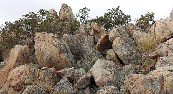
Once in the wash, you’ll encounter a few dry waterfalls, some requiring mild scrambling to climb up. Keep an eye out for chalk dudleya clinging to the rocky walls, a succulent perennial with multiple tentacle-like stems with pinkish-red flowers in late spring to early summer. At 1.3 miles you exit the wash and the trail continues up, turning quite rocky before finally cresting the summit ridge and bringing Highway 67 into view below. At this point, find a faint use trail up through the brush and rocks for the remaining distance to the top of the peak at 1.6 miles. Enjoy the panoramic view that includes other nearby Poway peaks such as Iron Mountain to the east and the boulder-strewn summit of Woodson Mountain to the north. After soaking in the vista, carefully work your way back down the rocks to the main trail and return the way you came, using extra caution for the steep slippery portions of the descent.
Directions: (Poway) From I-15, exit on Poway Road and go east for 5 miles. Just as Poway Road curves left (north), turn right onto Garden Road and continue 1.6 miles to Quiet Valley Lane. Turn right (east) and go 0.1 mile to the end of the road and park (there is room for several vehicles around the cul-de-sac). No facilities.
Hiking length: 3.25 miles round-trip. Allow 3 hours hiking time.
Difficulty: Moderate, with areas of rock scrambling. Elevation gain/loss up to 1,080 feet.