Sponsored
Sponsored
Just east of Ramona in a section of the Cleveland National Forest, one can hike high above the San Diego River Watershed along an old fire road to a dramatic viewpoint overlooking Dye Canyon, where water tumbles down more than 100 feet over cliffs after heavy rains. This rocky precipice — known as Devils Jumpoff — lies within private property so cannot be accessed by hikers.
However, a distant view of the falls from half a mile to the south is just off the West Side Road. The best time to visit this area is November through May, as summer months can be quite hot and the waterfall is likely to be dry.
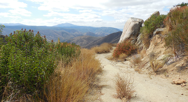
From the parking area, walk north up the last 0.1 mile of Ramona Oaks Road, toward a sign reading “NO EXIT,” to a gate blocking further vehicle access. Continue uphill as the road swings northeasterly away from the housing development and turns into dirt,
passing by common chaparral plants such as laurel sumac and flattop buckwheat.
Almost immediately, there are views to the east, including Cuyamaca Peak and the nearby Eagle Peak, the prominent mountain perched above San Diego River Canyon immediately below you. To the south the El Capitan Reservoir shimmers in the sun and the dark pyramid-shaped Viejas Mountain is visible just east of the rocky summit of El Cajon Mountain.
At just over 0.8 mile from the start, a short side path on the right brings you to an overlook with a bird’s eye view down into the San Diego River. The trail heading down to Cedar Creek Falls is clearly visible a short distance to the south as it zigzags through the chaparral-clothed slopes below. Continuing on the West Side Road, make a dip in and out of a shallow wash where a couple of small oak trees are present. Sugar bush, yucca, goldenbush, and white sage dot the scenery. After a few more twists and turns, the road turns north as it passes over the mostly indistinguishable “Tom Benchmark” labeled on some topographical maps.
After veering northwesterly and passing a large Engelmann oak tree on the left at just over 2 miles, spot an old gate off to the right and a yellow forest boundary sign where the road narrows and private property lies beyond. At this point, leave the road on one of the faint trails heading northeast through the low brush consisting mostly of chamise. After another 0.2 mile, just before the slope drops off steeply, find an open area with unobstructed views north to the rocky cleft of Devils Jumpoff about half a mile away.
Depending on the time of year and whether or not the area recently received a healthy dose of rain, the falls could be a gushing torrent or completely dry. Visit the area in spring for the best chance to see the falls running. Other views include that of the upper San Diego River watershed below, the Cuyamaca Mountains to the east, and distant peaks to the south near Alpine.
After enjoying the view, retrace your steps southwest through the bushes to reach West Side Road, turn left (south), and descend the 2 miles back to the trailhead and your vehicle.
Distance from downtown San Diego: 40 miles (Ramona). Allow 1 hour driving time. From State Route 67 in Ramona go southeast on 10th Street for 0.4 mile. Continue onto San Vicente Road for 6.4 miles. Turn left on Ramona Oaks Road and continue 3 miles through the San Diego Country Estates housing development to the intersection with Shalom Road and park on the street. No facilities.
Hiking length: 4.5 miles out-and-back.
Difficulty: Moderate. Elevation gain/loss 800 feet. Trail is open to hikers, horses, and mountain bikes