Sponsored
Sponsored
One of the most popular hikes in Anza-Borrego Desert State Park is the Borrego Palm Canyon Trail. On most weekends, there is a steady stream of people walking up this easy trail to the first palm grove in the canyon. The majority will spend time enjoying the beautiful oasis and then turn around. For those willing to be a bit more adventurous and desire to undertake a more strenuous hike, there is more to explore beyond this point.
The Palm Canyon was known to the Cahuilla Indians as “Tev ing el we wy wen it,” meaning, “a round flat basket closed up at the top, that is hung up.” It is roughly 15 miles long and was once estimated to contain around 3000 fan palms before a devastating flood in September 2004 greatly reduced their numbers. Still, within 3 miles of the trailhead, you can discover three spectacular groves of California fan palms, the only native palm in California. They are relics from a cooler and moister period and are now restricted to the isolated rocky canyons of our desert regions where underground springs provide the large quantities of water they need to survive. The California fan palm is distinct from the much more common non-native Mexican fan palm of landscaping fame. It was an important food source for the Cahuilla and, although it does not produce dates, it does have a fruit with a thin pulp covering the seed that has a taste similar to molasses. These fruits were eaten either fresh or dried, and the seeds were ground into flour. The fruits were also soaked to make a sweet beverage and could even be made into jelly. Tribal shamans would burn the skirts formed by the dead palm fronds to help manage insect populations and allow for healthier palms that would produce better yields. The leaves could be woven into sandals, used to thatch roofs, and even turned into baskets.
Growing to heights between 50 and 70 feet and up to 20 feet in diameter, they are often found in large groups of up to 100 or more. While lacking the annual growth rings of true trees, making age estimates difficult, experts estimate that these palms can live from 150 to 200 years. These groves make a unique desert environment for wildlife and are home for many species of birds, insects, frogs, snakes, rodents, mountain lion, and bighorn sheep. Without this habitat, many of these species would probably not be able to survive in such an arid region.
After paying the entrance fee, drive to the trailhead that starts from the western-most parking lot in the Borrego Palm Canyon Campground. After parking, you may want to visit the small pond where the endangered desert pupfish can be found. This hardy little fish is now restricted to a very small area of its former habitat, which is generally too harsh for most introduced species to exist.
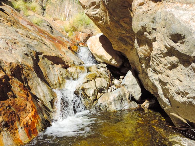
From the pond, follow the well-marked trail up the canyon for about 1.5 miles to the first palm grove. Multiple stream crossings may be needed due to rainfall, and may have a few places where rock scrambling is necessary. Enjoy a short break in the shade of the palms and prepare for the more strenuous 1.5 miles ahead. Now retrace your steps for about 100 yards and find the trail on the east side of the canyon leading upward. While this trail starts out easy to follow, it will quickly disappear and you will find yourself making your own choices as the best way to continue up the canyon. Some challenging rock scrambling and multiple creek crossings will be necessary while passing through the canyon. If rain has been plentiful, there may be small waterfalls and pools in this section. These pools are habitat for the small California treefrog that are a challenge to see, as their coloration blends in well with the rocks. Bighorn sheep can often be spotted on the steep slopes of the canyon, though luck will be needed to see movement while looking in their direction. At just under 3 miles from the starting point is the second palm grove of the day. You may decide to make this your turnaround point or to continue on several hundred more yards to the third and final palm grove that will be the turnaround point for this hike.
Another option is to continue to the very strenuous climb up Indianhead, which is a much more challenging hike and requires good physical endurance and plenty of pre-hike planning. After taking in the beauty of the canyon, retrace your steps back to the first grove. The trail splits about 0.5 mile past the grove. A left turn returns to the main trail and the path originally taken, while continuing straight will be a slightly longer and steeper alternate trail before returning to where you parked.
Distance from downtown San Diego: About 86 miles. Allow about 2 hours driving time (Borrego Springs). From Ramona, drive east on SR-78 to Santa Ysabel. Turn north on SR-79 and drive to the junction with SR-2/San Felipe Road and turn southeast. At the junction with SR-22, turn east to Ranchita and follow SR-22 to the stop sign in Borrego Springs. Turn left and then immediately right, driving to the entrance of Borrego Palm Canyon Campground. Pay the day-use fee ($10 as of January 2017) at the entrance. Drive to the west end of the campground and park at the trailhead near the campfire circle. Overnight camping also available for a fee. Best to make camping reservation in advance, which can be done online.
Hiking Length: 6 miles out-and-back hike.
Difficulty: Difficult, with approximately 800 feet of elevation gain/loss. The beginning 1.5 miles is relatively easy on well-marked trails. After the first grove, there is no marked trail and some boulder scrambling and stream crossings will be required for the next 1.5 miles. Be sure to carry plenty of water, as dehydration is a major concern. Facilities and water at the trailhead.