Sponsored
Sponsored
Carmel Mountain Preserve encompasses about 300 acres overlooking Torrey Pines State Natural Reserve with views of the ocean and, in wet springs, the trail passes within close proximity to several small vernal pools. This is generally an easy trail with only a couple of spots that are steep and rocky. It is best to visit in the late winter/early spring months to see the vernal pools.
From Fairport Way at the kiosk, go up a short hill and take the first trail on the left. At this point, be careful of your footing, as the ground is covered by small marble-sized concretions. Geologically, concretions form after sediments are buried but before the sediment solidifies into solid rock. They typically form when a mineral precipitates and cements sediment around a nucleus, which is often organic, such as a leaf, tooth, or piece of shell. The concretions found at Carmel Mountain Preserve were created by concentric growth. In concentric growth, the concretion grows as successive layers of mineral precipitate around the central core, resulting in roughly spherical concretions. With ongoing erosion of the overlying material, the concretions appear at the surface as the surrounding material erodes away.
Shortly, you will come to an area that contains numerous vernal pools. Due to past transgressions, many of the vernal pools in this area have been damaged and are currently being managed to return them to their glory. The trails are mostly lined with cables in this area to remind users to avoid the pools. Remember, even though the pools may be dry later in the season, hiking, biking, and horse riding through them can cause damage. After rains when there is water in the vernal pools, check them out for tadpoles, fairy shrimp, and plants that are endemic to this ecosystem.
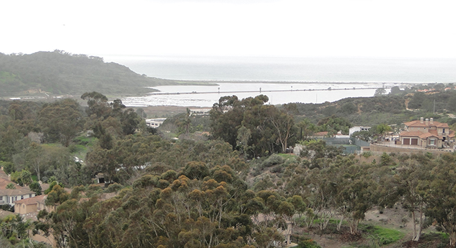
Continue along the trail in a westerly direction, past the utility lines, and you will come to a viewpoint over Peñasquitos Lagoon. From here, it’s a very steep descent over the sandstone substrate. After carefully making your way down the slope, follow the trail to the eucalyptus grove. There is a gradual climb through southern maritime chaparral, filled with toyon, lemonade berry, laurel sumac, wild cucumber, and black sage. Walk up through the draw, where the trail slowly transitions through coastal sage scrub habitat. This area is dominated by the white-flowered wart-stem ceanothus (C. verrucosus), prickly pear cactus, and coastal sagebrush. Soon you will return to the original plateau, but almost immediately, there is a trail off to the left that goes to another viewpoint overlooking the lagoon; it is about 0.4 mile over mostly level ground.
Walk back from the viewpoint then go to the left on the utility-line service road that drops then rises abruptly again, going through a small draw. Once back up on level ground, continue until you come to a right turn in the trail. A wide area here offers yet another view, this time looking to the north toward Carmel Valley.
Continuing on the trail, there are several intersections coming up. At the first split, stay straight, avoiding the shortcut trail to the right. At the second intersection, stay to the right and soon you will come to a right bend in the trail and another vernal pool site. At the next intersection, turn right, then keep to the left past three trails to continue south back to the Fairport Way trailhead.
Distance from downtown San Diego: 18 miles. Allow 25 minutes driving time. (Carmel Valley). From I-15N, take the “Local bypass” in the Sorrento Valley area. Leave the freeway at exit 32 (Carmel Mountain Road) and turn right on Carmel Mountain Road. Follow it east for 0.4 mile and turn right to stay on Carmel Mountain Road. Follow it another 0.8 mile and turn left on E Ocean Air Drive. Follow it 0.3 mile to Ocean Air Community Park at 4770 Fairport Way (San Diego, 92130). Park either in the first spaces of the community center or turn left at Fairport Way and park near the trailhead just west of the community center.
Hiking length: About 3 miles roundtrip.
Difficulty: Moderate, with 200 feet elevation loss/gain, some areas slippery or steep. Facilities in community center.