Sponsored
Sponsored
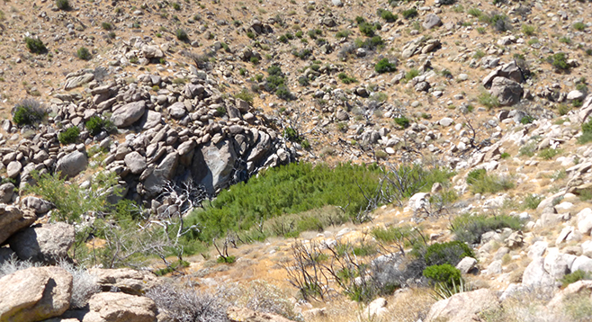
Big Spring is one of the dependable watering holes for desert bighorn sheep. It is found in a tributary of upper Tubb Canyon and is easily accessible. The trail within the spring area is jungle-like with heavy vegetation. An extra treat on this hike is a slight diversion to a great view of Borrego Valley at the head of the middle fork of Tubb Canyon.
The trail to Big Spring departs from just south of the large turnout on S-22, crossing over a low divide into the sandy middle fork of upper Tubb Canyon and then over another low divide to the south fork of upper Tubb. Big Spring is about a mile from the highway in the latter fork and is heavily overgrown with mule-fat or seep-willow, catclaw acacia, mesquite, and cottonwood. Big Spring is a reliable water producer in the Anza-Borrego area, flowing on the shrub-choked surface for one-quarter mile, then going underground. The spring is a main watering hole for bighorn sheep and other wildlife. Look for tracks of wildlife in the area.
The lower canyon below the spring is on private property — do not hike down. Follow a use-trail through the vegetation to the west, taking care to avoid contact with thorny catclaw acacia and mesquite. Just above the spring are some boulders, which is a good place to rest. Dropping down from the boulders leads to the canyon bottom above the spring and below Pinyon Ridge. There is an option for exploring the upper reaches of the canyon or climbing the ridge north and dropping down to return to the main trail, which can increase the overall mileage of this hike. Otherwise, retrace your steps on the return hike.
On the way back from the spring, go over the rise to the east leading to the upper area of the middle fork of Tubb Canyon for a great view down the canyon and into Borrego Valley, about 2500 feet below.
Because this trail is at a higher elevation, it can comfortably be hiked late into the desert season, especially in the early morning or late afternoon. Like any other desert trail, be sure to carry water, wear a hat, and use sunscreen.
Distance from downtown San Diego: 81 miles (Anza-Borrego-Desert State Park). Allow 1.5 hours driving time. From SR-163N/I-15N, go east onto Scripps Poway Parkway to the end, then north onto SR-67. Continue east through Ramona on SR-78 to Santa Ysabel’s intersection and turn north on SR-79. Drive just past the power station before turning right onto S-2/San Felipe Road for about 5 miles, then turn left onto S-22/Montezuma Highway. Drive just past mile-marker 11 on S-22 to the large turnout on the north (left) side of the road and park. The trailhead is across the highway.
Hiking length: 2 miles out and back.
Difficulty: Easy. Elevation gain/loss 200 feet. Bicycles and dogs not allowed. No facilities.