Sponsored
Sponsored
Along with ease of access and walkability, a unique feature of 32nd Street Open Space is the breadth of variety of the most common chaparral plants found across the county, which include California sagebrush, laurel sumac, lemonadeberry, and toyon alongside three of our most common baccharis bushes that dot the canyon slopes. It is also a good place to identify native plants in all seasons.
The welcome sign to this open-space area is among a healthy stand of baccharis. Slightly to the west is a wide opening with two posts with light-colored bark at the trailhead. California sagebrush is prevalent along the start of the trail with yellow flowers of bladderpod bush giving color while, depending on the time of year, there are dried flowers of black sage, laurel sumac, goldenbush, and baccharis. Notice the difference between male and female flowers on the deciduous baccharis.
Growing along the trail edge are three examples of the mint family. Most have square stems that are easily seen or felt as on horehound or black sage. White sage differs, as the hollow stems look round though all have a scent when the leaves are rubbed. Next time you are at the store or nursery, feel the square stems of cultivated mint-family members that include peppermint and spearmint. Note the whorled opposite leaves and bilaterally symmetrical flowers with a four-lobed ovary divided into four one-seeded nutlets.
Depending on the time of year, evening primrose is either a yellow showy flower or dried “candle wicks” along low runoff areas where there is also willow and mulefat. Native sycamore trees plus Peruvian and Brazilian pepper trees are scattered along the canyon sides. While nonnative, they are used extensively as landscape trees for their draping gracefulness.
Look up the eastern slope at the end of Golden Hill Elementary School just beyond a patch of bunch grass. There is evidence of the Lindavista Formation in a layer of cobbles at the bottom. The presence of the river-rounded rocks were a mystery that was not solved until the late 1950s and early 1960s, after seafloor spreading was validated, leading to acceptance by the geoscientific community of the plate-tectonic theory. The rocks originated in Sonora, Mexico, traveling northwest approximately one inch a year.
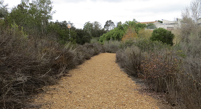
The trail surface randomly changes between shredded bark and dirt with one section bordered by cobbles. Toward the end there are three members of the sumac family within touching distance, making it a good place to note the differences between lemonadeberry, laurel sumac, and sugar bush, which is normally at a higher elevation.
The hike turn-around point is just below Cedar Street, where there’s private property and a steep rise of greater than 25 percent of easily eroded marine terraces that are characteristic of the coastal plain region.
Distance from downtown San Diego: approximately 3.1 miles. Allow 14 minutes driving time (Golden Hill). Head east on Broadway then left onto 13th Street. Turn right onto C Street for about 1.7 miles with the entrance on the left (Golden Hill Elementary School is too far). The trailhead is wide with light bark and two posts. Street parking only.
Hiking length: approximately 1 mile out and back.
Difficulty: Easy, with elevation gain/loss of 200 ft. Dogs allowed on leashes. No facilities.