Sponsored
Sponsored
While Cuyamaca Peak gets all the fame as being San Diego County’s second-highest peak at 6512 feet, its lesser-known neighbor to the south, Japacha Peak, sports panoramic views without antenna towers adorning the summit.
This loop hike incorporates several trails in the park’s West Mesa, making a gradual ascent of the peak before traversing northward through forest canopy and finally dropping down through Fern Flat and turning back south via the West Side Trail. The collection of trails is a good choice for seeing a variety of plants in the chaparral and mixed conifer forest communities. The best time to visit this area is from October through June, as the summer months can be quite warm and thunderstorms are not uncommon by midday.
Start the hike by carefully crossing the highway from the parking area to the signed and gated West Mesa Fire Road. Follow this road southwest as it parallels a small creek bed passing by patches of buckwheat, wild rose, blue elderberry, and the occasional woolley mullein. After climbing about 300 feet in 0.6 mile, reach the junction with the West Mesa Loop Fire Road on your right.
Take this fire road as it climbs northwesterly, where manzanita shrubs and lupine line the edges. Blue elderberry continues on this stretch, and soon a few small Coulter pines make an appearance. Further along, look for black oaks and mountain mahogany, as well as a nice view of Stonewall Peak to the north. After another 300 feet of climbing and close to 1.5 miles from the start, turn left (west) onto the West Mesa Trail and pass through brush making a strong comeback after the 2003 Cedar Fire. The lower slopes of Japacha Peak can be seen straight ahead and almost 1000 feet higher. Penstemon is prevalent trailside here, and a few small cedars pop up. A drainage high above Japacha Spring is crossed, where both poison oak and its harmless lookalike, basket bush, is found.
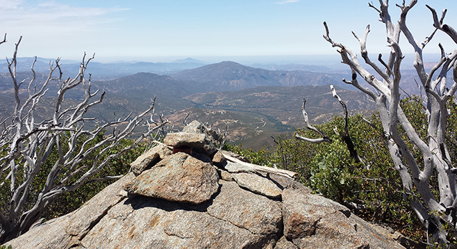
Continue left on the West Mesa Trail past Fir Trail. Pass through open slopes with great views of a grassy plateau to the southeast known as East Mesa. The trail is then shaded by stands of oak, pine, and cedar before reaching the junction with the Burnt Pine Trail at just under 3 miles from the trailhead. Turn right onto Burnt Pine Trail and ascend several switchbacks as the trail tunnels through vegetation thick with manzanita and ceanothus. Eventually the trail levels to a little saddle just north of Japacha Peak, marked by a large pile of rocks where there is a narrow, faint path through the brush, leaving the main trail used to reach the summit. This faint path leads to an open spot next to a rocky outcrop at the brink of a drop-off that serves as a great viewpoint to the west. Go to the far left of this viewpoint and spot an obscure path, marked by a small cairn that goes south up the slope through overgrown shrubs.
Work your way up the trail as it hugs the west side of the peak and at times uses rock bands for easier travel. The route angles over toward the center of the ridge and is periodically marked with rock cairns to aid in navigation. Pay careful attention to landmarks on your way in, and a GPS may be handy as a backup tool. A couple of larger rocks mark the summit where there is peak register to sign. Enjoy the panoramic view that includes Cuyamaca Peak looming about 700 feet higher to the north, the sharply pointed Stonewall Peak to the northeast, and many more peaks and valleys to the south and west. Then, carefully work your way back north down to the viewpoint and the main trail.
Continue north on the Burnt Pine Trail with Middle and North Peaks coming into view, as well as Cuyamaca Lake. At the Conejos Trail junction, keep to the right. This segment of the trail alternates between open terrain and forest canopy, with patches of ferns and scarlet monardella. Near the junction with the Lookout Road, look left through a narrow opening in the trees to spot the summit of Cuyamaca Peak and its crown of towers.
Turn right onto the paved Lookout Road and descend through the cover of mixed conifers followed by open terrain with paintbrush and goldenbush along the road. Pass a water tank a short distance later and continue downhill until turning right onto the West Side Trail. The trail has a fair amount of shade and after vigorous regrowth of brush it has made a tunnel-like roof overhead. Burnt trees lean over the trail as it winds in and out of shady recesses and passes by colorful surprises such as western choke-cherry and columbine. The trail pulls close to CA-79 before finally reaching the West Mesa Fire Road and trailhead, completing the 10-mile loop. Turn left to step through the gate and carefully cross the highway back to your vehicle.
Distance from downtown San Diego: 48 miles (Cuyamaca Rancho State Park). Allow 55 minutes driving time. From I-8E, take exit 40 for CA-79/Descanso. Drive north on CA-79 for 2.7 miles, then turn left to continue on CA-79 for another 7.2 miles to reach the signed West Mesa Parking area on the right shoulder. No facilities.
Hiking length: 10-mile loop.
Difficulty: Moderately strenuous. Elevation gain/loss of 1860 feet. Most trail junctions are well marked and easy to follow, with the exception of the side path leading to Japacha Peak’s summit that can be difficult to locate and is somewhat overgrown with low brush.