Sponsored
Sponsored
The Trans-County Trail is one of several regional trail systems being developed in San Diego County. The Regional Trails Plan includes a total of nine trails that will eventually provide significant north-south and east-west trail corridors in the county. The Trans-County Trail runs east to west over approximately 110 miles from the Salton Sea to the ocean at Torrey Pines. About 70 percent of the trail is over existing trails in the county and is currently open to the public. This section of the trail follows along the Peñasquitos Creek riparian zone from Black Mountain Road east, crossing under I-15 and continuing on for a short distance. This hike includes a scenic loop with great views and diverse chaparral species.
From the parking area, walk down toward the creek and follow the trail that crosses under Black Mountain Road and continues east toward Mercy Road. This well-marked trail is signed “Trans-County Trail.” For the first quarter of a mile, you will be walking along the side of the stables on your left. Once past the stables, the trail will drop down along the riparian zone of Peñasquitos Creek.
From this point until crossing under I-15, there will be a profusion of wildflowers in spring and early summer. If hiking during this time, there will be an impressive display of the fuchsia-flowering gooseberry. Much of the trail is shaded by sycamores, coast live oaks, and willows, and will cross the creek a couple of times on well-constructed foot bridges. Just past the first bridge on the right is a pool that is home to fish, crayfish, and other aquatic animals. Look for water striders, also called pond skaters, that are true bugs in the family Gerridae that will be flitting around on the surface. These are delicate water-based insects that can literally “walk on water.” Because of this ability, they have also been called Jesus bugs. They wait for other insects to fall in the water that will become their prey.
Once you pass the second crossing, there are fewer trees close to the trail and more open space that provides many opportunities throughout the season for viewing flowering plants, such as monkeyflowers, goldenbush, buckwheat, and datura. Ahead will be the undercrossing at I-15. Once on the other end, you will cross under the Los Peñasquitos Arch Bridge that was in use until I-15 was completed. This old highway bridge is still in use but only as a bike trail. In 1995 the new bridge was renamed the Cara Knott Memorial Bridge after the San Diego State University student who was killed in the area in 1986.
This is where the 3-mile hike ends by turning back and retracing your steps to your vehicle. For the longer loop hike, continue down this road and skirt around the City of Poway’s pump station. On the back side of the station the trail climbs for a short distance to an old road bed and then continues with a gradual uphill climb through many common chaparral species. After about 0.5 mile, there is an unmarked trail off to the right that heads up a fairly steep but short climb to a saddle on the ridge. This is the high point on the trip where there is a good view of the east end of Los Peñasquitos Canyon. Continue on down the trail to the east to join the main trail close to the creek.
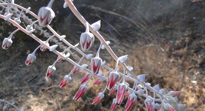
When you meet up with the main trail, turn to the left to begin the loop and the return trip. Since this is now on the north-facing slope, there are many flowering plants including toyon and dudleyas. Toyon is also called Christmas berry and is a prominent evergreen shrub or small tree found in coastal sage scrub and chaparral communities. The white summer flowers turn into red berries in winter. Dudleyas are also prominent. They are hardy succulent perennials that can thrive in dry climates, earning their common name as “liveforever.”
This is also a great place to take in a great view of the old highway bridge with the much larger I-15 bridge looming overhead. Continuing on the trail, you will eventually complete the loop and return to the main trail. Go left (west) to return to the parking area via the same trail.
Distance from downtown San Diego: 18 miles. Allow 30 minutes driving time (Rancho Peñasquitos). Exit I-15 N at Mercy Rd./Scripps-Poway Pkwy. and follow Mercy Rd. west for 2.6 miles to Black Mtn Rd. and turn right (north). Park at the entrance to Los Peñasquitos Canyon Preserve on the left (west). There is a $3 parking fee. Hiking length: 3 or 5 miles out-and-back with extended loop. Difficulty: Easy. Elevation gain/loss about 100 feet. Follows a well-maintained trail. Mountain bikes and dogs allowed. The shorter hike is good for children.