Sponsored
Sponsored
Los Peñasquitos Canyon Preserve is a 4000-acre open-space area that includes both Los Peñasquitos Canyon and Lopez Canyon. Both canyons may be accessed from a western approach. The canyon walls are responsible for its name (“little cliffs” in Spanish) and the name of the first Mexican land grant in California — Santa Maria de los Peñasquitos, granted to Francisco de Maria Ruíz in 1823. Ruíz was unhappy with the grant because he felt it was not good for cattle grazing, so he requested additional land to the west called El Cuervo, which was granted to him in 1834. He built an adobe home near the confluence of Lopez Creek and Peñasquitos Creek that later became known as the El Cuervo adobe, possibly because crows (Spanish meaning) roosted there. The Ruíz heirs abandoned the adobe when they built a new elaborate home at the east end of the canyon around 1860.
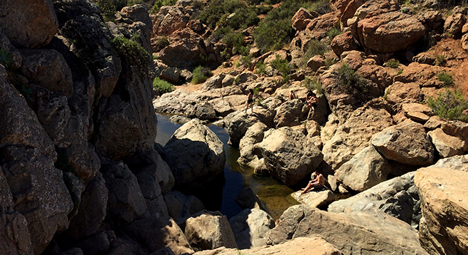
The highlight of this hike is the visit to Peñasquitos Creek Falls, a waterfall and associated ponds carved in volcanic rocks at the midpoint of Los Peñasquitos Canyon, one of many large canyons in San Diego that cut through mesas from the foothills of the mountains to the coast. The falls is a popular place to hang out on rocky ledges overlooking the pools before turning back.
The trail begins amid dense vegetation along Lopez Creek, which opens up into a clearing with a choice of continuing east along Lopez Creek into Lopez Canyon (see 5/22/2013 Roam-O-Rama) or heading north underneath Sorrento Valley Boulevard per this walk description.
Once in Los Peñasquitos Canyon, turn west for a short side trip of about 1500 feet to see the historic El Cuervo adobe ruin that lies between the Peñasquitos Creek and Sorrento Valley Boulevard under a protective roof. Cattle continued to graze these lands for hundreds of years, first with the Ruíz family and then, beginning in the 1840s, with the Lopez family, who had their operation in the adjacent canyon southeast of the boulevard.
The trail to the waterfall is 3 miles from the adobe and oriented in a northeasterly direction at varying distances from Peñasquitos Creek. Near Peñasquitos Creek are riparian woodlands that consist of trees such as the western sycamore, arroyo willow, cottonwood, mule fat, coast live oak, and other oak species. Away from the creek are grassy meadows, rolling hills, steep canyon walls, and chaparral and coastal sage scrub plant communities.
Chaparral and sage scrub species in Los Peñasquitos Canyon include lemonadeberry, laurel sumac, toyon, manzanita, elderberry, gooseberry, chamise, California sagebrush, California buckwheat, black and white sage, chaparral broom, coyote brush, goldenbush, wild cucumber, monkeyflower, and ramona lilac.
On a typical daytime hike, you can see (or hear) many bird species along with butterflies and other insects. Birds commonly sighted in and about the canyon include hawks, ravens, crows, coots, mallards, quail, mourning doves, egrets, herons, hummingbirds, black phoebes, bluebirds, mockingbirds, thrashers, blackbirds, bushtits, wrentits, finches, and towhees.
Watch along the trail for scat that has fur and or seeds that most likely is evidence of coyotes, and small mounds of dirt indicating the presence of gophers. Other wildlife known to inhabit or visit the canyon includes raccoons, bobcats, mule deer, mountain lions, lizards, and snakes. Look for their tracks on the trail and keep alert for a sighting. Fish, frogs, and crayfish are in the creek.
Distance from downtown San Diego: 14 miles. Allow 20 minutes driving time (Sorrento Valley). Take I-805 N and exit at Vista Sorrento Parkway. Continue on Vista Sorrento Parkway 1.7 miles to Sorrento Valley Rd. and turn right (east). The trailhead is about 1 mile east of that intersection on the right (south) side of Sorrento Valley Rd. A driveway leads to a large asphalt lot that may close after a rain.
Hiking length: Approximately 6 miles.
Difficulty: Easy, with an elevation gain/loss of 200 feet until the falls. The wide dirt trail is rocky in spots; slippery rocks at the falls. Equestrians, bicycles, and dogs (on leashes) allowed. Facilities.