Sponsored
Sponsored
The Crestridge Ecological Reserve is one of 16 California Department of Fish and Wildlife Ecological Reserves in San Diego County. The current 136 statewide ecological reserves provide habitat for a wide diversity of plant and animal species and preserve habitats from every major ecosystem. Crestridge has close to 3000 acres that preserves a core block of habitats identified by the San Diego Multiple Species Conservation Program (MSCP) that serve as a link between the northern and southern parts of the county. The purpose of the MSCP is not only to preserve San Diego’s native habitats and wildlife for future generations, but also to protect federally listed endangered species.
Vegetation types found within the reserve include coastal sage scrub, chaparral, oak woodlands, riparian, and grassland. Two rare plant species, Lakeside lilac and thornmint, plus insects of concern that include Hermes copper butterfly and Harbison’s dun skipper are within the reserve. It is also home to hawks, owls, woodpeckers, gnatcatchers, southern mule deer, coyotes, bobcats, foxes, mountain lions, horned lizards, and rattlesnakes.
There are many access points to Crestridge in the surrounding urban interface, so please be considerate of the neighbors and avoid access to their homes and private property by using the official entrance at Horsemill Road. Trails leading east and west radiate like the wings of a bird from the hub of the reserve at the official Horsemill Road entrance.
When you arrive, examine the map on the kiosk, and if available, pick up a trail map. The trails zigzag, climb, and loop for miles throughout much of the reserve. It is possible to hike over 20 miles and seldom travel the same route. Trails are made up of fire roads, truck trails, and hiking and horseback riding paths with some of the trails eroded to the point of decommission. Earth Discovery Institute, Endangered Habitats Conservancy, and the San Diego Mountain Biking Association have partnered to reroute and repair many of the trails to reduce erosion.
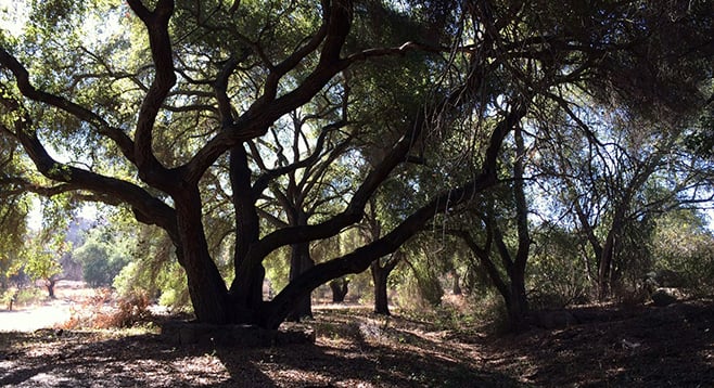
A popular route is the 3-mile Valley View Truck Trail that has less than 500 feet of elevation gain. From the Horsemill Road entrance, follow the dirt road northwest or left through a riparian woodland of coast live oaks and Engelmann oaks. As you exit the woods, take the north-most trail to the right, up and into the coastal sage scrub/chaparral habitat. This fire road runs along the north edge of the reserve where there are private avocado orchards that grow down to the urban interface with I-8. This route is popular with runners and equestrians and can be followed out of the reserve and all the way to the shopping-center parking lot on Los Coches Road. Distance markers are placed along the route every 0.5 mile within the reserve. At the western edge of the reserve is a heavy, yellow-painted metal gate that is about 3.5 miles from the Horsemill entrance.
To make this a loop hike, turn left or south at mile 1.8 onto a single track and climb. Stay right at forks until you reach a boulder-studded high point at 2.8 miles with stunning views. The view includes El Cajon, Lake Jennings, and glimpses of the Pacific Ocean on a clear day. This also can be an out-and-back or, for the more adventurous, a 4-mile loop. Head east down the single-track trail from the high point, taking an old roadway north to a T-junction. To the right, the trail eventually leads to the Valley View Truck Trail, heading east and back to the Horsemill Road entrance to complete the loop.
For a simple mile-long hike, start east of the James Hubbell–straw-bale-built shelter and head northeast up a signed trail. Climbing past the blackened woody remains of the 2003 Cedar Fire, you will find Engelmann oak among the sumac, California buckwheat, and chamise along the trail. At the top, head left or west at the Y-junction to an overlook of east El Cajon and the San Diego River watershed to the north. The trail loops back down to the southwest past a large-scale native grassland restoration project with hundreds of protective plant cones. This is a multi-year habitat-restoration effort that has included over 20,000 school students. They have visited on science/service-learning field trips coordinated by the Endangered Habitats Conservancy’s education/outreach partner, Earth Discovery Institute. The trail ends at the oak grove. From here there is a path leading through the oaks to boulders that have morteros where the Kumeyaay ground acorns into meal.
Distance from downtown San Diego: 25 miles. Allow 35 minutes driving time (Crest). Take I-8 E and exit at Greenfield Dr. Turn right (south) on Greenfield Dr. and then left onto La Cresta Dr. Near the summit, turn left onto Mountain View Rd., and in a mile turn left onto Horsemill Rd. Proceed to the cul-de-sac and the signed entry to the reserve. Hiking Length: 1 to 15 miles on loops or out-and-back.
Difficulty: Easy to difficult, depending on route selected. Elevation gain/loss varies according to route. Dogs (on leashes) allowed. Horses and mountain bikes permitted on designated trails. Facilities. Informational kiosk and trail maps.