Sponsored
Sponsored
The 6100-acre Hollenbeck Canyon Wildlife Area is managed by the California Department of Fish and Wildlife. It was once part of a Mexican land grant given in 1831 to Pio Pico, the last Mexican governor of California, which became known as Rancho Jamul. The property went through several ownerships and was eventually sold to a former San Diego mayor in 1916 and then to the Daley family in 1929; they used the property as a truck farm and cattle ranch until they, in turn, sold the property to the California Department of Fish and Wildlife in 2001. The property was designated as a wildlife area that same year. It is important as a wildlife corridor and for the variety of habitats found on the property, which include coastal sage scrub, chaparral, oak woodlands, riparian forests, freshwater marshes, and grasslands.
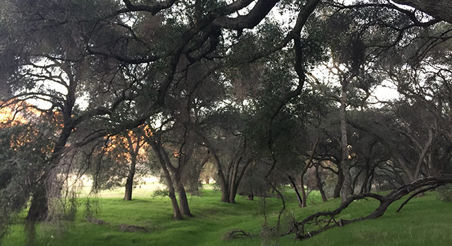
From the trailhead it is 0.3 mile to Hollenbeck Canyon and the magnificent old oaks that establish its riparian corridor. A seasonal stream runs through the wide-mouthed canyon from Lyons Valley. A complete loop can be hiked by crossing the streambed and taking the trail at the T to the left or right. The trail’s right fork goes up Hollenbeck Canyon along the wooded stream corridor of coast live oaks, California sycamore, willow, mule-fat, poison oak, and other riparian vegetation. Engelmann oak and coastal sage scrub communities grow on the hillsides above the canyon. Except in severe drought, there are a few places where standing water can be found in the creek bed.
Large clumps of San Diego sedge (Carex spissa), host plant to the rare Harbison’s dun skipper or sedge witch (Euphyes vestris harbisonii) are found here. Look for a grass-like plant and see if you can identify a sedge: “Sedges have edges, rushes are round, grasses have knees that bend to the ground.” Then look for the small skipper butterfly that has yellow-orange undersides and brown-black wings. The species name vestris refers to an Italian dancing master in the court of Louis XVI who was considered the greatest dancer of his day. The skipper’s quick, darting flight patterns call to mind the master’s intricate dance patterns.
Where the trail forks, at about 1.5 miles, take the trail to the left and climb up to a high vantage point. From here, look south to Otay Mountains and east to Lyons Peak (3722 feet). At 1.9 miles, the trail forks again; the right fork follows an old truck trail onto private property. Stay left and hike the fire road/trail down to Jamul Creek, another seasonal drainage hosting coast live oak and beautiful California sycamore. Within a mile, there will be fences and holding pens — relics of days gone by. Stay on the trail, crossing the streambed and cutting back east to catch the dirt road up and across large fields of non-native pasture grass. This area was grazed, plowed, and cultivated for decades before it was acquired by the California Department of Fish and Wildlife. The trail crosses the open, rolling foothills for 2 miles before returning to the pleasant shade of Hollenbeck’s mother oaks to complete the loop.
In winter, this can be a luscious green hike with waterfalls and wildflowers. If it has rained, be prepared for creek crossings. In summertime, the exposed sections of the trail can be hot and dry. The trail is best hiked between October and June. Wear a hat and bring plenty of water.
Distance from downtown San Diego: 24 miles. Allow 35 minutes driving time (Jamul). From SR-94 E, continue on SR-94 E/Campo Rd., then turn left (east) on Honey Springs Rd. for 0.1 mile before another left (north) into a large dirt parking lot.
Hiking Length: 6.4-mile loop.
Difficulty: Moderate. Elevation gain/loss up to 1500 feet. Open for hiking, horseback riding, mountain biking, bird watching, and seasonal bird hunting (September 1 through January). Dogs (on leashes) allowed. Memorial benches along the trail offer rest stops. Facilities. No water.