Sponsored
Sponsored
This hike offers an opportunity to experience the beauty and diversity of the Cuyamaca Mountains. The loop travels along Cold Stream Creek under shady, ancient oaks with the sound of water gently flowing over rocks, then continues up to Stonewall Creek before ascending through chaparral where a wide variety of flowering shrubs and wildflowers can be seen when in season. The route then continues to the Soapstone Grade grasslands with views down to the large meadow east of Lake Cuyamaca and North Peak beyond. At the top of the loop, it crosses a chaparral-covered ridge before descending to the Sweetwater River in Upper Green Valley, where tall Jeffrey pines and interior live oaks, as well as more wildflowers, may be seen.
Start at the south end of the West Mesa parking area and walk east a short distance across Cold Stream to the Cold Stream Trail. Turn left and continue northwest through black and interior live oak trees for about 0.2 mile to Cold Spring. The trees were only slightly damaged by the 2003 Cedar Fire at this section of the park where the spring fills a barrel designed as a watering spot for horses.
Leave Cold Stream Trail, turning right onto the Cold Spring Trail. Continue northeast for 1.4 miles, over a ridge and down to Stonewall Creek. The creek flows intermittently during the rainy season but is likely to be dry by early spring. Cross the creek bed and just beyond it will be the Stonewall Creek Fire Road (SCFR). Turn left (north) for 1.46 miles along the west-facing slope of the canyon, passing the signed Vern Whitaker trail and continuing on the SCFR, which follows a low ridge above a large expanse of grassland, sloping down to the meadows east of Lake Cuyamaca to the Soapstone Grade Fire Road (SGFR). Turn right (east) onto the SGFR as it gradually climbs toward a more distant chaparral-covered ridge.
Notice the white streak on this ridge, an outcropping of metamorphic rock extending for about a mile, just under the ridgeline. This is the soapstone for which this grade was named. Soapstone is a very soft rock, easily scratched and often used for sculpture. Some Native Americans carved bowls from soapstone. More recently soapstone is mined for its talc content — baby powder and talcum powder are both composed of talc and it has industrial uses as well.
At 0.9 mile from its junction with the SCFR, a California Riding and Hiking Trail branches off to the left of the SGFR. Ignore it. Continue straight ahead on the SGFR as it begins to descend into Upper Green Valley. In about 0.3 mile you will cross the soapstone outcropping noticed earlier. Here the road goes over whitish-gray soapstone rocks embedded in the roadway. Try scratching these soft rocks with a key or your fingernails, as many others passing this way have done.
You reach the Sweetwater River and the Upper Green Valley Fire Road (UGVFR) at the bottom of the grade. Go right (south) on the UGVFR and continue for 2.9 miles. Thick riparian vegetation hides the river initially with the river valley gradually widening to become rolling grassland, with scattered inland live oaks and nearly mature Jeffrey pines.
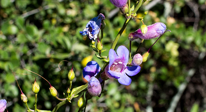
Usually there is a grand display of wildflowers in late May and early June that include summer snow, cream cups, wine cup clarkia, Cuyamaca penstemon, and Chinese houses, among many others. In places, Rancher’s fiddleneck and owl’s clover carpet the ground with thousands of blooms.
After traveling 2.5 miles on the UGVFR, you reach the southern end of the SCFR branching off to the right. Walk past and continue straight ahead on the UGVFR for another 0.4 mile and find the Hill Trail on your right that takes you west, a shortcut back to the Cold Stream trail. Turn right going north and after another 0.7 mile the loop is completed and you re-cross Cold Stream to arrive back at the West Mesa Parking area trailhead.
Mountain-bike route: From the visitor center, ride north on Upper Green Valley Fire Road and turn left (northwest) on the Stonewall Creek Fire Road. Turn right (east) on the Soapstone Grade Fire Road, then right (south) on the Upper Green Valley Fire Road to return to the visitor center while avoiding the trails.
Distance from downtown San Diego: 50 miles. Allow 1 hour driving time (Cuyamaca Mountains). Take I-8 E and exit at SR-79/Japatul Valley Rd. Drive north on SR-79 approximately 10 miles to the signed “West Mesa Parking” area on the right. The trail begins at the south end of the parking area.
Hiking length: 7.8-mile loop.
Difficulty: Moderately strenuous. Elevation gain/loss about 1500 feet. No facilities or water. Dogs not allowed. Mountain bikes allowed on fire roads but not on trails. Best time to visit is October through June. Wildflowers are best March through June.