Sponsored
Sponsored
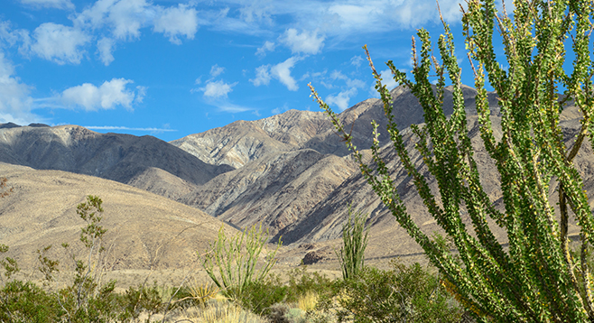
Rattlesnake Canyon is a large, deep canyon at the southern end of the Santa Rosa Mountains and one of the few canyons that flow north to south. It is a major conduit for alluvial material eroded from the Santa Rosas flowing into the Anza-Borrego desert. Here, one gets a look at the power water has to erode stone and rearrange the landscape.
Begin hiking north across a sandy alluvial plain dotted with large ocotillo, creosote bush, and clumps of galleta grass. Initially the trail is not well marked except by footprints of those who have hiked this way before. Further ahead, the trail will be well marked with frequent cairns. The Santa Rosa Mountains and Rattlesnake Canyon are directly ahead, but they look closer than they are. The trail crosses the eastern-most end of Lute Ridge after 0.65 mile. Lute Ridge is a two-mile-long fault scarp composed of unconsolidated alluvial sand, gravel, and boulders that are being pushed up by movement along the Clark fault in the San Jacinto Fault Zone — it is said to be the largest fault scarp of this type in North America. The Clark fault is one of many highly active faults in the Anza-Borrego area.
In another 0.4 mile, the trail drops into Rattlesnake Canyon Wash, now headed west, carrying alluvial debris toward Clark Valley. Rattlesnake Canyon itself is entered at about 1.25 miles from the highway. The high walls of unconsolidated alluvial material rising high above you testify to the violence of the flash floods that have carved this canyon. Most of the trail up the canyon is through soft sand or skirts around large granite and metamorphic boulders.
The Santa Rosa Mountains are composed mainly of the igneous granite-type rocks of the peninsular batholith, but these igneous rocks intruded into much older layers of metamorphic rocks initially formed as layers of sediment under an ancient ocean. Heat and pressure from thousands of feet of overlying material transformed the underlying sand, mud, and carbonate layers into metamorphic rocks, such as schist, marble, quartzite, and gneiss, which have been contorted and exposed by geological events.
Although the vegetation is rather sparse, it includes some large smoke trees, palo verde trees, catclaw acacia, and desert lavender, as well as many ocotillo and creosote bushes. Smaller common shrubs include brittlebush, burro bush, and cheese bush. Scattered cacti, including barrel cactus, beavertail cactus, pencil cholla, and teddy bear cholla, are more common on the canyon hillsides than in the flash-flood-prone canyon bottom. Look for a shrub with needle-like leaves that look as though they belong on a conifer. This is a member of the sunflower family known as the pygmy cedar, common elsewhere in the Sonoran Desert, but not frequently found in the Anza-Borrego.
At about 3.5 miles from the highway, the canyon makes a sharp turn to the east. Continuing up the canyon a little further is a dry fall, estimated to be about 40 feet high. In some years there has been a rope hanging down the fall to enable climbers to go beyond this point. However, unless you are an experienced rock climber, don’t attempt it! This is a good place to turn around and retrace your steps. On the way back, note the distinct line along the fault scarp and enjoy the view to the south.
Distance from downtown San Diego: About 100 miles. Allow 2.5 hours driving time. Drive to Christmas Circle in Borrego Springs via Julian or Ranchita. Go east 13 miles on SR-22 (the Salton Seaway) to milepost 31.8. Park at one of the turnouts on either side of the road. The one to the south is signed Thimble Trail. The one on the north is unsigned. The trail begins on the north side of the road.
Hiking length: 7.6 miles out and back.
Difficulty: Moderate with an elevation gain/loss of 1700 feet. There are a few small dry falls to climb, but none requiring rock-climbing skills. No facilities or water. Dogs and mountain bikes not allowed. Best time is between November and May.