Sponsored
Sponsored
San Dieguito River Park’s (SDRP) planned Coast to Crest Trail when completed will extend some 70 miles from the coast at Del Mar to Volcan Mountain near Julian. Part of the Coast to Crest Trail is within the 11,000-acre San Pasqual Agricultural Preserve owned by the City of San Diego. The Coast to Crest Trail within the preserve is also called the San Pasqual Valley Trail. This portion of the Coast to Crest Trail has four staging areas that go through natural and historical areas where significant events of American and San Diego’s history occurred. The staging areas include San Pasqual Valley Staging area at Bandy Canyon Road, Ysabel Creek Staging Area, Old Coach Staging Area, and the Sikes Adobe Staging Area. This hike explores a segment between Ysabel Creek Staging Area and Old Coach Staging Area, with the turn-around at Raptor Ridge. The hike can be optionally a longer hike out-and-back between the two staging areas.
From the perspective of a naturalist, this is the wildest, most interesting segment of the San Pasqual Valley Trails. It is also the most challenging, as it climbs the shoulder of the coastal sage-covered Raptor Ridge, and if continued to the Old Coach Staging area, will then proceed through an oak woodland before descending down to the San Dieguito River bed and passing into a rich riparian habitat.
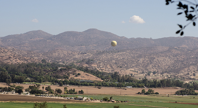
The first 0.5 mile on the trail going west from the SDRP parking lot/Ysabel trailhead is on the shoulder of Bandy Canyon Road. Few cars use this road, so traffic isn’t a problem. The trail initially passes through coastal sage scrub vegetation heavily infused with non-native invasive species, particularly annual grasses, horehound, fennel, and tamarisk. The trail gradually leaves the road as it progresses west and, as it does, more native coastal sage scrub species are encountered. The trail also climbs gradually after leaving the road, reaching its highest point on Raptor Ridge 2.3 miles from the Ysabel Trailhead. Benches on Raptor Ridge allow hikers to sit and enjoy the view across the agricultural preserve and up the San Pasqual Valley. After enjoying the views, turn back at this point unless a longer hike is desired.
Continuing from the high point, the trail passes through an open oak woodland, with both scrub and inland live oaks, as you descend to the riverbed. Other common species include laurel sumac, lemonade berry, flat top buckwheat, chamise, California sagebrush, black sage, and white sage. Once the trail reaches the river bed, it passes in and out of oak woodland and dense riparian vegetation as it bends south, ultimately arriving at Highland Valley Road and the Old Coach Staging Area. This marks the turnaround point for this longer out-and-back hike.
Please stay on the trail in this agricultural preserve so as not to disturb farming operations and to honor the cooperation with the farmers. The trail may be closed for short durations during growing seasons.
In recent years, Santa Ysabel and Santa Maria creeks have been completely dry, but Ysabel Creek Rd. may not be passable after a storm because it crosses a currently sandy creek bed. While driving down the road, take note of a washed-out bridge demonstrating the potential violence of creeks after a storm.
Distance from downtown San Diego: 32 miles. Allow 40 minutes driving time (San Pasqual Valley Agricultural Preserve). From I-15 N, exit at Via Rancho Parkway and follow the signs for San Diego Zoo’s Safari Park (Bear Valley Pkwy-San Pasqual Rd.) to SR-78 E. Drive past the Safari Park’s entrance for 1.2 miles, turning south onto Ysabel Creek Rd. and drive 0.6 mile to the Ysabel Staging Area/Trailhead, which is marked with a sign “SDRP” but no other sign stating that it is the staging area/trailhead. Park in the day-use-only lot. Caution: the Ysabel Creek Rd. bridge can wash out after rain. In that event or to avoid the chance of a washout, the trailhead on Ysabel Creek Rd. can be reached via I-15 by following W. Bernardo/Pomerado Rd. east to Highland Valley Rd. and then north on Bandy Canyon Rd., and north again onto Ysabel Creek Rd. for about 175 ft. before turning west into the parking lot.
Hiking length: 4.6 miles or optionally 8 miles out-and-back.
Difficulty: from moderate to moderately strenuous if the longer hike is made. Elevation gain/loss is about 900 feet. No facilities or water.