Sponsored
Sponsored
The Kelly Ditch Trail is a 5.6-mile hiking path extending from William Heise County Park to Lake Cuyamaca. Prior to 2003, it passed through one of the most magnificent oak and coniferous forests in San Diego County. The Cedar Fire that year incinerated many of the trees, especially the black oaks and conifers. Their bleached white skeletons continue to tower over the now-green understory where the vegetation has made a remarkable comeback. In fact, in places it came back too strongly. Until last year, ceanothus recovery created dense thickets that were impossible to get through without a machete in parts of the trail. This year, trail crews cleared most of the brush and piles of dead, fallen trees blocking the trail, and the Kelly Ditch Trail is now open all the way through. At the present time, the part of the trail within William Heise County Park presents the most scenic hiking opportunity, but spectacular views and beautiful wildflowers can be found throughout the route.
There are three route possibilities for hiking the Kelly Ditch Trail that begin from Heise Park. (Starting the hike from Lake Cuyamaca is not recommended because there are no facilities there and no place to park near the trailhead.) The first option is a 5.6-mile one-way hike that requires parking a vehicle at the other end. The second option is an 11.2-mile out-and-back hike for more ambitious hikers. The third option is the one described here — a more moderate 5.6-mile out-and-back that goes 2.8 miles before turning back at the trail’s high point. This is also the recommended hike in the future if the ceanothus thicket grows back to block the hike to Lake Cuyamaca.
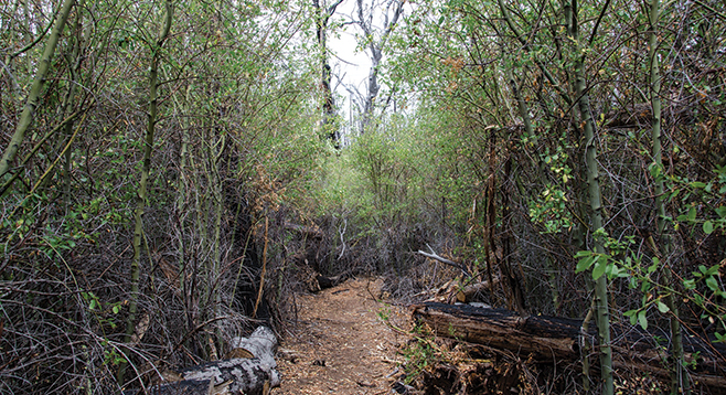
The northern end of the Kelly Ditch Trail begins at the southern terminus of the Heise Park day-use parking area. Follow the signs and begin hiking down the trail lined with foothill penstemon, coffee berry, and Palmer lilac through towering inland live oaks and Coulter pines. The Fern Trail goes off to the right at 0.4 mile from the start while the Kelly Ditch Trail continues straight ahead up a dirt road, passing through an abundance of wild rose, Palmer lilac, willows, white yarrow, and the occasional sierra gooseberry. The live oaks are fire-scarred but most survived. Black oaks typically were killed to the ground, but many have sprouts popping from stumps and show considerable growth. At 0.75 mile into the hike, the Kelly Ditch Trail leaves the road, branching off to the right and heading over a ridge and down to Cedar Creek, a perennial stream flowing even in this drought year. At 1 mile into the hike, the Fern Trail, which looped around, again goes off to the right, while Kelly’s Ditch Trail crosses Cedar Creek and begins its gradual ascent up the northwest side of North Peak. At 1.85 miles into the hike is the Heise Park boundary.
Some of the tallest thickets of lilac are ahead. The trail crew has done a heroic job of clearing the path, making this hike possible. Although the view on either side of the trail is limited, the views behind stretch to the top of Granite Mountain in the Anza-Borrego Desert, peaking over the ridge to the east. At about 2.8 miles from the start, there will be an unused dirt road coming up from Engineer’s Road. The road is now the trail. The vegetation is much more open now. The trail crosses grass and bracken-fern-carpeted meadows, permitting views to the west extending to the ocean and south to Cuyamaca Mountain. In less than a mile, the trail leaves the road, going off to the left. In another 0.3 mile the trail crosses Engineer’s Road and begins its descent to the remnant of the actual Kelly’s Ditch, constructed in the 19th Century to channel runoff from North Peak into the then newly constructed Cuyamaca Reservoir. On the way, keep an eye out for slender sunflower, goldenrod, San Diego gum plant, Humboldt lily, California barberry, foothill penstemon, and many other plants that may be in flower during your visit. The trail ends just west of where Hwy 79 curves around the Cuyamaca reservoir dam. Currently the trail sign is missing.