Sponsored
Sponsored
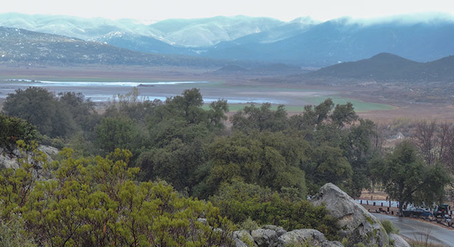
The start of this loop is along a portion of the 2650-mile long Pacific Crest Trail (PCT) with views of Lake Morena and the Laguna Mountains. Lake Morena is owned by the City of San Diego and is the highest and most remote of the city’s reservoirs. It is the fourth oldest and the third largest reservoir in San Diego’s water-storage system and was constructed between 1897 and 1912. Presently the lake is less than 5 percent of capacity due to continuing drought conditions and the transferring of water to other storage reservoirs in order to reduce the amount of water lost to evaporation.
The six-mile walk begins from the back of the PCT parking lot just outside of the Lake Morena County Park. Parking is available on either side of the lot, but note there is a $3 fee required for the northwest portion. A gently climbing trail leads through dense mixed chaparral. A variety of wildflowers may be seen on either side of the trail, including woolly blue curls and the rare southern jewel plant. Also, note the stands of redshank with its ribbonlike peeling bark, some growing next to the other species of chamise (Adenostoma). Stop at any of several overlooks for vistas of the lake and surrounding area. Ask any backpackers encountered their origin and destination. Depending on the season, they may be either starting or finishing the PCT trail that runs from Mexico to Canada.
The first half of the hike is on the PCT where the trail signs are easy to follow. At 1.8 miles, crest a low rise and start a gradual descent. At about 2.7 miles, the trail will leave the PCT. Be on the lookout for a somewhat obscure trail (old roadbed) going uphill on the right (N32 40.099’ W116 32.016). If you get to the Morena Butte trail, you have gone too far and will need to retrace your steps about 0.2 mile. After a moderate climb of 0.5 mile and gaining 100 feet, there will be a dirt road that will lead northwest though Ward’s Flats meadow, a beautiful area underneath the massive granitic presence of Morena Butte and dotted with live oaks and Coulter pines. In season, the valley floor may be carpeted in wildflowers. Note feral pig rooting damage in the meadow, which also exists further west into Hauser Canyon.
Here also may be the remains of Charles Hatfield’s rainmaking tower that may have been responsible for the 35-plus inches of rain that fell in January 1916, causing widespread destruction and over 15 deaths in San Diego County. Stop on the steps of the ruins of an old hunting lodge for lunch before returning to the starting point by way of the Morena Reservoir’s shoreline road, keeping the lake on your left for 2 miles.
A Pacific Crest Bicycle Trail closely parallels the PCT on roads. An out-of-print book by Bil Paul has a map on the back cover showing the alignment between the two trails.