Sponsored
Sponsored
Viejas Mountain is a sacred mountain to the Kumeyaay Indians who made a pilgrimage to the summit to watch the sun rise over Buckman Peak for winter solstice. A marker made of rocks pointed 16 miles to the southeast to the 4641-foot peak and was used to help create a windbreak in the 1970s.
Flowers abound in the spring, including yucca and ceanothus, with hummingbirds and swallowtail butterflies that are delightful. Shrub oak, felt-leafed yerba santa, chamise, and manzanita blanket the mountain that is green again, ten years after the 2003 Cedar Fire scoured the mountain.
Starting at 2700 feet, the trail begins with a gentle slope and then starts to climb relentlessly at an average grade of 20 percent. Stop and look at the amazing views of San Diego County’s valleys and mountains as you climb. El Cajon Mountain in its vast granite glory will be behind you. As 3000 feet is reached, Palomar and San Jacinto mountains come into view with San Gorgonio Mountain visible at 3300 feet. The views just keep getting better as you climb.
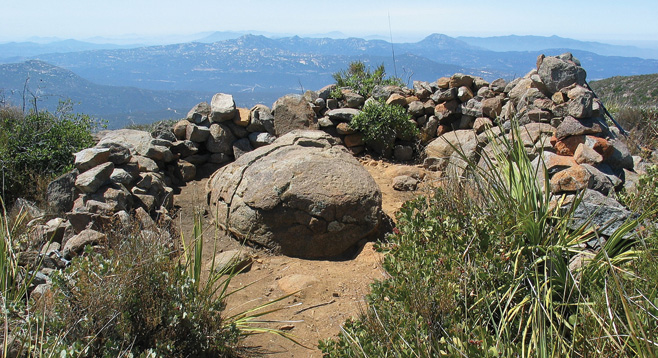
At 3840 feet you can take a climbing break with an inviting flat stretch of the trail. This is a good place to look for the El Capitan Reservoir, name the peaks that are visible, or find the Coronado Islands or even the plateau in Rosarito in Baja California, Mexico! When you reach the saddle at 4100 feet, Cuyamaca Peak, the second highest mountain of San Diego County, comes into view along with the desert peaks to the east and the Viejas Casino at your feet. From the saddle, reaching the summit is a short walk northerly with 80 feet of vertical gain. If a Santa Ana wind is blowing, it may get windy but the visibility is best. At the 4187-foot summit, there is a rock wind shelter with a boulder in the center. Sit and enjoy the beauty of the granitic peaks of San Diego County before returning on the same trail.
The hike is enjoyable all year long, but it can be very hot in the summer months, so start early. Look back along the trail climbing to the summit and know your comfort level for the return as the descent is on those same loose rocks, washouts, and slick areas. The chance of having the mountain to yourself is very high as this is a trail less traveled. If the hike is started in the cooler part of the evening, let a friend know what time you plan to return and bring strong headlamps to use on the trail as it is pitch black when the sun sets.