Sponsored
Sponsored
The Mission Trails Visitor Center Loop Trail is a great hike for families with children or for those who want an introduction to San Diego outdoors. It has it all, including a 14,575-square-foot award-winning visitor and interpretive center with both audio and visual displays that help you understand the resources of this 5800-acre park — the nation’s largest urban natural park. It is also a great loop for trail runners, mountain bikers, and dog owners. For those who want a guide, park naturalists lead free interpretive walks on this loop on both Saturday and Sunday mornings at 9:30 a.m.
Before you begin your hike, take time to enjoy the many displays at the visitor center. Learn about how water was transported to San Diego and about the park’s early days as part of Camp Elliott, from 1917 until 1961. The visitor center is open daily from 9 a.m. to 5 p.m.
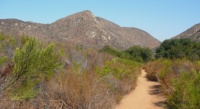
One of the amazing things about this loop is how quickly one can leave the noise of a major street and crowds gathered in the parking area and step into a natural environment. Explore coastal sage scrub, chaparral, and riparian woodlands as you also observe grasslands and oak woodlands.
The hike begins at the parking entrance to the visitor center off Junípero Serra Trail; the trailhead is signed “Visitor Center North Loop.” The loop trail ends on the other side of the drive entrance. Begin walking north, noting common chaparral plants encountered at the beginning of the loop, which include laurel sumac, chamise, buckwheat, and chaparral broom. The large peak straight ahead is South Fortuna Mountain.
As you approach the San Diego River, cottonwoods will come into view. At mile 0.36 a sign indicates the turnoff to the riverside grinding site where bedrock morteros may be seen. It was here that early-day Kumeyaay would grind their collected seeds and acorns to prepare them for meals. Take this short jaunt if you want to see the grinding area and then return to the junction to continue the loop.
As the trail begins to follow the river, more riparian plants become visible, including mulefat, sycamores, willows, and juncus, used by the Kumeyaay for making collection baskets. Watch out for poison oak near the trail. At about mile 0.9 there is a junction with the trail leading to Fortuna Mountain. Go left and head up the hill, passing a small stream to your right. Note the blocks of ancient granite that rise above the stream bed where cattails are visible. The green material floating in the pond eddies is called pond scum or pond moss. It is a freshwater algae that is photosynthetic (a chlorophyte) that typically forms greenish mats on the water’s surface, especially during dryer months when water is stagnant.
The loop continues past the Jackson Street overflow parking area, where a porta-potty is located. Water provided for hand-washing is not for human consumption. As the road parallels Mission Gorge, the quiet is interrupted with the sounds of street traffic and soon the parking area comes into view. For more information check mtrp.org.